METAR & TAF O37
O37 does not publish a METAR.
Showing the nearest reporting station: KCIC (CHICO RGNL) · 14.0 NM away. Conditions at O37 may differ.
METAR · KCIC
Observed 01:47Z
KCIC 270147Z 16008KT 10SM CLR 35/04 A2988
- Wind
- 160° @ 8 kt
- Visibility
- 10 SM
- Temp / Dew
- 35°C / 4°C
- Altimeter
- 29.88 inHg
- Clouds
- CLR
- Density alt
- 2,720 ft
- Ceiling
- Unlimited
- Rules
- VFR
Airport info & contacts
Manager on record, flight service, ARTCC, attendance schedule and pattern altitude — published by the FAA and refreshed every 28 days.
Location
- From city
- 3 NM SE
- VFR sectional
- SAN FRANCISCO
- ARTCC
- ZOA · OAKLAND
- NOTAM facility
- RIU (NOTAM-D)
Airport manager
- Name
- DONALD RUST
- Phone
- 530-934-6530
- Address
- PO BOX 1070, WILLOWS CA 95988
Flight service · Hours
- FSS RIU
- RANCHO MURIETA1-800-WX-BRIEF
- Attendance
- MON-FRI · 0700-1530
Frequencies
Tap any row to copy the frequency to your clipboard.
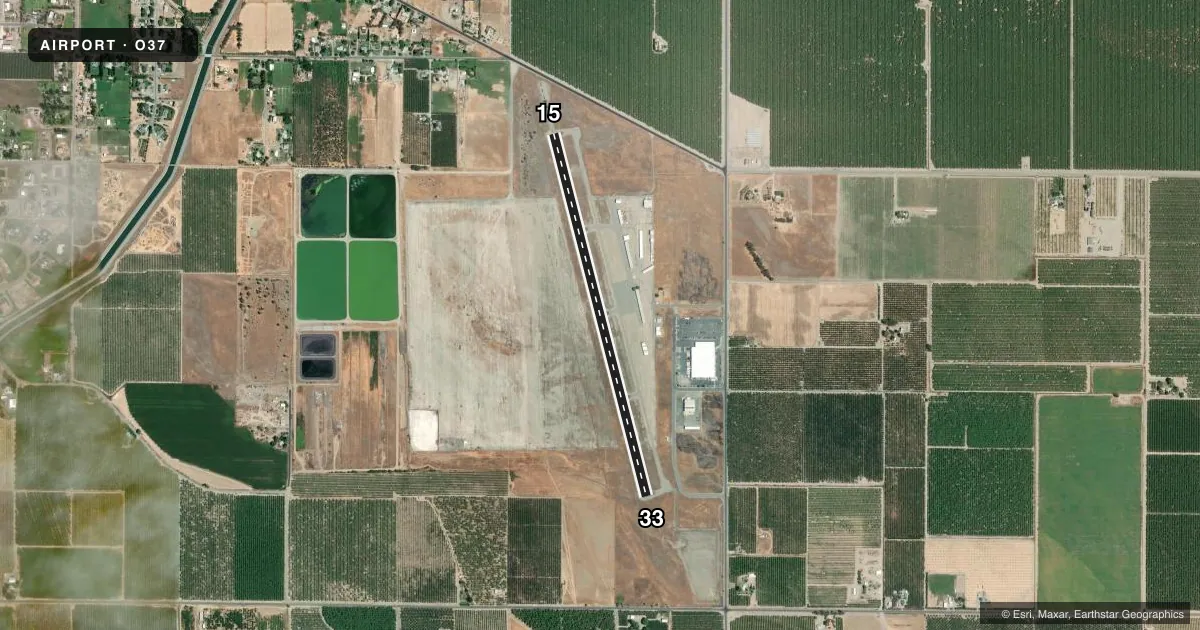
Runways & pattern
Full pagePattern entry · RWY 15
LEFT TRAFFICRunway end performance
| End | TORA | TODA | ASDA | LDA | VGSI | Approach lights | Obstruction |
|---|---|---|---|---|---|---|---|
| 15 | — | — | — | — | PAPI 2-box left(3.5°) | — | 15', road, 700' from thr, 125' R of cntrln, slope 33 |
| 33 | — | — | — | — | PAPI 2-box left(3.5°) | — | 30', pole, 1200' from thr, 125' R of cntrln, slope 33 |
Declared distances in feet. TORA = takeoff run available, TODA = takeoff distance, ASDA = accelerate-stop, LDA = landing distance.
Airport sketch
Runways drawn to scale from FAA survey coordinates, rendered over satellite imagery. Not for navigation.
Approaches & charts
Services on the field
Fuel grades, oxygen, maintenance, ramp storage and lighting — as declared to the FAA by the airport operator.
Fuel & services
- Fuel
- 100LL
- Oxygen (bottled)
- Not available
- Oxygen (bulk)
- Not available
- Airframe repair
- Major
- Power plant repair
- Major
Ramp & ground
- Transient storage
- Tie-down
- Landing fee
- No fee published
- Customs
- Not available
- Lighting schedule
- SEE RMK
- Beacon schedule
- SS-SR
- Beacon
- White / Green (civil land)(WG)
- Wind indicator
- Lighted
- Segmented circle
- Yes
Fuel & FBOs
Cheapest 100LL and Jet A on the field and nearby. Always confirm with the FBO before taxi.
Airport notes
Surface conditions, obstructions, local procedures, lighting outages and other notes published with each FAA cycle.
General notes
- FOR CD CTC OAKLAND ARTCC AT 510-745-3380.
Lighting notes
- ACTVT MIRL RWY 15/33 - CTAF.
- ULTRALIGHT ACTIVITY ON & INVOF ARPT.
Other notes
- MANAGERDIRECTOR PUBLIC WORKS
- MANAGEROFFICE AT ORLAND ARPT PHONE 530-624-0836.
VFR map & nearby airports
VFR sectional. Tap any ICAO chip to open that airport.
Key facts · O37
Answer card- ICAO
- O37
- Name
- HAIGH FLD
- Location
- ORLAND, CALIFORNIA
- Elevation
- 217.7 ft MSL
- Traffic pattern altitude
- 1,217.7 ft MSL (1,000 AGL)
- Control tower
- Non-towered (use CTAF)
- Total runways
- 1
- Longest runway
- 15/33 · 4,500 ft
- Published ILS approaches
- 0
- Published frequencies
- 2
- Magnetic variation
- 14°
- Current flight rules
- VFR
- Current wind
- 160° at 8 kt
- Favored runway now
- RWY 15
Haigh Fld sits in Orland, California. Field elevation is 217.7 ft MSL. The airport has one runway. Runway 15/33 is 4,500 ft of asphalt, which is the longest runway on the field. There is no control tower. CTAF and UNICOM are both 122.7. No ILS approaches are published here.
Pattern altitude is not published. Use the standard 1,000 ft AGL unless the current Chart Supplement or local procedures say otherwise. The on-field FBO is Haigh Field. It carries 100LL. Call the field directly at (530) 865-1173 for current service details.
Published remarks matter here. Ultralight activity occurs on and near the airport, so keep a sharp scan in the pattern and on final. Medium intensity runway lights on 15/33 are activated by CTAF. For clearance delivery, contact Oakland Air Route Traffic Control Center at 510-745-3380. The airport manager is the Director of Public Works, with the manager's office at Orland Airport at 530-624-0836. This is a non-towered field, so expect self-announce traffic and coordinate early if you are arriving at busy times.