METAR & TAF KCIC
Current METAR
Observed 15:15Z
KCIC 251515Z AUTO 13006KT 10SM CLR 20/12 A2997 RMK AO1
- Wind
- 130° @ 6 kt
- Visibility
- 10 SM
- Temp / Dew
- 20°C / 12°C
- Altimeter
- 29.97 inHg
- Clouds
- CLR
- Density alt
- 836 ft
- Ceiling
- Unlimited
- Rules
- VFR
Airport info & contacts
Manager on record, flight service, ARTCC, attendance schedule and pattern altitude — published by the FAA and refreshed every 28 days.
Location
- From city
- 4 NM N
- VFR sectional
- SAN FRANCISCO
- ARTCC
- ZOA · OAKLAND
- NOTAM facility
- CIC (NOTAM-D)
Airport manager
- Name
- TOM BAHR
- Phone
- 530-896-7216
- Address
- 150 AIRPARK BLVD., SUITE 110, CHICO CA 95973
Flight service · Hours
- FSS RIU
- RANCHO MURIETA1-800-WX-BRIEF
- Attendance
- 0700-1900
Frequencies
Tap any row to copy the frequency to your clipboard.
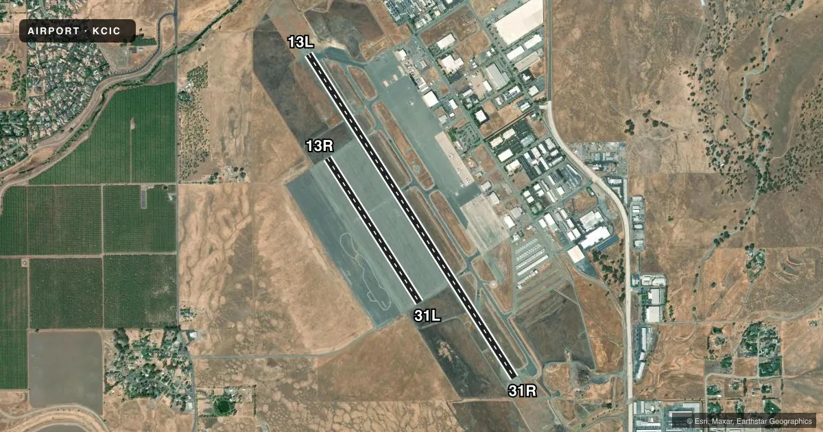
Runways & pattern
Full pagePattern entry · RWY 13L
RIGHT TRAFFIC| Runway | Heading (°M) | Length | Surface | Traffic |
|---|---|---|---|---|
| 13L/31RFavored | 131° / 311° | 6,724 ft | ASPH | 13L R |
| 13R/31L | 131° / 311° | 3,000 ft | ASPH | 13R R |
Runway end performance
| End | TORA | TODA | ASDA | LDA | VGSI | Approach lights | Obstruction |
|---|---|---|---|---|---|---|---|
| 13L | 6,724' | 6,724' | 6,724' | 6,724' | PAPI 4-box left(3°) | MALSR | — |
| 31R | 6,724' | 6,724' | 6,724' | 6,724' | VASI 4-box left(3°) | — | — |
| 13R | 3,000' | 3,000' | 3,000' | 3,000' | — | — | — |
| 31L | 3,000' | 3,000' | 3,000' | 3,000' | — | — | — |
Declared distances in feet. TORA = takeoff run available, TODA = takeoff distance, ASDA = accelerate-stop, LDA = landing distance.
Airport sketch
Runways drawn to scale from FAA survey coordinates, rendered over satellite imagery. Not for navigation.
Approaches & charts
ILS · 1
Services on the field
Fuel grades, oxygen, maintenance, ramp storage and lighting — as declared to the FAA by the airport operator.
Fuel & services
- Fuel
- 100LLA
- Oxygen (bottled)
- High pressure
- Airframe repair
- Major
- Power plant repair
- Major
- Other services
- AFRT,AGRI,AVNCS,CHTR,INSTR,RNTL,SALES
Ramp & ground
- Transient storage
- Tie-down
- Landing fee
- No fee published
- Customs
- Not available
- Lighting schedule
- SEE RMK
- Beacon schedule
- SS-SR
- Beacon
- White / Green (civil land)(WG)
- Wind indicator
- Lighted
- Segmented circle
- Yes
Fuel & FBOs
Cheapest 100LL and Jet A on the field and nearby. Always confirm with the FBO before taxi.
Airport notes
Surface conditions, obstructions, local procedures, lighting outages and other notes published with each FAA cycle.
General notes
- FOR JET/HVY ACFT OPER EAST OF FLD TPA 1500 FT AGL; FOR LGT ACFT OPER WEST & EAST OF FLD TPA 1000 FT AGL.
- BIRDS ON AND IN VCNTY OF ARPT.
- FUEL AVBL 0730-1900. FOR AFTER HRS FUEL CALL 530-588-4888.
Lighting notes
- WHEN ATCT CLSD ACTVT MALSR RWY 13L; REIL RWY 31R; PAPI RWY 13L; VASI RWY 31R; HIRL RWY 13L/31R - CTAF.
Fuel notes
- 100LLFOR FUEL AFT HRS CALL (530) 588-4888
Other notes
- PPR FOR SKEDD ACR SER INVOLVING ACFT WITH MORE THAN 9 PAX SEATS AND UNSKEDD ACR SER INVOLVING ACFT WITH MORE THAN 30 PAX SEATS. WITHOUT PPR, ARFF SERS MAY NOT BE AVBL. FOR PPR CTC AMGR, 530-896-7216.
VFR map & nearby airports
VFR sectional. Tap any ICAO chip to open that airport.
Key facts · KCIC
Answer card- ICAO
- KCIC
- Name
- CHICO RGNL
- Location
- CHICO, CALIFORNIA
- Elevation
- 240.2 ft MSL
- Traffic pattern altitude
- 1,240.2 ft MSL (1,000 AGL)
- Control tower
- Towered · 0700-1900
- Total runways
- 2
- Longest runway
- 13L/31R · 6,724 ft
- Published ILS approaches
- 1
- Published frequencies
- 6
- Magnetic variation
- 16°
- Current flight rules
- VFR
- Current wind
- 130° at 6 kt
- Favored runway now
- RWY 13L
Chico Rgnl sits in Chico, California. Field elevation is 240.2 ft MSL. The airport has two asphalt runways. The longest is 13L/31R at 6,724 ft. The shorter runway is 13R/31L at 3,000 ft. The field is towered from 0700 to 1900.
Runway 13L has the ILS. That is the only published ILS approach in the facts. Pattern altitude is not published for the airport as a whole. For light piston traffic, use 1,000 ft AGL. That puts the pattern at 1,240.2 ft MSL. For jet and heavy aircraft east of the field, the published pattern altitude is 1,500 ft AGL.
Northgate Aviation - Chico Jet Center is on the field. It carries 100LL, Jet A and Jet A Prist. Fuel is available from 0730 to 1900. After hours fuel is available by phone. Confirm that before a late arrival. Birds are reported on and near the airport. Keep a sharp scan on taxi, departure and approach. When the tower is closed, the published lighting setup for 13L includes the approach lights, runway alignment indicator lights, PAPI and high intensity runway lights on CTAF. Check the current FAA Chart Supplement for any current noise or curfew restrictions before flying in.