METAR & TAF KWLW
KWLW does not publish a METAR.
Showing the nearest reporting station: KCIC (CHICO RGNL) · 23.6 NM away. Conditions at KWLW may differ.
METAR · KCIC
Observed 01:47Z
KCIC 270147Z 16008KT 10SM CLR 35/04 A2988
- Wind
- 160° @ 8 kt
- Visibility
- 10 SM
- Temp / Dew
- 35°C / 4°C
- Altimeter
- 29.88 inHg
- Clouds
- CLR
- Density alt
- 2,625 ft
- Ceiling
- Unlimited
- Rules
- VFR
Airport info & contacts
Manager on record, flight service, ARTCC, attendance schedule and pattern altitude — published by the FAA and refreshed every 28 days.
Location
- From city
- 1 NM W
- VFR sectional
- SAN FRANCISCO
- ARTCC
- ZOA · OAKLAND
- NOTAM facility
- RIU (NOTAM-D)
Airport manager
- Name
- TALIA RICHARDSON
- Phone
- 530-934-6530
- Address
- 777 NORTH COLUSA STREET, WILLOWS CA 95988
Flight service · Hours
- FSS RIU
- RANCHO MURIETA1-800-WX-BRIEF
- Attendance
- 0730-1530
Frequencies
Tap any row to copy the frequency to your clipboard.
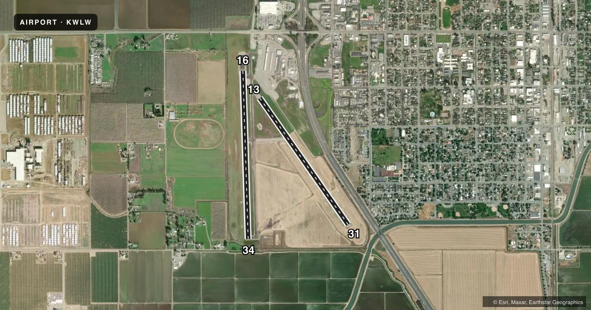
Runways & pattern
Full pagePattern entry · RWY 13
RIGHT TRAFFIC| Runway | Heading (°M) | Length | Surface | Traffic |
|---|---|---|---|---|
| 16/34 | 164° / 344° | 4,125 ft | ASPH | 16 R |
| 13/31Favored | 131° / 311° | 3,788 ft | ASPH | 13 R |
Runway end performance
| End | TORA | TODA | ASDA | LDA | VGSI | Approach lights | Obstruction |
|---|---|---|---|---|---|---|---|
| 16 | — | — | — | — | — | — | 15', road, 550' from thr, 0' R of cntrln, slope 23 |
| 34 | — | — | — | — | VASI 4-box left(3°) | — | — |
| 13 | — | — | — | — | — | — | 50', trees, 1910' from thr, 100' R of cntrln, slope 34 |
Declared distances in feet. TORA = takeoff run available, TODA = takeoff distance, ASDA = accelerate-stop, LDA = landing distance.
Airport sketch
Runways drawn to scale from FAA survey coordinates, rendered over satellite imagery. Not for navigation.
Approaches & charts
Services on the field
Fuel grades, oxygen, maintenance, ramp storage and lighting — as declared to the FAA by the airport operator.
Fuel & services
- Fuel
- 100LL
- Oxygen (bottled)
- Not available
- Oxygen (bulk)
- Not available
- Other services
- AGRI
Ramp & ground
- Transient storage
- Tie-down
- Customs
- Not available
- Lighting schedule
- SEE RMK
- Beacon schedule
- SS-SR
- Beacon
- White / Green (civil land)(WG)
- Wind indicator
- Lighted
- Segmented circle
- Yes
Fuel & FBOs
Cheapest 100LL and Jet A on the field and nearby. Always confirm with the FBO before taxi.
Airport notes
Surface conditions, obstructions, local procedures, lighting outages and other notes published with each FAA cycle.
General notes
- FOR CD CTC OAKLAND ARTCC AT 510-745-3380.
Lighting notes
- ACTVT MIRL RY 16/34 & VASI RY 34 - CTAF.
Fuel notes
- 100LL24HR CARD LOCK
Other notes
- EXISTED PRIOR TO 1959.
- MANAGERPUBLIC WORKS DIRECTOR.
VFR map & nearby airports
VFR sectional. Tap any ICAO chip to open that airport.
Key facts · KWLW
Answer card- ICAO
- KWLW
- Name
- WILLOWS/GLENN COUNTY
- Location
- WILLOWS, CALIFORNIA
- Elevation
- 141.2 ft MSL
- Traffic pattern altitude
- 1,141.2 ft MSL (1,000 AGL)
- Control tower
- Non-towered (use CTAF)
- Total runways
- 2
- Longest runway
- 16/34 · 4,125 ft
- Published ILS approaches
- 0
- Published frequencies
- 2
- Magnetic variation
- 14°
- Current flight rules
- VFR
- Current wind
- 160° at 8 kt
- Favored runway now
- RWY 13
Willows/Glenn County Airport sits in Willows, California. Field elevation is 141.2 ft MSL. The airport has 2 asphalt runways. The longest is runway 16/34 at 4,125 ft. It is an untowered field, so plan to self-announce on CTAF 122.8. No ILS approaches are published here.
Pattern altitude is not published. Use 1,000 ft AGL for light piston traffic unless the current Chart Supplement says otherwise. Glenn County Airport is the on-field FBO. It carries 100LL. Fuel is available 24 hours through a card lock. Runway 16/34 has medium intensity runway lights. Runway 34 also has a visual approach slope indicator on CTAF 122.8.
For clearance delivery, Oakland ARTCC handles it by phone. That matters if you are filing IFR into or out of the field. The airport sits in the Central Valley, so expect routine valley flying conditions rather than mountain terrain, but always check density altitude on warm days. If you need current operational details, confirm them with the airport operator or the FBO directly before departure.