METAR & TAF 1Q5
1Q5 does not publish a METAR.
Showing the nearest reporting station: KUKI (UKIAH MUNI) · 22.6 NM away. Conditions at 1Q5 may differ.
METAR · KUKI
Observed 10:56Z
KUKI 271056Z AUTO 00000KT 10SM CLR 13/09 A3002 RMK AO2 SLP157 T01330094
- Wind
- 000° @ 0 kt
- Visibility
- 10 SM
- Temp / Dew
- 13°C / 9°C
- Altimeter
- 30.02 inHg
- Clouds
- CLR
- Density alt
- 1,992 ft
- Ceiling
- Unlimited
- Rules
- VFR
Airport info & contacts
Manager on record, flight service, ARTCC, attendance schedule and pattern altitude — published by the FAA and refreshed every 28 days.
Location
- From city
- 17 NM N
- VFR sectional
- SAN FRANCISCO
- Pattern altitude
- 800 ft AGL · 2,700 ft MSL
- ARTCC
- ZOA · OAKLAND
- NOTAM facility
- OAK (NOTAM-D)
Airport manager
- Name
- FRANK AEBLY
- Phone
- 707-275-1401
- Address
- 10025 ELK MTN ROAD, UPPER LAKE CA 95485
Flight service · Hours
- FSS OAK
- OAKLAND1-800-WX-BRIEF
- Attendance
- Unattended
Frequencies
Tap any row to copy the frequency to your clipboard.
Runways & pattern
Full pagePattern entry · RWY 01
LEFT TRAFFICRunway end performance
| End | TORA | TODA | ASDA | LDA | VGSI | Approach lights | Obstruction |
|---|---|---|---|---|---|---|---|
| 01 | — | — | — | — | — | — | 36', trees, 600' from thr, 125' R of cntrln, slope 16 |
| 19 | — | — | — | — | — | — | 800', hill, 800' from thr, 0' R of cntrln, slope 1 |
Declared distances in feet. TORA = takeoff run available, TODA = takeoff distance, ASDA = accelerate-stop, LDA = landing distance.
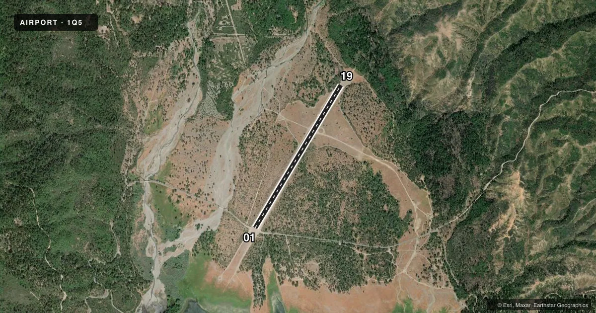
Airport sketch
Runways drawn to scale from FAA survey coordinates, rendered over satellite imagery. Not for navigation.
Approaches & charts
Services on the field
Fuel grades, oxygen, maintenance, ramp storage and lighting — as declared to the FAA by the airport operator.
Fuel & services
- Fuel
- Not available
- Oxygen (bottled)
- Not available
- Oxygen (bulk)
- Not available
- Airframe repair
- Not available
- Power plant repair
- Not available
Ramp & ground
- Transient storage
- Tie-down
- Landing fee
- No fee published
- Customs
- Not available
- Wind indicator
- Yes
- Segmented circle
- Yes
Fuel & FBOs
Cheapest 100LL and Jet A on the field and nearby. Always confirm with the FBO before taxi.
Airport notes
Surface conditions, obstructions, local procedures, lighting outages and other notes published with each FAA cycle.
General notes
- NO LNDG ON RY 19 DUE TO HILL NE OF ARPT.
- NO TKOF ON RY 01 DUE TO HILL NE OF ARPT.
- CAUTION: HANG GLIDER OPS; PARTICULARLY SUMMER MONTHS.
- CAUTION: DO NOT LAND S OF HULL MOUNTAIN ROAD.
- TREES PENETRATE THE TRNSL SFC ON BOTH SIDES OF THE ARPT.
- BE ALERT FOR OCNL WILDLIFE ON RY.
- FOR CD CTC OAKLAND ARTCC AT 510-745-3380.
- RWY IS UNPAVED; THERE MAY BE RUTS AND LARGE ROCKS ON RWY.
Runway surface & condition
- 01/19300' STOPWAY AT SOUTH END OF RWY.
- 01/19BTWN PARALLEL DIRT ROADS.
Approach & departure obstructions
- 01THR MARKED WITH WHITE TIRES.
- 19MKD WITH WHITE TIRES.
Other notes
- E111: PREDATES 1958 FA ACT.
- MANAGERDISTRICT RANGER.
- MANAGERUPPER LAKE RANGER DISTRICT, UPPER LAKE.
- 01/19RWY WAS GRADED IN JULY 2025.
VFR map & nearby airports
VFR sectional. Tap any ICAO chip to open that airport.
Key facts · 1Q5
Answer card- ICAO
- 1Q5
- Name
- GRAVELLY VALLEY
- Location
- UPPER LAKE, CALIFORNIA
- Elevation
- 1,900 ft MSL
- Traffic pattern altitude
- 2,700 ft MSL (800 AGL)
- Control tower
- Non-towered (use CTAF)
- Total runways
- 1
- Longest runway
- 01/19 · 4,050 ft
- Published ILS approaches
- 0
- Published frequencies
- 1
- Magnetic variation
- 17°
- Current flight rules
- VFR
- Current wind
- 000° at 0 kt
- Favored runway now
- –
Gravelly Valley Airport sits near Upper Lake, California. Field elevation is 1,900 ft MSL. It has one runway. Runway 01/19 is 4,050 ft long and gravel. There is no control tower. CTAF is 122.9. No ILS approaches are published here.
Pattern altitude is 800 ft AGL, which is 2,700 ft MSL. The runway is unpaved, so expect ruts and large rocks. The runway was graded in July 2025, but it is still a backcountry surface that deserves a careful walk-around and a conservative landing plan. The runway sits between parallel dirt roads. Do not land south of Hull Mountain Road. No takeoff is permitted on runway 01 because of a hill northeast of the airport.
Published remarks also call out hang glider activity, especially in summer, plus occasional wildlife on the runway. The threshold of runway 01 is marked with white tires. Runway 19 is also marked with white tires. The airport manager is the district ranger. Contact the Upper Lake Ranger District in Upper Lake for current field status and local coordination. With no on-field FBOs listed, plan to verify services directly before you go.