METAR & TAF O60
O60 does not publish a METAR.
Showing the nearest reporting station: KSTS (CHARLES M SCHULZ/SONOMA COUNTY) · 18.1 NM away. Conditions at O60 may differ.
METAR · KSTS
Observed 11:53Z
KSTS 271153Z AUTO 00000KT 10SM CLR 11/09 A2999 RMK AO2 SLP147 T01060094 10144 20100 55001 $
- Wind
- 000° @ 0 kt
- Visibility
- 10 SM
- Temp / Dew
- 11°C / 9°C
- Altimeter
- 29.99 inHg
- Clouds
- CLR
- Density alt
- -225 ft
- Ceiling
- Unlimited
- Rules
- VFR
Airport info & contacts
Manager on record, flight service, ARTCC, attendance schedule and pattern altitude — published by the FAA and refreshed every 28 days.
Location
- From city
- 3 NM SE
- VFR sectional
- SAN FRANCISCO
- ARTCC
- ZOA · OAKLAND
- NOTAM facility
- OAK (NOTAM-D)
Airport manager
- Name
- DERRICK MONTANYE
- Phone
- 707-894-1722
- Address
- 124 N. CLOVERDALE BLVD., CLOVERDALE CA 95425
Flight service · Hours
- FSS OAK
- OAKLAND1-800-WX-BRIEF
- Attendance
- 0800-1700
Frequencies
Tap any row to copy the frequency to your clipboard.
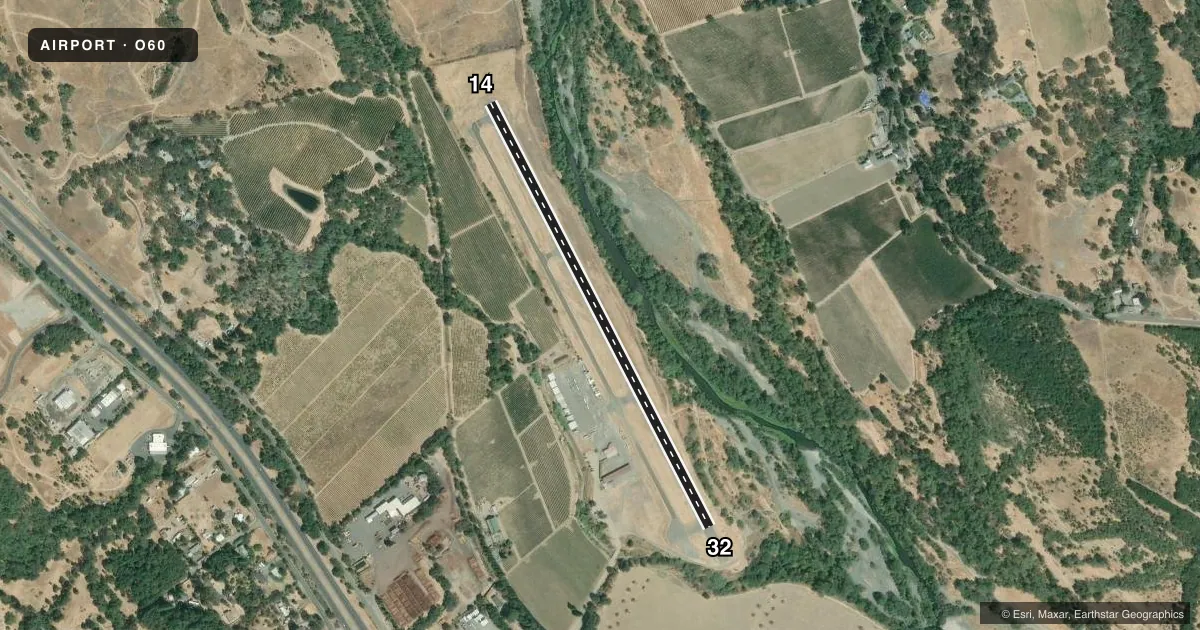
Runways & pattern
Full pagePattern entry · RWY 14
LEFT TRAFFICRunway end performance
| End | TORA | TODA | ASDA | LDA | VGSI | Approach lights | Obstruction |
|---|---|---|---|---|---|---|---|
| 14 | — | — | — | — | PAPI 2-box left(3°) | — | — |
| 32 | — | — | — | — | PAPI 2-box left(3.5°) | — | 15', brush, 200' from thr, 0' R of cntrln, slope 0 |
Declared distances in feet. TORA = takeoff run available, TODA = takeoff distance, ASDA = accelerate-stop, LDA = landing distance.
Airport sketch
Runways drawn to scale from FAA survey coordinates, rendered over satellite imagery. Not for navigation.
Approaches & charts
Services on the field
Fuel grades, oxygen, maintenance, ramp storage and lighting — as declared to the FAA by the airport operator.
Fuel & services
- Fuel
- 100LL
- Oxygen (bottled)
- Not available
- Oxygen (bulk)
- Not available
- Other services
- INSTR,PAJA,RNTL,SALES
Ramp & ground
- Transient storage
- Tie-down
- Landing fee
- No fee published
- Customs
- Not available
- Lighting schedule
- SEE RMK
- Wind indicator
- Lighted
- Segmented circle
- Yes
Fuel & FBOs
Cheapest 100LL and Jet A on the field and nearby. Always confirm with the FBO before taxi.
Airport notes
Surface conditions, obstructions, local procedures, lighting outages and other notes published with each FAA cycle.
General notes
- FOR CD CTC OAKLAND ARTCC AT 510-745-3380.
Lighting notes
- ACTVT PAPI RWY 14 AND MIRL RWY 14/32 - CTAF.
Fuel notes
- 100LLFUEL AVBL 24 HRS WITH CREDIT CARD.
Approach & departure obstructions
- 32RWY 32 +10 FT ROAD AT 0 FT & 105 FT L; +4 FT FENCE AT 0 FT & 125 FT L; +20 FT BRUSH AT 200 FT & 100 FT R.
- 14UNUSBL BYD 3.3 NM.
VFR map & nearby airports
VFR sectional. Tap any ICAO chip to open that airport.
Key facts · O60
Answer card- ICAO
- O60
- Name
- CLOVERDALE MUNI
- Location
- CLOVERDALE, CALIFORNIA
- Elevation
- 275.9 ft MSL
- Traffic pattern altitude
- 1,275.9 ft MSL (1,000 AGL)
- Control tower
- Non-towered (use CTAF)
- Total runways
- 1
- Longest runway
- 14/32 · 2,909 ft
- Published ILS approaches
- 0
- Published frequencies
- 2
- Magnetic variation
- 16°
- Current flight rules
- VFR
- Current wind
- 000° at 0 kt
- Favored runway now
- –
Cloverdale Muni sits in Cloverdale, California. The field elevation is 275.9 ft MSL. It has one runway, 14/32, which is 2,909 ft long. There is no control tower. CTAF and UNICOM are both 122.8. No ILS approaches are published here.
Pattern altitude is not published. Use the standard 1,000 ft AGL for light piston traffic unless the current Chart Supplement says otherwise. That puts the pattern at about 1,276 ft MSL. The runway headings are magnetic 153° and 333°. The runway is asphalt.
Cloverdale Municipal Airport is the on-field FBO. It carries 100LL. Fuel is available 24 hours with credit card. The published remarks also note that runway 32 has close-in obstructions near the threshold area. There is a road. There is a fence. Brush is near the approach end and right side. Runway 14 is unusable beyond 3.3 NM. The runway lights and PAPI for runway 14 are activated by CTAF. For clearance delivery, contact Oakland ARTCC.
For a first-time arrival, the main things to plan for are the short single runway, the published obstruction notes and the lack of tower or ILS support. Check the current Chart Supplement before departure for any updates to pattern work, lighting, or local procedures.