METAR & TAF D83
D83 does not publish a METAR.
Showing the nearest reporting station: KUKI (UKIAH MUNI) · 10.8 NM away. Conditions at D83 may differ.
METAR · KUKI
Observed 04:56Z
KUKI 270456Z AUTO 02007KT 10SM CLR 20/09 A3004 RMK AO2 SLP166 T02000089
- Wind
- 020° @ 7 kt
- Visibility
- 10 SM
- Temp / Dew
- 20°C / 9°C
- Altimeter
- 30.04 inHg
- Clouds
- CLR
- Density alt
- 921 ft
- Ceiling
- Unlimited
- Rules
- VFR
Airport info & contacts
Manager on record, flight service, ARTCC, attendance schedule and pattern altitude — published by the FAA and refreshed every 28 days.
Location
- From city
- 1 NM NW
- VFR sectional
- SAN FRANCISCO
- Pattern altitude
- 800 ft AGL · 1,179 ft MSL
- ARTCC
- ZOA · OAKLAND
- NOTAM facility
- OAK (NOTAM-D)
Airport manager
- Name
- KIRK WILDER
- Phone
- 707-234-9593
- Address
- 13461 AIRPORT ROAD, BOONVILLE CA 95415
Flight service · Hours
- FSS OAK
- OAKLAND1-800-WX-BRIEF
- Attendance
- Unattended
Frequencies
Tap any row to copy the frequency to your clipboard.
Runways & pattern
Full pagePattern entry · RWY 31
RIGHT TRAFFICRunway end performance
| End | TORA | TODA | ASDA | LDA | VGSI | Approach lights | Obstruction |
|---|---|---|---|---|---|---|---|
| 13 | — | — | — | — | — | — | 35', trees, 400' from thr, 20' R of cntrln, slope 5 |
| 31 | — | — | — | — | — | — | 185', hill, 3900' from thr, 500' R of cntrln, slope 20 |
Declared distances in feet. TORA = takeoff run available, TODA = takeoff distance, ASDA = accelerate-stop, LDA = landing distance.
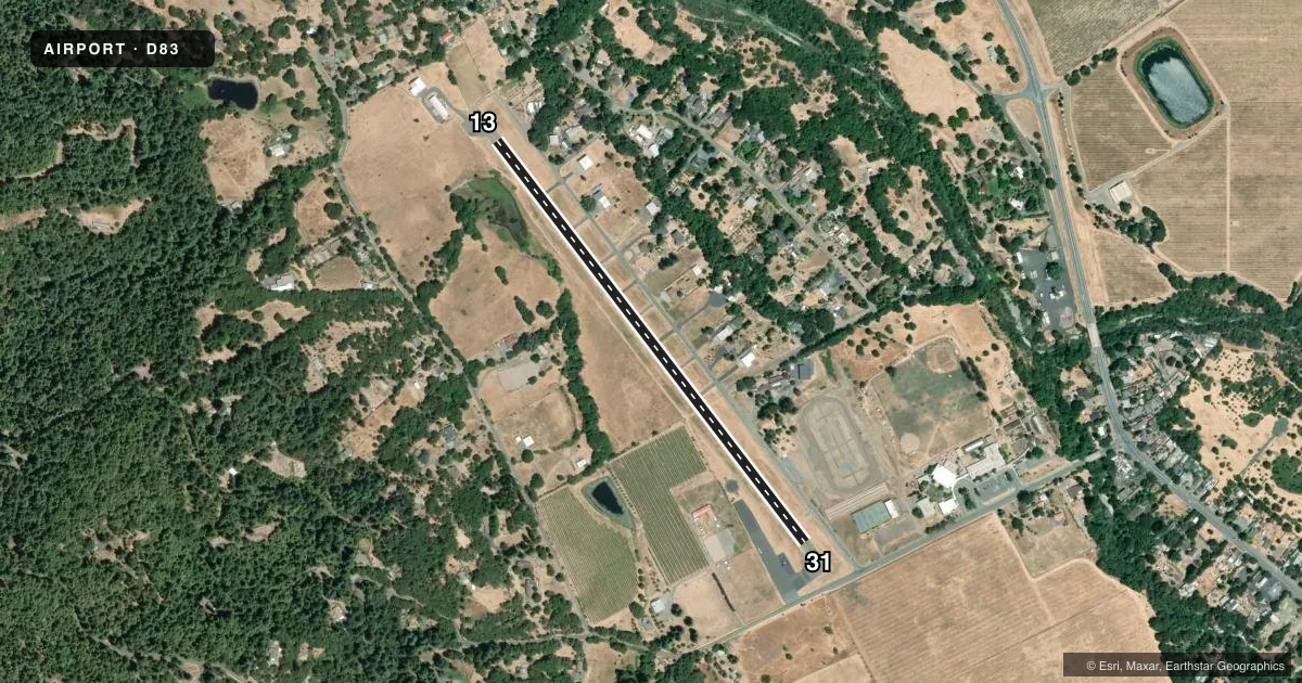
Airport sketch
Runways drawn to scale from FAA survey coordinates, rendered over satellite imagery. Not for navigation.
Approaches & charts
Services on the field
Fuel grades, oxygen, maintenance, ramp storage and lighting — as declared to the FAA by the airport operator.
Fuel & services
- Fuel
- Not available
- Oxygen (bottled)
- Not available
- Oxygen (bulk)
- Not available
- Airframe repair
- Not available
- Power plant repair
- Not available
Ramp & ground
- Transient storage
- Tie-down
- Landing fee
- No fee published
- Customs
- Not available
- Wind indicator
- Yes
- Segmented circle
- Yes
Fuel & FBOs
Cheapest 100LL and Jet A on the field and nearby. Always confirm with the FBO before taxi.
Airport notes
Surface conditions, obstructions, local procedures, lighting outages and other notes published with each FAA cycle.
General notes
- DITCH SW SIDE OF RY 13/31.
- BACK TAXI ON RY, DO NOT MISTAKE COUNTY ROAD FOR TWY.
- FOR CD CTC OAKLAND ARTCC AT 510-745-3380.
Runway surface & condition
- 13/31PAVEMENT GROSS WEIGHT STRENGTH ESTIMATED BY ARPT MGR 12,500 LBS.
Approach & departure obstructions
- 135' FENCE 250' FROM END OF RWY.
- 31PUBLIC ROAD 235' FM RWY END.
- 13APCH RATIO 24:1 TO DSPLCD THLD; APCH RATIO TO DSPLD THLD OVER 92 FT TREES AT 1200 FT, 175 FT R FM EOR 18:1.
- 31APCH RATIO 22:1 TO DSPLCD THR; APCH RATIO TO DSPLCD THR OVER +15 FT ROAD 375 FT FM DSPLCD THR 125 FT LEFT 20:1.
Other notes
- NON COMPLIANCE FAR 157.
VFR map & nearby airports
VFR sectional. Tap any ICAO chip to open that airport.
Key facts · D83
Answer card- ICAO
- D83
- Name
- BOONVILLE
- Location
- BOONVILLE, CALIFORNIA
- Elevation
- 378.5 ft MSL
- Traffic pattern altitude
- 1,178.5 ft MSL (800 AGL)
- Control tower
- Non-towered (use CTAF)
- Total runways
- 1
- Longest runway
- 13/31 · 2,838 ft
- Published ILS approaches
- 0
- Published frequencies
- 2
- Magnetic variation
- 17°
- Current flight rules
- VFR
- Current wind
- 020° at 7 kt
- Favored runway now
- RWY 31
Boonville Airport sits in Boonville, California. Field elevation is 378.5 ft MSL. The airport has one runway, 13/31, which is 2,838 ft long and paved with asphalt. There is no control tower. CTAF and UNICOM are both 122.7.
Pattern altitude is 800 ft AGL, which is 1,178.5 ft MSL. No ILS approaches are published here, so plan with the current Chart Supplement and your usual local weather checks before arrival. The published remarks matter. There are trees near the approach to runway 13. There is also a road near the runway 31 end. A ditch runs along the southwest side of the runway. The airport manager has estimated pavement strength at 12,500 pounds gross weight.
There are no on-field FBOs listed. Contact the airport operator directly before arrival if you need fuel or other services. For clearance delivery, the published remark points pilots to Oakland ARTCC at 510-745-3380. Back taxi is used on the runway, so do not mistake the county road for a taxiway. First-time pilots should pay close attention to the displaced threshold notes and the obstacle picture on both ends. This is a small field with limited margin for error.