METAR & TAF E55
E55 does not publish a METAR.
Showing the nearest reporting station: KUKI (UKIAH MUNI) · 24.8 NM away. Conditions at E55 may differ.
METAR · KUKI
Observed 18:56Z
KUKI 261856Z AUTO VRB03KT 10SM CLR 27/12 A3001 RMK AO2 SLP154 T02720122
- Wind
- VAR @ 3 kt
- Visibility
- 10 SM
- Temp / Dew
- 27°C / 12°C
- Altimeter
- 30.01 inHg
- Clouds
- CLR
- Density alt
- 2,486 ft
- Ceiling
- Unlimited
- Rules
- VFR
Airport info & contacts
Manager on record, flight service, ARTCC, attendance schedule and pattern altitude — published by the FAA and refreshed every 28 days.
Location
- From city
- 3 NM N
- VFR sectional
- SAN FRANCISCO
- ARTCC
- ZOA · OAKLAND
- NOTAM facility
- OAK (NOTAM-D)
Airport manager
- Name
- JULIE BOWER
- Phone
- 925-337-4145
- Address
- BOX 1000, GUALALA CA 95445
Flight service · Hours
- FSS OAK
- OAKLAND1-800-WX-BRIEF
- Attendance
- Unattended
Frequencies
Tap any row to copy the frequency to your clipboard.
Runways & pattern
Full pagePattern entry · RWY 31
RIGHT TRAFFICRunway end performance
| End | TORA | TODA | ASDA | LDA | VGSI | Approach lights | Obstruction |
|---|---|---|---|---|---|---|---|
| 13 | — | — | — | — | — | — | 85', trees, 1500' from thr, 75' R of cntrln, slope 15 |
| 31 | — | — | — | — | — | — | 40', trees, 1000' from thr, 140' R of cntrln, slope 20 |
Declared distances in feet. TORA = takeoff run available, TODA = takeoff distance, ASDA = accelerate-stop, LDA = landing distance.
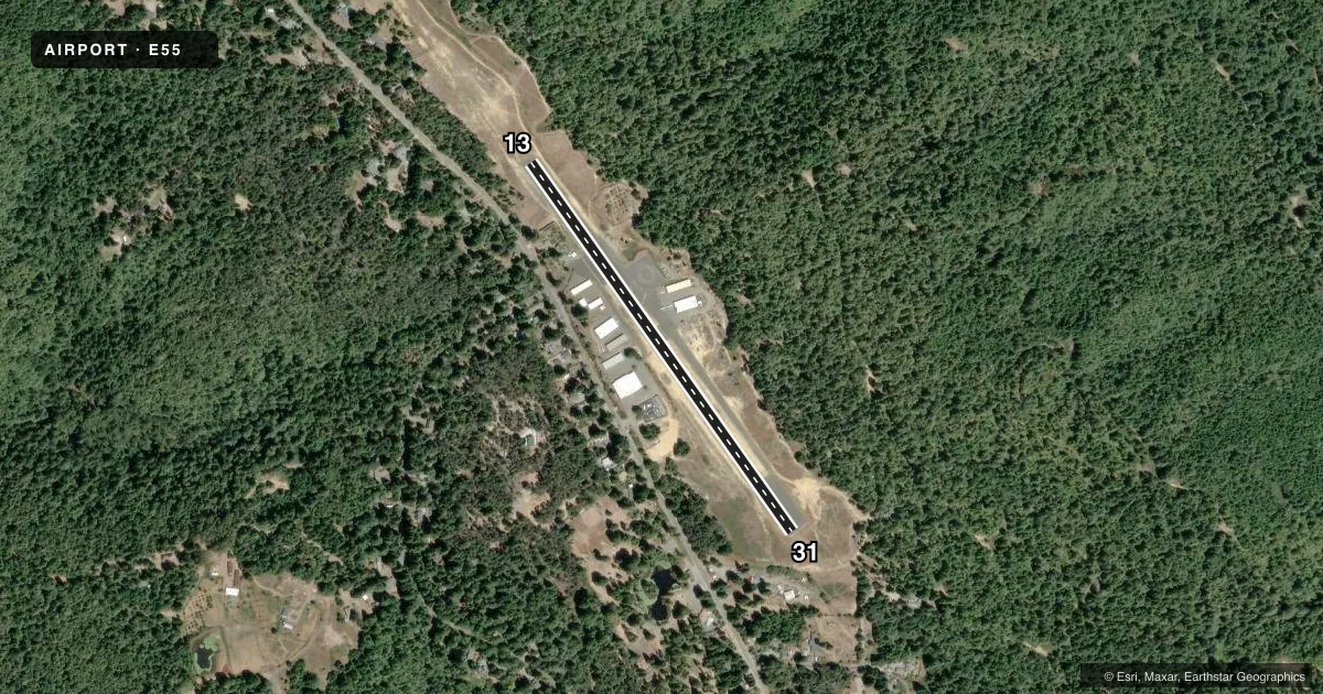
Airport sketch
Runways drawn to scale from FAA survey coordinates, rendered over satellite imagery. Not for navigation.
Approaches & charts
Services on the field
Fuel grades, oxygen, maintenance, ramp storage and lighting — as declared to the FAA by the airport operator.
Fuel & services
- Fuel
- Not available
- Oxygen (bottled)
- Not available
- Oxygen (bulk)
- Not available
- Airframe repair
- Not available
- Power plant repair
- Not available
Ramp & ground
- Transient storage
- Tie-down
- Landing fee
- No fee published
- Wind indicator
- Yes
- Segmented circle
- Yes
Fuel & FBOs
Cheapest 100LL and Jet A on the field and nearby. Always confirm with the FBO before taxi.
Airport notes
Surface conditions, obstructions, local procedures, lighting outages and other notes published with each FAA cycle.
General notes
- CALMWIND RWY 31.
- DEER FREQUENTLY ON RY.
- EXTREME TURB IN WINDY CONDS.
- RWY 13/31/ CLSD AT NIGHT. NO RWY LGTS.
- RY 13/31 CLSD TO JETS AND ULTRALIGHTS.
- RY 13/31 CLSD TO ACFT OVER 8,000 LBS ALLOWABLE TAKE-OFF GROSS WEIGHT.
- RY 13/31 CLSD TO TOUCH AND GO LANDINGS.
- RY SAFETY AREAS HAVE PROTRUDING OR DEPRESSED DRAINAGE AREAS. SAFETY AREA SOUTH END HAS 100+ FOOT DROPOFF.
- FULL STOP LANDINGS ONLY RY 13/31. INTXN TKOFS PROHIBITED. BACK TAXI REQD RY 13. FULL LENGTH TKOF ONLY RY 13/31.
- ACFT NOT VISABLE FM OPPOSITE ENDS OF RY DUE TO DOWNWARD SLOPING TERRAIN FM RY MID-POINT SOUTH TO RY APCH END OF RY 31( APPROX 15 FT DROP).
- FOR CD CTC OAKLAND ARTCC AT 510-745-3380.
- CAUTION WINDSHEAR: DOWNDRAFTS ON SHORT FINAL TO RWY 31 DURG MOD TO STRONG WIND CONDS FROM THE NORTH.
Approach & departure obstructions
- 13RWY 13 APCH RATIO 22:1 TO DSPLCD THLD.
- 31RY 31 APCH RATIO 32:1 TO DSPLCD THLD.
Other notes
- MANAGEREMAIL: JULIEBOWER001@GMAIL.COM
- OWNEREMAIL: JHBOWER@HOTMAIL.COM
VFR map & nearby airports
VFR sectional. Tap any ICAO chip to open that airport.
Key facts · E55
Answer card- ICAO
- E55
- Name
- OCEAN RIDGE
- Location
- GUALALA, CALIFORNIA
- Elevation
- 933.6 ft MSL
- Traffic pattern altitude
- 1,933.6 ft MSL (1,000 AGL)
- Control tower
- Non-towered (use CTAF)
- Total runways
- 1
- Longest runway
- 13/31 · 2,504 ft
- Published ILS approaches
- 0
- Published frequencies
- 2
- Magnetic variation
- 13°
- Current flight rules
- VFR
- Current wind
- 000° at 3 kt
- Favored runway now
- RWY 31
Ocean Ridge (E55) sits in Gualala, California. Field elevation is 933.6 ft MSL. The airport has one runway, 13/31, which is 2,504 ft of asphalt and the longest runway on the field. There is no control tower. CTAF and UNICOM are both 122.8. No ILS approaches are published.
The published pattern altitude is not listed. Use the standard 1,000 ft AGL for light piston operations unless current local guidance says otherwise. With that, the pattern works out to about 1,934 ft MSL at this field. Runway 13/31 is closed at night. There are no runway lights. Full stop landings only are allowed on 13/31. Touch-and-go landings are not allowed. Intersection takeoffs are prohibited. Back taxi is required on runway 13. Full length takeoff only is required on 13/31.
This is a field where you want to brief the runway before you arrive. Deer are frequently on the runway. Aircraft are not visible from opposite ends because the runway slopes down from the midpoint south toward the runway 31 end. Expect turbulence in windy conditions. Calm wind favors runway 31. Runway 13/31 is closed to jets and ultralights. There are no on-field FBOs listed, so verify services with the airport operator or call the field directly before arrival.