METAR & TAF 2O3
2O3 does not publish a METAR.
Showing the nearest reporting station: KSTS (CHARLES M SCHULZ/SONOMA COUNTY) · 18.2 NM away. Conditions at 2O3 may differ.
METAR · KSTS
Observed 09:53Z
KSTS 270953Z AUTO 20003KT 10SM CLR 11/10 A2998 RMK AO2 SLP145 T01110100 $
- Wind
- 200° @ 3 kt
- Visibility
- 10 SM
- Temp / Dew
- 11°C / 10°C
- Altimeter
- 29.98 inHg
- Clouds
- CLR
- Density alt
- 1,771 ft
- Ceiling
- Unlimited
- Rules
- VFR
Airport info & contacts
Manager on record, flight service, ARTCC, attendance schedule and pattern altitude — published by the FAA and refreshed every 28 days.
Location
- From city
- 1 NM E
- VFR sectional
- SAN FRANCISCO
- Pattern altitude
- 850 ft AGL · 2,725 ft MSL
- ARTCC
- ZOA · OAKLAND
- NOTAM facility
- OAK (NOTAM-D)
Airport manager
- Name
- NATHAN TASKER
- Phone
- 707-965-6219
- Address
- 1 ANGWIN AVENUE, ANGWIN CA 94508
Flight service · Hours
- FSS OAK
- OAKLAND1-800-WX-BRIEF
- Attendance
- SUN-FRI · 0800-1700
Frequencies
Tap any row to copy the frequency to your clipboard.
Runways & pattern
Full pagePattern entry · RWY 16
LEFT TRAFFICRunway end performance
| End | TORA | TODA | ASDA | LDA | VGSI | Approach lights | Obstruction |
|---|---|---|---|---|---|---|---|
| 16 | — | — | — | — | PAPI 2-box left(5°) | — | 50', tree, 1000' from thr, 210' R of cntrln, slope 16 |
| 34 | — | — | — | — | PAPI 2-box left(5°) | — | 100', trees, 2100' from thr, 330' R of cntrln, slope 19 |
Declared distances in feet. TORA = takeoff run available, TODA = takeoff distance, ASDA = accelerate-stop, LDA = landing distance.
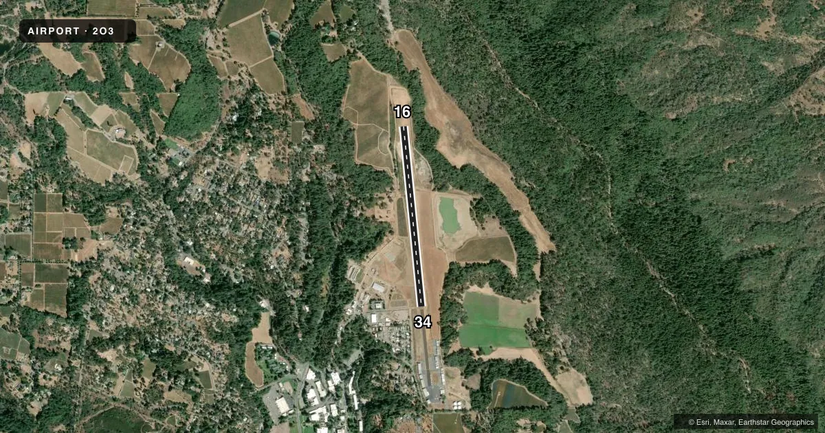
Airport sketch
Runways drawn to scale from FAA survey coordinates, rendered over satellite imagery. Not for navigation.
Approaches & charts
Services on the field
Fuel grades, oxygen, maintenance, ramp storage and lighting — as declared to the FAA by the airport operator.
Fuel & services
- Fuel
- 100LL
- Oxygen (bottled)
- Not available
- Oxygen (bulk)
- HIGH/LOW
- Airframe repair
- Major
- Power plant repair
- Major
- Other services
- INSTR
Ramp & ground
- Transient storage
- Tie-down
- Landing fee
- Yes
- Customs
- Not available
- Lighting schedule
- SEE RMK
- Wind indicator
- Lighted
- Segmented circle
- Yes
Fuel & FBOs
Cheapest 100LL and Jet A on the field and nearby. Always confirm with the FBO before taxi.
Airport notes
Surface conditions, obstructions, local procedures, lighting outages and other notes published with each FAA cycle.
General notes
- FOR CD CTC OAKLAND ARTCC AT 510-745-3380.
- ALL ULTRALIGHTS MUST COMPLY WITH FAR 103 AND HAVE AN OPRG ACFT RADIO.
- PPR FOR SPL OPS.
- NOISE-SENSITIVE AREA WEST OF ARPT.
- NO VEHICLE ACES TO THE RWY.
- ALL TSNT ACFT RQRD TO PARK IN DSGND TSNT AREA. OVNGT FEES APPLY.
- CELL PHONE COVERAGE ON THE GND AT THE ARPT MAY BE UNREL.
- CELL PHONE COVERAGE ON THE GND AT THE ARPT IS NOT AVBL ON SOME CARRIER NETWORKS.
- ARPT CLSD TO NON-EMERG FIXED WING ACFT OVER 12500 LBS MTOW EXCP BY PRIOR ARNGMT (208-618-1396).
- PREFERRED TKOF RWY 16; PREFERRED LNDG RWY 34.
- LOCAL ARPT ADZY (NOT FAA APVD) WX IS AVBL ON CTAF. THREE CLICKS WI 3 SECS GIVES WIND INFO ONLY; FIVE CLICKS WILL GIVE FULL RPRT.
- ARPT CLSD TO NON-EMERG HEL OPS ABOVE 2700 LBS MTOW EXCP BY PRIOR ARNGMT (208-618-1396).
Lighting notes
- ACTVT LIRL RWY 16/34 - CTAF. PAPI RWY 16 & PAPI RWY 34 OPR CONSLY.
Other notes
- ARPT 19 NM E OF SONOMA COUNTY ARPT.
- CTC ARPT FOR LNDG/PRKG FEE SKED.
VFR map & nearby airports
VFR sectional. Tap any ICAO chip to open that airport.
Key facts · 2O3
Answer card- ICAO
- 2O3
- Name
- ANGWIN-PARRETT FLD
- Location
- ANGWIN, CALIFORNIA
- Elevation
- 1,875 ft MSL
- Traffic pattern altitude
- 2,725 ft MSL (850 AGL)
- Control tower
- Non-towered (use CTAF)
- Total runways
- 1
- Longest runway
- 16/34 · 3,217 ft
- Published ILS approaches
- 0
- Published frequencies
- 2
- Magnetic variation
- 16°
- Current flight rules
- VFR
- Current wind
- 200° at 3 kt
- Favored runway now
- RWY 16
Angwin-Parrett Fld sits in Angwin, California at 1,875 ft MSL. It has one runway, 16/34, which is 3,217 ft asphalt. The field is non-towered. CTAF and UNICOM are both 123.0. No ILS approaches are published here.
Pattern altitude is 850 ft AGL, which is 2,725 ft MSL. The published remarks matter here. Runway 16 is the preferred takeoff runway. Runway 34 is the preferred landing runway. There is a noise-sensitive area west of the airport, so plan your pattern work with that in mind. Low intensity runway lights for 16/34 are activated on CTAF. The PAPI for both runway ends operates continuously.
PUC Flight Center is on the field. It carries 100LL. Transient aircraft must park in the designated transient area. Overnight fees apply. Cell coverage can be spotty on some networks. For clearance delivery, contact Oakland ARTCC at 510-745-3380. The airport is 19 NM east of Sonoma County Airport. First-time visitors should treat this as a higher-elevation field with local procedures and limited room for error. Check the current FAA Chart Supplement before you go if you need the latest operational notes.