METAR & TAF 0Q9
0Q9 does not publish a METAR.
Showing the nearest reporting station: KAPC (NAPA COUNTY) · 7.7 NM away. Conditions at 0Q9 may differ.
METAR · KAPC
Observed 10:54Z
KAPC 271054Z AUTO 31004KT 10SM CLR 12/11 A2998 RMK AO2 SLP143 T01170106
- Wind
- 310° @ 4 kt
- Visibility
- 10 SM
- Temp / Dew
- 12°C / 11°C
- Altimeter
- 29.98 inHg
- Clouds
- CLR
- Density alt
- -399 ft
- Ceiling
- Unlimited
- Rules
- VFR
Airport info & contacts
Manager on record, flight service, ARTCC, attendance schedule and pattern altitude — published by the FAA and refreshed every 28 days.
Location
- From city
- 3 NM SE
- VFR sectional
- SAN FRANCISCO
- ARTCC
- ZOA · OAKLAND
- NOTAM facility
- OAK (NOTAM-D)
Airport manager
- Name
- RON PRICE
- Phone
- 707-996-2100
- Address
- 21870 8TH STREET EAST, SONOMA CA 95476
Flight service · Hours
- FSS OAK
- OAKLAND1-800-WX-BRIEF
- Attendance
- 0900-1700
Frequencies
Tap any row to copy the frequency to your clipboard.
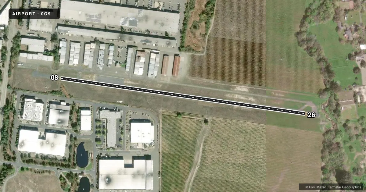
Runways & pattern
Full pagePattern entry · RWY 26
LEFT TRAFFICRunway end performance
| End | TORA | TODA | ASDA | LDA | VGSI | Approach lights | Obstruction |
|---|---|---|---|---|---|---|---|
| 08 | — | — | — | — | — | — | 120', trees, 1100' from thr, 160' R of cntrln, slope 7 |
| 26 | — | — | — | — | — | — | 60', trees, 234' from thr, 150' R of cntrln, slope 0 |
Declared distances in feet. TORA = takeoff run available, TODA = takeoff distance, ASDA = accelerate-stop, LDA = landing distance.
Airport sketch
Runways drawn to scale from FAA survey coordinates, rendered over satellite imagery. Not for navigation.
Approaches & charts
Services on the field
Fuel grades, oxygen, maintenance, ramp storage and lighting — as declared to the FAA by the airport operator.
Fuel & services
- Fuel
- 100LL
- Oxygen (bottled)
- Not available
- Oxygen (bulk)
- Not available
- Airframe repair
- Minor
- Power plant repair
- Minor
Ramp & ground
- Transient storage
- Tie-down
- Landing fee
- No fee published
- Customs
- Not available
- Wind indicator
- Yes
- Segmented circle
- Yes
Fuel & FBOs
Cheapest 100LL and Jet A on the field and nearby. Always confirm with the FBO before taxi.
Airport notes
Surface conditions, obstructions, local procedures, lighting outages and other notes published with each FAA cycle.
General notes
- RWY 26 IS CALM WIND RWY.
- NOISE SENSITIVE AREA EAST END OF RWY 08/26. 1000 FT MIN AGL OVER ALL PROPERTY IN IMT VCNTY OF THE ARPT. FOR NOISE ABATEMENT INFO CALL AMGR 707-996-2100.
- ROTOR-WING, TBJT, ULTRALIGHTS PLUS ACFT OVER 8500 LBS GWT ARE PROHIBITED. NIGHT OPNS PROHIBITED. AMB, EMS ROTOR-WING ALLOWED 24HR DAILY.
- RY 08 FOR ARR & DEP ONLY; NO TGL OR PRACTICE APCHS.
- FOR CD CTC OAKLAND ARTCC AT 510-745-3380.
- EARLY MORNING OPN OF HOT AIR BLNS.
- NGTLY TIE-DOWN FEE.
Approach & departure obstructions
- 26RWY 26, 15 FT BRUSH, 15 FT FM THLD, 0 - 125 FT RIGHT. 50 FT TREES 125 FT RIGHT AND LEFT.
- 08APCH RATIO TO DSPLCD THLD 22:1.
- 26RY 26 APCH RATIO TO DSPLCD THLD 10:1.
Other notes
- PRVDG TREES ENCROACHING ON APP/DEP & TRSNL SFCS ARE TRIMMED SO AS NOT TO PENT FAR 77 STDS. COMPLIANCE RQRMT. NGT OPNS LTD TO LCL PILOTS KNOWLEDGEABLE OF OBSTNS.
- 1OFC MAY BE CLSD WO NOTICE AT MGMT DISCRETION.
VFR map & nearby airports
VFR sectional. Tap any ICAO chip to open that airport.
Key facts · 0Q9
Answer card- ICAO
- 0Q9
- Name
- SONOMA SKYPARK
- Location
- SONOMA, CALIFORNIA
- Elevation
- 28.5 ft MSL
- Traffic pattern altitude
- 1,028.5 ft MSL (1,000 AGL)
- Control tower
- Non-towered (use CTAF)
- Total runways
- 1
- Longest runway
- 08/26 · 2,490 ft
- Published ILS approaches
- 0
- Published frequencies
- 2
- Magnetic variation
- 16°
- Current flight rules
- VFR
- Current wind
- 310° at 4 kt
- Favored runway now
- RWY 26
Sonoma Skypark sits in Sonoma, California. Field elevation is 28.5 ft MSL. The airport has one runway, 08/26, which is 2,490 ft long. There is no control tower. CTAF and UNICOM are both 122.8. No ILS approaches are published here.
Pattern altitude is not published, so use standard 1,000 ft AGL for light piston operations unless the current FAA Chart Supplement says otherwise. The on-field FBO is Sonoma Skypark. It carries 100LL. Call (707) 996-2100 for current service details before you go.
A few local items matter here. Runway 26 is listed as the calm wind runway. Runway 08 is for arrivals and departures only. No touch-and-go or practice approaches are permitted on 08. Early morning hot air balloon activity is published, so expect extra traffic awareness at daybreak. There is also a noise-sensitive area at the east end of the runway. Keep at least 1,000 ft AGL over the immediate airport vicinity for noise abatement. Night operations are limited to local pilots who know the obstructions. Night operations are also prohibited, so check the current FAA Chart Supplement and call the airport manager if you need the latest field status before a late arrival.