METAR & TAF KDVO
Current METAR
Observed 13:15Z
KDVO 271315Z AUTO 00000KT 10SM CLR 11/11 A3000 RMK AO2
- Wind
- 000° @ 0 kt
- Visibility
- 10 SM
- Temp / Dew
- 11°C / 11°C
- Altimeter
- 30.00 inHg
- Clouds
- CLR
- Density alt
- -574 ft
- Ceiling
- Unlimited
- Rules
- VFR
Airport info & contacts
Manager on record, flight service, ARTCC, attendance schedule and pattern altitude — published by the FAA and refreshed every 28 days.
Location
- From city
- 3 NM N
- VFR sectional
- SAN FRANCISCO
- ARTCC
- ZOA · OAKLAND
- NOTAM facility
- OAK (NOTAM-D)
Airport manager
- Name
- DAN JENSEN
- Phone
- 415-897-1754
- Address
- 451 A AIRPORT ROAD, NOVATO CA 94945
Flight service · Hours
- FSS OAK
- OAKLAND1-800-WX-BRIEF
- Attendance
- 0800-1700
Frequencies
Tap any row to copy the frequency to your clipboard.
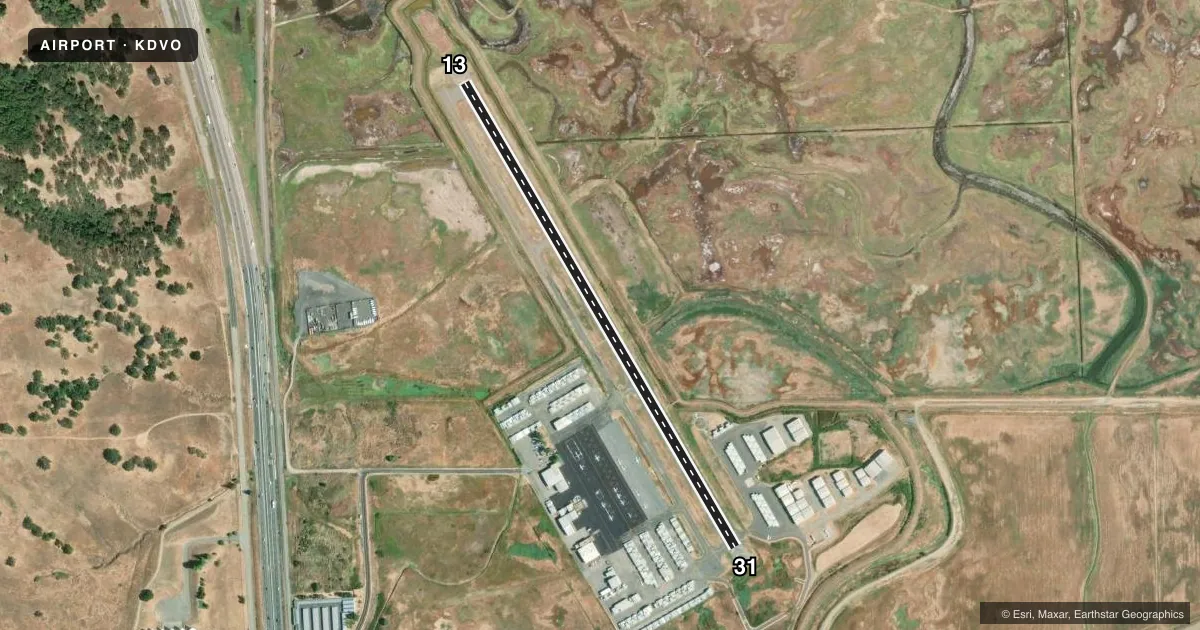
Runways & pattern
Full pagePattern entry · RWY 13
LEFT TRAFFICRunway end performance
| End | TORA | TODA | ASDA | LDA | VGSI | Approach lights | Obstruction |
|---|---|---|---|---|---|---|---|
| 13 | — | — | — | — | PAPI 2-box right(3.5°) | — | 82', tree, 3000' from thr, 0' R of cntrln, slope 34 |
| 31 | — | — | — | — | PAPI 2-box left(4°) | — | 180', hill, 4700' from thr, 500' R of cntrln, slope 25 |
Declared distances in feet. TORA = takeoff run available, TODA = takeoff distance, ASDA = accelerate-stop, LDA = landing distance.
Airport sketch
Runways drawn to scale from FAA survey coordinates, rendered over satellite imagery. Not for navigation.
Approaches & charts
Services on the field
Fuel grades, oxygen, maintenance, ramp storage and lighting — as declared to the FAA by the airport operator.
Fuel & services
- Fuel
- 100LLA
- Oxygen (bulk)
- HIGH/LOW
- Airframe repair
- Major
- Power plant repair
- Major
- Other services
- AVNCS,CHTR,INSTR,PAJA,RNTL,SALES
Ramp & ground
- Transient storage
- Tie-down
- Landing fee
- No fee published
- Customs
- Not available
- Beacon schedule
- SS-SR
- Beacon
- White / Green (civil land)(WG)
- Wind indicator
- Lighted
- Segmented circle
- Yes
Fuel & FBOs
Cheapest 100LL and Jet A on the field and nearby. Always confirm with the FBO before taxi.
Airport notes
Surface conditions, obstructions, local procedures, lighting outages and other notes published with each FAA cycle.
General notes
- DITCHES SURROUND RWY.
- MOUNTAINS W, HILLS S.
- NOISE SENSITIVE AREA SE OF ARPT. AVOID STRAIGHT - OUT DEPS ON RY 13 & STRAIGHT - IN LNDGS ON RY 31.
- RY 13 CALM WIND RY.
- JET AND TURBINE ACFT LAND RY 13 DEP RY 31 AS WIND AND TRAFFIC PERMIT.
- HELICOPTERS APCH FM EAST AND DEP TO EAST, REMAIN NORTH OF RADIO TOWERS.
- FOR CD CTC OAKLAND ARTCC AT 510-745-3380.
Runway surface & condition
- 13/31RY 13 HAS PAVED 125 FT OVERRUN. RY 31 HAS 100 FT OVERRUN.
- H1APPROACH 050/230 MAG
Other notes
- MANAGERDAN.JENSEN@MARINCOUNTY.GOV
VFR map & nearby airports
VFR sectional. Tap any ICAO chip to open that airport.
Key facts · KDVO
Answer card- ICAO
- KDVO
- Name
- GNOSS FLD
- Location
- NOVATO, CALIFORNIA
- Elevation
- 4 ft MSL
- Traffic pattern altitude
- 1,004 ft MSL (1,000 AGL)
- Control tower
- Non-towered (use CTAF)
- Total runways
- 1
- Longest runway
- 13/31 · 3,303 ft
- Published ILS approaches
- 0
- Published frequencies
- 2
- Magnetic variation
- 16°
- Current flight rules
- VFR
- Current wind
- 000° at 0 kt
- Favored runway now
- –
GNOSS FLD is in Novato, California. The field elevation is 4 ft MSL. It has one runway, 13/31, which is 3,303 ft long and paved with asphalt. There is no control tower. CTAF and UNICOM are both 123.075. No ILS approaches are published here.
The pattern altitude is not published in the facts. Use the current FAA Chart Supplement before you go. SkyShare is on the field. It carries 100LL, Jet A and Jet A Prist. For clearance delivery, Oakland ARTCC is listed in the remarks. The airport manager is Dan Jensen.
The published remarks matter here. Runway 13 is the calm wind runway. Jet and turbine aircraft land on 13 and depart 31 as wind and traffic permit. There is a noise sensitive area southeast of the airport. Avoid straight-out departures on 13. Avoid straight-in landings on 31. Mountains are west of the airport. Hills are south of the field. Ditches also surround the runway. Helicopters approach from the east and depart to the east. They stay north of the radio towers. For a first-time arrival, brief the runway overrun lengths and the terrain around the field before you launch.