METAR & TAF KAPC
Current METAR
Observed 12:54Z
KAPC 271254Z AUTO 33003KT 10SM CLR 11/10 A2999 RMK AO2 SLP147 T01060100
- Wind
- 330° @ 3 kt
- Visibility
- 10 SM
- Temp / Dew
- 11°C / 10°C
- Altimeter
- 29.99 inHg
- Clouds
- CLR
- Density alt
- -523 ft
- Ceiling
- Unlimited
- Rules
- VFR
Airport info & contacts
Manager on record, flight service, ARTCC, attendance schedule and pattern altitude — published by the FAA and refreshed every 28 days.
Location
- From city
- 5 NM S
- VFR sectional
- SAN FRANCISCO
- ARTCC
- ZOA · OAKLAND
- NOTAM facility
- APC (NOTAM-D)
Airport manager
- Name
- MARK WITSOE
- Phone
- 707-253-4300
- Address
- 2000 AIRPORT RD., NAPA CA 94558
Flight service · Hours
- FSS OAK
- OAKLAND1-800-WX-BRIEF
- Attendance
- 0700-2000
Frequencies
Tap any row to copy the frequency to your clipboard.
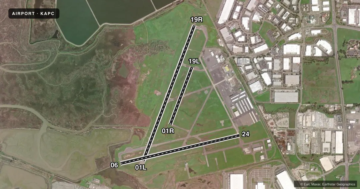
Runways & pattern
Full pagePattern entry · RWY 01L
LEFT TRAFFIC| Runway | Heading (°M) | Length | Surface | Traffic |
|---|---|---|---|---|
| 01L/19RFavored | 6° / 186° | 5,930 ft | ASPH | 19R R |
| 06/24 | 62° / 242° | 5,008 ft | CONC | Standard L |
| 01R/19L | 6° / 186° | 2,510 ft | ASPH | 01R R |
Runway end performance
| End | TORA | TODA | ASDA | LDA | VGSI | Approach lights | Obstruction |
|---|---|---|---|---|---|---|---|
| 01L | — | — | — | — | — | MALS | — |
| 19R | — | — | — | — | PAPI 4-box left(3.25°) | — | — |
Declared distances in feet. TORA = takeoff run available, TODA = takeoff distance, ASDA = accelerate-stop, LDA = landing distance.
Airport sketch
Runways drawn to scale from FAA survey coordinates, rendered over satellite imagery. Not for navigation.
Approaches & charts
ILS · 1
Services on the field
Fuel grades, oxygen, maintenance, ramp storage and lighting — as declared to the FAA by the airport operator.
Fuel & services
- Fuel
- 100LLA
- Oxygen (bottled)
- HIGH/LOW
- Oxygen (bulk)
- Not available
- Airframe repair
- Major
- Power plant repair
- Major
- Other services
- CHTR,INSTR,RNTL,SALES
Ramp & ground
- Transient storage
- Tie-down
- Landing fee
- Yes
- Customs
- Not available
- Lighting schedule
- SEE RMK
- Beacon schedule
- SS-SR
- Beacon
- White / Green (civil land)(WG)
- Wind indicator
- Lighted
- Segmented circle
- Yes
Fuel & FBOs
Cheapest 100LL and Jet A on the field and nearby. Always confirm with the FBO before taxi.
Airport notes
Surface conditions, obstructions, local procedures, lighting outages and other notes published with each FAA cycle.
General notes
- ASPH TWYS STRENGTH 30,000 GWT SINGLE WHEEL.
- ASPH APRONS STRENGTH 12500-30000 LBS GWT SINGLE WHEEL.
- UNLGTD BRIDGE 1 NM S, 167 FT AGL
- DUE TO AIRPORT PROXIMITY TO WETLANDS BIRDS ON AND INVOF THE AIRPORT YEAR AROUND WITH HIGHEST CONCENTRATION OF ACTIVITY OF BIRDS ON THE RYS DURING RAINY WEATHER.
- FOR CD WHEN ATCT CLSD CTC OAKLAND ARTCC AT 510-745-3380.
Lighting notes
- WHEN ATCT CLSD ACTVT MALS RWY 01L; REIL RWY 06; MIRL RWYS 01L/19R & RWY 06/24 - CTAF. PAPI RWY 19R OPR CONSLY.
Fuel notes
- 100LLFOR FUEL SVC 2100-0600 CALL 707-224-0887.
Other notes
- LDG FEE CHRGD TO ALL AIR TAXI, COML ACFT OPNS (EXCLDG FLT INSTRUCTION), AND TSNT ACFT WEIGHING MORE THAN 12500 LBS.
VFR map & nearby airports
VFR sectional. Tap any ICAO chip to open that airport.
Key facts · KAPC
Answer card- ICAO
- KAPC
- Name
- NAPA COUNTY
- Location
- NAPA, CALIFORNIA
- Elevation
- 35.5 ft MSL
- Traffic pattern altitude
- 1,035.5 ft MSL (1,000 AGL)
- Control tower
- Towered · 0700-2000
- Total runways
- 3
- Longest runway
- 01L/19R · 5,930 ft
- Published ILS approaches
- 1
- Published frequencies
- 8
- Magnetic variation
- 15°
- Current flight rules
- VFR
- Current wind
- 330° at 3 kt
- Favored runway now
- RWY 01L
Napa County Airport sits in Napa, California. Field elevation is 35.5 ft MSL. The airport has 3 runways. The longest is 5,930 ft on 01L/19R. The control tower is open 0700-2000. One ILS is published for runway 01L. Pattern altitude is not published, so use standard 1,000 ft AGL for light piston unless the current Chart Supplement says otherwise.
This is a low-elevation field near wetlands. Bird activity is a real factor here, especially in rainy weather. There is also an unlighted bridge about 1 NM south that sits 167 ft AGL, so keep that in mind on departure and arrival. When the tower is closed, runway lighting can be activated by CTAF. The published remarks also note that PAPI on 19R operates continuously.
Atlantic Aviation is on the field. It carries 100LL and Jet A. Skyservice is also on the field. It carries 100LL, Jet A and Jet A Prist. If you need fuel after hours, the published remarks say to call Atlantic Aviation at 707-224-0887 for service from 2100 to 0600. For clearance delivery when the tower is closed, contact Oakland ARTCC. Check the current Chart Supplement for any noise or operating restrictions before you go.