METAR & TAF KMYV
Current METAR
Observed 23:53Z
KMYV 232353Z AUTO 20006KT 10SM CLR 34/07 A2989 RMK AO2 SLP126 T03440067 10344 20239 56019 $
- Wind
- 200° @ 6 kt
- Visibility
- 10 SM
- Temp / Dew
- 34°C / 7°C
- Altimeter
- 29.89 inHg
- Clouds
- CLR
- Density alt
- 2,397 ft
- Ceiling
- Unlimited
- Rules
- VFR
Airport info & contacts
Manager on record, flight service, ARTCC, attendance schedule and pattern altitude — published by the FAA and refreshed every 28 days.
Location
- From city
- 3 NM SE
- VFR sectional
- SAN FRANCISCO
- Pattern altitude
- 400 ft AGL · 464 ft MSL
- ARTCC
- ZOA · OAKLAND
- NOTAM facility
- MYV (NOTAM-D)
Airport manager
- Name
- JASON KOPPING
- Phone
- 530-749-7800
- Address
- 1364 SKY HARBOR DRIVE, OLIVEHURST CA 95961
Flight service · Hours
- FSS RIU
- RANCHO MURIETA1-800-WX-BRIEF
- Attendance
- 0600-1800
Frequencies
Tap any row to copy the frequency to your clipboard.
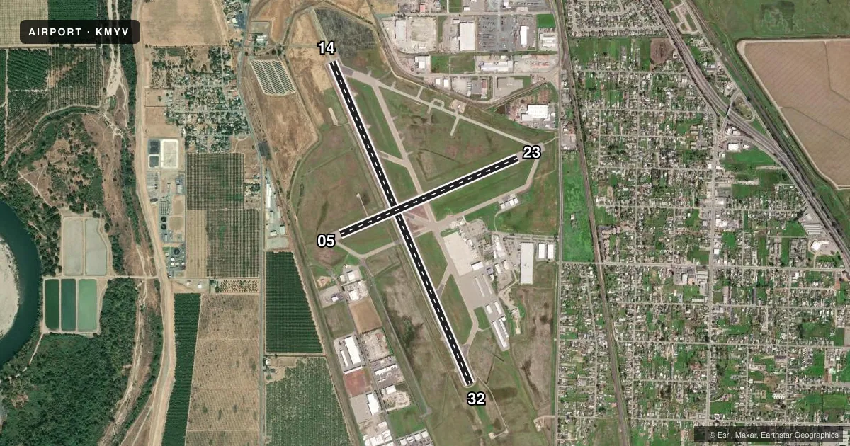
Runways & pattern
Full pagePattern entry · RWY 14
LEFT TRAFFIC| Runway | Heading (°M) | Length | Surface | Traffic |
|---|---|---|---|---|
| 14/32Favored | 141° / 321° | 6,007 ft | ASPH | Standard L |
| 05/23 | 51° / 231° | 3,314 ft | ASPH | Standard L |
Runway end performance
| End | TORA | TODA | ASDA | LDA | VGSI | Approach lights | Obstruction |
|---|---|---|---|---|---|---|---|
| 14 | — | — | — | — | VASI 4-box left(3°) | MALSR | 65', tree, 3200' from thr, 300' R of cntrln, slope 44 |
| 32 | — | — | — | — | VASI 4-box left(3°) | — | 39', pole, 1750' from thr, 175' R of cntrln, slope 39 |
| 05 | — | — | — | — | — | — | 25', rr, 800' from thr, 200' R of cntrln, slope 24 |
| 23 | — | — | — | — | — | — | 45', tree, 900' from thr, 50' R of cntrln, slope 15 |
Declared distances in feet. TORA = takeoff run available, TODA = takeoff distance, ASDA = accelerate-stop, LDA = landing distance.
Airport sketch
Runways drawn to scale from FAA survey coordinates, rendered over satellite imagery. Not for navigation.
Approaches & charts
ILS · 1
Services on the field
Fuel grades, oxygen, maintenance, ramp storage and lighting — as declared to the FAA by the airport operator.
Fuel & services
- Fuel
- 100LLA
- Oxygen (bottled)
- Not available
- Oxygen (bulk)
- Not available
- Airframe repair
- Major
- Power plant repair
- Minor
- Other services
- AFRT,AMB,INSTR,RNTL
Ramp & ground
- Transient storage
- Tie-down
- Hangar
- Landing fee
- No fee published
- Customs
- Not available
- Lighting schedule
- SEE RMK
- Beacon schedule
- SS-SR
- Beacon
- White / Green (civil land)(WG)
- Wind indicator
- Yes
- Segmented circle
- Yes
Fuel & FBOs
Cheapest 100LL and Jet A on the field and nearby. Always confirm with the FBO before taxi.
Airport notes
Surface conditions, obstructions, local procedures, lighting outages and other notes published with each FAA cycle.
General notes
- RY 23 +35 FT PLINES 900-1050 FT FM RY END; RUNNING 145 FT LEFT TO 210 FT RIGHT.
- MIGRATORY FLOCKS OF WATERFOWL IN VICINITY OF AIRPORT DURING THE SPRING AND FALL OF THE YEAR.
- FOR CD CTC NORCAL APCH AT 916-361-6874.
- RGLR ULTRALIGHT AND PWRD PRCHT OPS NORTH OF RWY 5/23 AND EAST OF RWY 14/32. ULTRALIGHT ARRS AND DEPS ARE FROM THE WEST. FOR ADDNL DETAILS ON LOCAL PROCS CALL 530-749-7801.
Lighting notes
- ACTVT MALSR RWY 14; VASI RWY 14 & 32, HIRL RWY 14/32 - CTAF
Approach & departure obstructions
- 05MRKGS ARE FADED.
- 23MRKGS ARE FADED.
Other notes
- TPA FOR ULTRALIGHTS.
- 05/23RWY 5/23 ASPH SFC IS IN POOR COND WITH RAVELING AND SPALLING ASPH, AND LONGL AND LATERAL CRACKING.
VFR map & nearby airports
VFR sectional. Tap any ICAO chip to open that airport.
Key facts · KMYV
Answer card- ICAO
- KMYV
- Name
- YUBA COUNTY
- Location
- MARYSVILLE, CALIFORNIA
- Elevation
- 64.3 ft MSL
- Traffic pattern altitude
- 464.3 ft MSL (400 AGL)
- Control tower
- Non-towered (use CTAF)
- Total runways
- 2
- Longest runway
- 14/32 · 6,007 ft
- Published ILS approaches
- 1
- Published frequencies
- 4
- Magnetic variation
- 16°
- Current flight rules
- VFR
- Current wind
- 200° at 6 kt
- Favored runway now
- RWY 14
Yuba County Airport is in Marysville, California. Field elevation is 64.3 ft MSL. The airport has two asphalt runways. The longest is runway 14/32 at 6,007 ft. There is no control tower, so expect CTAF self-announce traffic on 123.05.
Runway 14 has the ILS. The field also has MALSR on 14. VASI is available on runways 14 and 32. High intensity runway lights are on 14 and 32. Pattern altitude is not published in the facts. Use the standard 1,000 ft AGL for light piston unless the current FAA Chart Supplement says otherwise.
Honeycutt Aviation is on the field. It carries 100LL, Jet A and Jet A Prist. For clearance delivery, contact NorCal Approach at the number in the Chart Supplement or use the published approach frequencies. First-time pilots should pay attention to the runway 5/23 surface condition. The facts note poor asphalt with raveling, spalling and cracking. Markings on 05 and 23 are faded. Runway 23 also has power lines beyond the departure end. Migratory waterfowl are reported in the area in spring and fall. Keep a sharp scan on arrival and departure.