METAR & TAF KAUN
Current METAR
Observed 01:15Z
KAUN 270115Z AUTO 00000KT 10SM CLR 32/05 A2998 RMK A01
- Wind
- 000° @ 0 kt
- Visibility
- 10 SM
- Temp / Dew
- 32°C / 5°C
- Altimeter
- 29.98 inHg
- Clouds
- CLR
- Density alt
- 3,873 ft
- Ceiling
- Unlimited
- Rules
- VFR
Airport info & contacts
Manager on record, flight service, ARTCC, attendance schedule and pattern altitude — published by the FAA and refreshed every 28 days.
Location
- From city
- 3 NM N
- VFR sectional
- SAN FRANCISCO
- ARTCC
- ZOA · OAKLAND
- NOTAM facility
- AUN (NOTAM-D)
Airport manager
- Name
- TYGHE RICHARDSON
- Phone
- 530-888-8174
- Address
- 1225 LINCOLN WAY, AUBURN CA 95603
Flight service · Hours
- FSS RIU
- RANCHO MURIETA1-800-WX-BRIEF
- Attendance
- 0800-1800
Frequencies
Tap any row to copy the frequency to your clipboard.
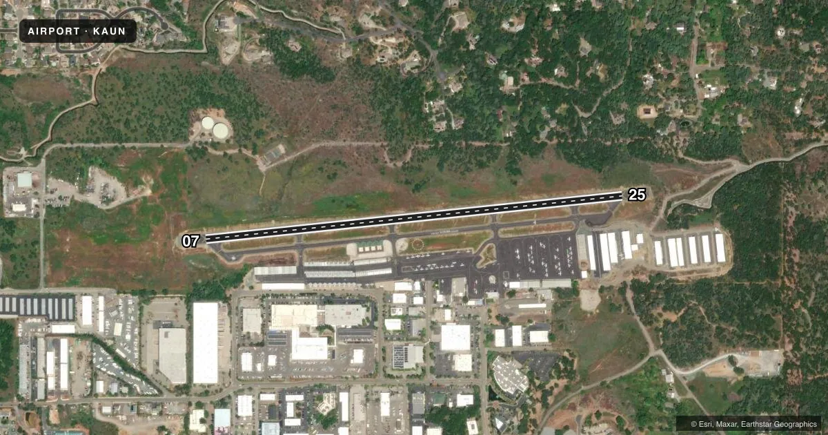
Runways & pattern
Full pagePattern entry · RWY 07
LEFT TRAFFICRunway end performance
| End | TORA | TODA | ASDA | LDA | VGSI | Approach lights | Obstruction |
|---|---|---|---|---|---|---|---|
| 07 | — | — | — | — | PAPI 2-box left(3°) | — | 4', hill, 342' from thr, 0' R of cntrln, slope 35 |
| 25 | — | — | — | — | PAPI 2-box left(3.5°) | — | 10', hill, 425' from thr, 90' R of cntrln, slope 22 |
Declared distances in feet. TORA = takeoff run available, TODA = takeoff distance, ASDA = accelerate-stop, LDA = landing distance.
Airport sketch
Runways drawn to scale from FAA survey coordinates, rendered over satellite imagery. Not for navigation.
Approaches & charts
Services on the field
Fuel grades, oxygen, maintenance, ramp storage and lighting — as declared to the FAA by the airport operator.
Fuel & services
- Fuel
- 100LLAA1
- Oxygen (bottled)
- HIGH/LOW
- Oxygen (bulk)
- HIGH/LOW
- Airframe repair
- Major
- Power plant repair
- Major
- Other services
- AVNCS,CHTR,INSTR,RNTL
Ramp & ground
- Transient storage
- Tie-down
- Hangar
- Landing fee
- Yes
- Customs
- Not available
- Lighting schedule
- SEE RMK
- Beacon schedule
- SS-SR
- Beacon
- White / Green (civil land)(WG)
- Wind indicator
- Lighted
- Segmented circle
- Yes
Fuel & FBOs
Cheapest 100LL and Jet A on the field and nearby. Always confirm with the FBO before taxi.
Airport notes
Surface conditions, obstructions, local procedures, lighting outages and other notes published with each FAA cycle.
General notes
- FUEL 100LL & JET A AVAILABLE 24 HRS.
- ULTRALIGHT ACTIVITY ON AND INVOF ARPT.
- FOR CD CTC NORCAL APCH AT 916-361-6874.
- NOISE ABATEMENT ALL DEPS MIN PWR WHILE OBSG SAFE ACFT OPS.
- NOISE: VFR NOISE ABATEMENT PROCS: RWY 25 NO STRAIGHT OUT VFR DEP. AT END OF RWY TRACK 230 DEG OVER SELF-STORAGE FAC TO AVOID NOISE SENSITIVE AREAS. TURN ON CRS AFTER REACHING 2500 MSL. RWY 07 TURN ON CRS AFTER REACHING 2500 MSL. AVOID NOISE SENSITIVE AREAS. SEE NOISE ABATEMENT BROCHURE.
- TSNT PRKG T'S ARE PAINTED BLUE.
Lighting notes
- ACTVT MIRL RWY 07/25 - CTAF. PAPI RWY 7 & RWY 25 OPER CONSLY.
Approach & departure obstructions
- 07HEL RIGHT TFC FOR RWY 07.
- 25PAPI UNUSBL BYD 5 DEG LEFT OF CNTRLN
Other notes
- REFER TO ARPT WEBSITE FOR OVNGT PRKG FEES.
- HEL TFC PAT 580 FT AGL.
VFR map & nearby airports
VFR sectional. Tap any ICAO chip to open that airport.
Key facts · KAUN
Answer card- ICAO
- KAUN
- Name
- AUBURN MUNI
- Location
- AUBURN, CALIFORNIA
- Elevation
- 1,538.2 ft MSL
- Traffic pattern altitude
- 2,538.2 ft MSL (1,000 AGL)
- Control tower
- Non-towered (use CTAF)
- Total runways
- 1
- Longest runway
- 07/25 · 3,700 ft
- Published ILS approaches
- 0
- Published frequencies
- 4
- Magnetic variation
- 16°
- Current flight rules
- VFR
- Current wind
- 000° at 0 kt
- Favored runway now
- –
Auburn Muni sits in Auburn, California. The field elevation is 1,538.2 ft MSL. It has one runway, 07/25, which is 3,700 ft long. This is a non-towered field, so plan on self-announce traffic on CTAF 122.7. No ILS approaches are published here.
The published pattern altitude is not given for light piston traffic. Use the standard 1,000 ft AGL unless the current Chart Supplement says otherwise. Helicopter pattern altitude is published at 580 ft AGL. Threshold Aviation is on the field. It carries 100LL, Jet A and Jet A Prist. Fuel is available 24 hours. Transient parking tie-downs are painted blue.
Auburn sees ultralight activity on and near the airport. Noise abatement matters here. Departures are expected to use minimum power while staying within safe operating limits. Runway 25 has no straight-out VFR departure. From runway 25, track 230 degrees over the self-storage facility. Turn on course after reaching 2,500 ft MSL. From runway 07, turn on course after reaching 2,500 ft MSL. The PAPI on runway 25 is unusable beyond 5 degrees left of centerline. Medium intensity runway lights are CTAF-activated. For clearance delivery, contact NorCal Approach at 916-361-6874.