METAR & TAF KPVF
Current METAR
Observed 08:15Z
KPVF 270815Z AUTO 00000KT 10SM CLR 22/04 A3007 RMK AO1
- Wind
- 000° @ 0 kt
- Visibility
- 10 SM
- Temp / Dew
- 22°C / 4°C
- Altimeter
- 30.07 inHg
- Clouds
- CLR
- Density alt
- 3,860 ft
- Ceiling
- Unlimited
- Rules
- VFR
Airport info & contacts
Manager on record, flight service, ARTCC, attendance schedule and pattern altitude — published by the FAA and refreshed every 28 days.
Location
- From city
- 3 NM E
- VFR sectional
- SAN FRANCISCO
- Pattern altitude
- 800 ft AGL · 3,386 ft MSL
- ARTCC
- ZOA · OAKLAND
- NOTAM facility
- RIU (NOTAM-D)
Airport manager
- Name
- DALE LUSBY
- Phone
- 530-622-0459
- Address
- 3501 AIRPORT RD. SUITE 1, SUITE 1, PLACERVILLE CA 95667
Flight service · Hours
- FSS RIU
- RANCHO MURIETA1-800-WX-BRIEF
- Attendance
- MON-SAT · 0800-1700
Frequencies
Tap any row to copy the frequency to your clipboard.
Runways & pattern
Full pagePattern entry · RWY 05
RIGHT TRAFFICRunway end performance
| End | TORA | TODA | ASDA | LDA | VGSI | Approach lights | Obstruction |
|---|---|---|---|---|---|---|---|
| 05 | — | — | — | — | VASI 4-box left(3°) | — | — |
| 23 | — | — | — | — | PAPI 2-box left(3.75°) | — | — |
Declared distances in feet. TORA = takeoff run available, TODA = takeoff distance, ASDA = accelerate-stop, LDA = landing distance.
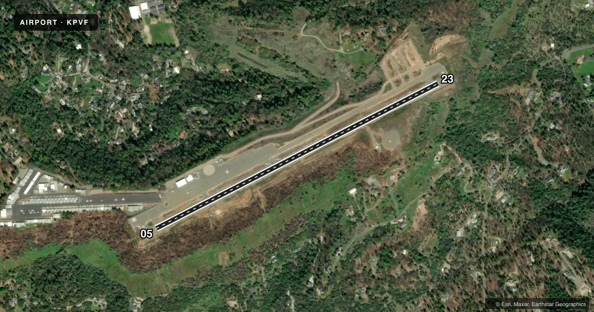
Airport sketch
Runways drawn to scale from FAA survey coordinates, rendered over satellite imagery. Not for navigation.
Approaches & charts
Services on the field
Fuel grades, oxygen, maintenance, ramp storage and lighting — as declared to the FAA by the airport operator.
Fuel & services
- Fuel
- 100LLA
- Oxygen (bottled)
- Not available
- Oxygen (bulk)
- Not available
- Airframe repair
- Major
- Power plant repair
- Major
- Other services
- INSTR,RNTL,SALES
Ramp & ground
- Transient storage
- Tie-down
- Landing fee
- No fee published
- Customs
- Not available
- Lighting schedule
- SEE RMK
- Beacon schedule
- SS-SR
- Beacon
- White / Green (civil land)(WG)
- Wind indicator
- Lighted
- Segmented circle
- Yes
Fuel & FBOs
Cheapest 100LL and Jet A on the field and nearby. Always confirm with the FBO before taxi.
Airport notes
Surface conditions, obstructions, local procedures, lighting outages and other notes published with each FAA cycle.
General notes
- PPR FOR TGL FOR ACFT OVER 12500 LBS.
- HELO PARKING AT NE END OF RY.
- NOISE ABATEMENT PROCEDURE: NO MID-FIELD DEPS; NO TURNS WEST OR NORTH PRIOR TO 3400 MSL OR CLEAR OF NOISE SENSITIVE AREA. RY 23 AFTER TKOF MAKE 10 DEG LEFT TURN AT EOR TO AVOID NOISE SENSITIVE RESIDENTIAL AREAS.
- DEER ON AND INVOF RY ESPECIALLY NGTS.
- HELIPAD LCTD ON NORTH SIDE OF RY 05 END.
- TREES 750 FT N RWY 5/23 2697 FT MSL (110FT AGL) NOT LGTD.
- FOR CD CTC NORCAL APCH AT 916-361-6874.
Lighting notes
- ACTVT VASI RWY 05; PAPI RWY 23; MIRL RWY 05/23 - CTAF.
Fuel notes
- 100LLFUEL AVBL 24 HOURS BY CREDIT CARD.
- AFULL SVC TRUCK TUE-SAT 0800-1200 & 1300-1700.
VFR map & nearby airports
VFR sectional. Tap any ICAO chip to open that airport.
Key facts · KPVF
Answer card- ICAO
- KPVF
- Name
- PLACERVILLE
- Location
- PLACERVILLE, CALIFORNIA
- Elevation
- 2,585.8 ft MSL
- Traffic pattern altitude
- 3,385.8 ft MSL (800 AGL)
- Control tower
- Non-towered (use CTAF)
- Total runways
- 1
- Longest runway
- 05/23 · 3,914 ft
- Published ILS approaches
- 0
- Published frequencies
- 4
- Magnetic variation
- 14°
- Current flight rules
- VFR
- Current wind
- 000° at 0 kt
- Favored runway now
- –
Placerville Airport sits in Placerville, California. Field elevation is 2,585.8 ft MSL. The airport has one runway, 05/23, which is 3,914 ft long on asphalt. It is an untowered field. NorCal Approach handles approach and departure services on 127.4 and 317.5. CTAF and UNICOM are both 122.8.
Pattern altitude is 800 ft AGL. That puts the pattern at 3,385.8 ft MSL. There are no ILS approaches published here. The on-field FBO is Placerville Airport. It carries AVGAS 100LL and JET A. 100LL is available 24 hours by credit card. Full service Jet A truck service is listed Tuesday through Saturday during the morning and afternoon windows in the Chart Supplement.
This is a mountain area airport with a high field elevation. Expect density altitude to matter, especially on warm days. The published remarks also call out deer on and near the runway, especially at night. Noise abatement is specific here. No midfield departures. No turns west or north before 3,400 ft MSL or clear of the noise sensitive area. After takeoff from runway 23, make a 10 degree left turn at the end of the runway to avoid residential areas. Trees are also published north of the runway. Check your departure path and climb performance before you go.