METAR & TAF O41
O41 does not publish a METAR.
Showing the nearest reporting station: KDWA (YOLO COUNTY) · 5.7 NM away. Conditions at O41 may differ.
METAR · KDWA
Observed 19:15Z
KDWA 261915Z AUTO 00000KT 10SM CLR 30/11 A2999 RMK AO2
- Wind
- 000° @ 0 kt
- Visibility
- 10 SM
- Temp / Dew
- 30°C / 11°C
- Altimeter
- 29.99 inHg
- Clouds
- CLR
- Density alt
- 1,868 ft
- Ceiling
- Unlimited
- Rules
- VFR
Airport info & contacts
Manager on record, flight service, ARTCC, attendance schedule and pattern altitude — published by the FAA and refreshed every 28 days.
Location
- From city
- 4 NM W
- VFR sectional
- SAN FRANCISCO
- ARTCC
- ZOA · OAKLAND
- NOTAM facility
- RIU (NOTAM-D)
Airport manager
- Name
- MILTON B. WATTS
- Phone
- 530-867-6652
- Address
- 17992 COUNTY ROAD 94B, WOODLAND CA 95695
Flight service · Hours
- FSS RIU
- RANCHO MURIETA1-800-WX-BRIEF
- Attendance
- OCT-APR · 0800-1700
- MAY-SEP · 0700-1800
Frequencies
Tap any row to copy the frequency to your clipboard.
Runways & pattern
Full pagePattern entry · RWY 18
LEFT TRAFFICRunway end performance
| End | TORA | TODA | ASDA | LDA | VGSI | Approach lights | Obstruction |
|---|---|---|---|---|---|---|---|
| 18 | 3,759' | 3,759' | 3,559' | 2,929' | — | — | 36', trees, 600' from thr, 209' R of cntrln, slope 11 |
| 36 | 3,759' | 3,759' | 3,629' | 3,244' | — | — | 20', ant, 300' from thr, 100' R of cntrln, slope 5 |
Declared distances in feet. TORA = takeoff run available, TODA = takeoff distance, ASDA = accelerate-stop, LDA = landing distance.
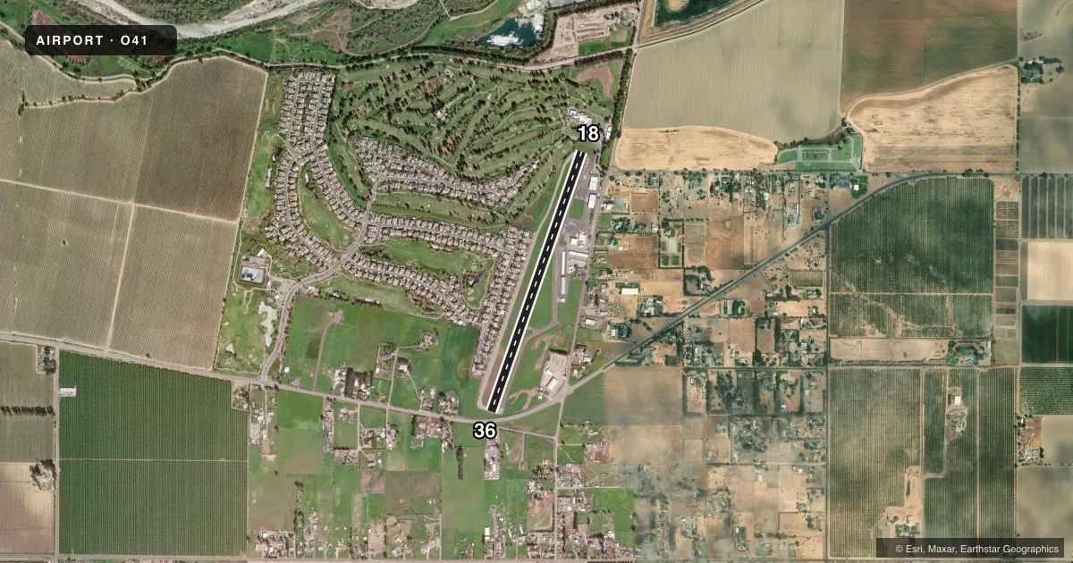
Airport sketch
Runways drawn to scale from FAA survey coordinates, rendered over satellite imagery. Not for navigation.
Approaches & charts
Services on the field
Fuel grades, oxygen, maintenance, ramp storage and lighting — as declared to the FAA by the airport operator.
Fuel & services
- Fuel
- 100LL
- Oxygen (bottled)
- HIGH/LOW
- Oxygen (bulk)
- Not available
- Airframe repair
- Major
- Power plant repair
- Major
- Other services
- INSTR,RNTL,SALES
Ramp & ground
- Transient storage
- Tie-down
- Hangar
- Customs
- Not available
- Lighting schedule
- SEE RMK
- Beacon schedule
- SS-SR
- Beacon
- White / Green (civil land)(WG)
- Wind indicator
- Lighted
- Segmented circle
- No
Fuel & FBOs
Cheapest 100LL and Jet A on the field and nearby. Always confirm with the FBO before taxi.
Airport notes
Surface conditions, obstructions, local procedures, lighting outages and other notes published with each FAA cycle.
General notes
- TWIN ENGINE ACFT BACK TAXI ON RY.
- RY 18 UNLGTD 60 FT TREES HIGHER THAN POLE MOUNTED OBSTN LGTS.
- FOR CD CTC OAKLAND ARTCC AT 510-745-3380.
Lighting notes
- ACTVT MIRL RY 18/36 - CTAF.
Fuel notes
- 100LLFUEL 24 HRS WITH CREDIT CARD.
Runway surface & condition
- 18/36GROSS PAVEMENT STRENGTH PRVDD BY MGR; 12000 LBS.
Approach & departure obstructions
- 18+15 FT ROAD 125 FT FM EOR AND +20 FT BUSHES AND TREE 100 FT RIGHT 75 FT FM EOR.
- 36RWY 36 +4' FENCE 55' & ROAD 80' FROM THR.
- 18SVRLY FADED RWY MRKGS.
- 36SVRLY FADED RWY MRKGS.
- 18RWY 18 APCH RATIO 34:1 TO DSPLCD THLD.
- 36RY 36 APCH RATIO 34:1 TO DSPLCD THLD.
Other notes
- THIS AIRPORT HAS BEEN SURVEYED BY THE NATIONAL GEODETIC SURVEY.
- ESTABD PRIOR TO 15 MAY 1959.
- TPA FOR TURBINE ACFT 1500 FT AGL; TPA FOR OTHER ACFT 1000 FT AGL.
VFR map & nearby airports
VFR sectional. Tap any ICAO chip to open that airport.
Key facts · O41
Answer card- ICAO
- O41
- Name
- WATTS-WOODLAND
- Location
- WOODLAND, CALIFORNIA
- Elevation
- 125 ft MSL
- Traffic pattern altitude
- 1,125 ft MSL (1,000 AGL)
- Control tower
- Non-towered (use CTAF)
- Total runways
- 1
- Longest runway
- 18/36 · 3,759 ft
- Published ILS approaches
- 0
- Published frequencies
- 4
- Magnetic variation
- 14°
- Current flight rules
- VFR
- Current wind
- 000° at 0 kt
- Favored runway now
- –
Watts-Woodland Airport (O41) sits in Woodland, California. The field elevation is 125 ft MSL. It has one runway, 18/36, which is 3,759 ft long. There is no control tower. CTAF and UNICOM are both 122.8. Approach and departure service is on Travis frequencies. No ILS approaches are published here.
The pattern altitude is not published. Use 1,000 ft AGL for light piston operations unless the current FAA Chart Supplement says otherwise. The on-field FBO is Watts-Woodland Airport. It carries 100LL and Jet A. Fuel is available 24 hours with credit card.
A few runway notes matter here. Runway 18 is unlighted in the remarks, though medium intensity runway lights on 18/36 are activated by CTAF. Runway 18 also has severely faded markings. Runway 36 has severely faded markings too. The remarks also note trees near the 18 end, plus a fence and road near the 36 threshold. Twin-engine aircraft are told to back taxi on the runway. Gross pavement strength is listed at 12,000 pounds. If you are planning a night or low-visibility arrival, verify the lighting and runway condition before you go. This is a non-towered field, so expect self-announce traffic and stay sharp on the pattern.