METAR & TAF KDWA
Current METAR
Observed 15:55Z
KDWA 261555Z AUTO 00000KT 10SM CLR 20/13 A2999 RMK AO2
- Wind
- 000° @ 0 kt
- Visibility
- 10 SM
- Temp / Dew
- 20°C / 13°C
- Altimeter
- 29.99 inHg
- Clouds
- CLR
- Density alt
- 637 ft
- Ceiling
- Unlimited
- Rules
- VFR
Airport info & contacts
Manager on record, flight service, ARTCC, attendance schedule and pattern altitude — published by the FAA and refreshed every 28 days.
Location
- From city
- 6 NM NE
- VFR sectional
- SAN FRANCISCO
- ARTCC
- ZOA · OAKLAND
- NOTAM facility
- RIU (NOTAM-D)
Airport manager
- Name
- RYAN PISTOCHINI
- Phone
- 530-406-5044
- Address
- 120 WEST MAIN, SUITE G, RM 202, WOODLAND CA 95695-2598
Flight service · Hours
- FSS RIU
- RANCHO MURIETA1-800-WX-BRIEF
- Attendance
- 0600-1800
Frequencies
Tap any row to copy the frequency to your clipboard.
Runways & pattern
Full pagePattern entry · RWY 16
RIGHT TRAFFICRunway end performance
| End | TORA | TODA | ASDA | LDA | VGSI | Approach lights | Obstruction |
|---|---|---|---|---|---|---|---|
| 16 | — | — | — | — | PAPI 2-box left(3°) | — | — |
| 34 | — | — | — | — | PAPI 2-box left(3°) | — | 110', trees, 3500' from thr, 0' R of cntrln, slope 30 |
Declared distances in feet. TORA = takeoff run available, TODA = takeoff distance, ASDA = accelerate-stop, LDA = landing distance.
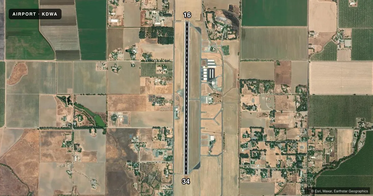
Airport sketch
Runways drawn to scale from FAA survey coordinates, rendered over satellite imagery. Not for navigation.
Approaches & charts
Services on the field
Fuel grades, oxygen, maintenance, ramp storage and lighting — as declared to the FAA by the airport operator.
Fuel & services
- Fuel
- 100LLAA+
- Oxygen (bottled)
- HIGH/LOW
- Oxygen (bulk)
- HIGH/LOW
- Airframe repair
- Major
- Power plant repair
- Major
- Other services
- AGRI,AVNCS,CHTR,INSTR,PAJA,SALES
Ramp & ground
- Transient storage
- Tie-down
- Landing fee
- No fee published
- Customs
- Not available
- Lighting schedule
- SEE RMK
- Beacon schedule
- SS-SR
- Beacon
- White / Green (civil land)(WG)
- Wind indicator
- Lighted
- Segmented circle
- Yes
Fuel & FBOs
Cheapest 100LL and Jet A on the field and nearby. Always confirm with the FBO before taxi.
Airport notes
Surface conditions, obstructions, local procedures, lighting outages and other notes published with each FAA cycle.
General notes
- NO TGL 2200L TO 0600L.
- RY 34 CALM WIND RY.
- NOISE ABATEMENT: NO TURNS TO CROSSWIND PRIOR TO ARPT BOUNDARY. STRAIGHT OUT DEP NO EAST TURNS ON COURSE PRIOR TO 2 MIS. AVOID OVERFLIGHT OF OFF-ARPT STRUCTURES.
- UNLIT 40 FT POWER LINE & 120 FT TREES 500 FT WEST OF RY CNTRLN.
- BIRDS ON AND INVOF ARPT.
- PARACHUTE ACTIVITY EAST OF RY.
- CROP DUSTER OPNS ON AND INVOF ARPT.
- NON-RADIO AIRCRAFT BASED AT KDWA.
- 95 FT AGL UNLIT WIND TURBINE 1000 FT WEST OF RY CNTRLN.
- APT OPS: (530) 759-8766
- FOR CD CTC OAKLAND ARTCC AT 510-745-3380.
Lighting notes
- MIRL RY 16/34 PRESET LOW INTST; TO INCR INTST AND ACTVT PAPI RYS 16 & 34 - CTAF.
Fuel notes
- 100LLFUEL AVBL 24 HRS.
Other notes
- DSTC TO WINTERS.
VFR map & nearby airports
VFR sectional. Tap any ICAO chip to open that airport.
Key facts · KDWA
Answer card- ICAO
- KDWA
- Name
- YOLO COUNTY
- Location
- DAVIS/WOODLAND/WINTERS, CALIFORNIA
- Elevation
- 100 ft MSL
- Traffic pattern altitude
- 1,100 ft MSL (1,000 AGL)
- Control tower
- Non-towered (use CTAF)
- Total runways
- 1
- Longest runway
- 16/34 · 6,000 ft
- Published ILS approaches
- 0
- Published frequencies
- 4
- Magnetic variation
- 16°
- Current flight rules
- VFR
- Current wind
- 000° at 0 kt
- Favored runway now
- –
YOLO COUNTY (KDWA) sits in the Davis, Woodland, Winters area of California. The field elevation is 100 ft MSL. It has one runway, 16/34, which is 6,000 ft long. There is no control tower. No ILS approaches are published here.
Pattern altitude is not published. Use 1,000 ft AGL for light piston traffic unless the current FAA Chart Supplement says otherwise. The airport sits in busy low-altitude airspace with Travis approach and departure frequencies in use. Expect mixed traffic. Parachute activity is east of the runway. Crop duster operations are also on and near the airport. Birds are reported in the area too.
Two on-field FBOs are listed. PreStar/SkyDance SkyDiving carries 100LL and Jet A. Davis Flight Support carries 100LL, Jet A and Jet A Prist. 100LL is available 24 hours. The airport operations phone number is (530) 759-8766. Runway 34 is the calm wind runway. There is an unlit 40-foot power line and 120-foot trees about 500 feet west of the runway centerline. A 95-foot unlit wind turbine is also about 1,000 feet west of centerline. Night or low-visibility operations deserve extra attention here. The published noise abatement asks for no crosswind turn before the airport boundary. Depart straight out with no east turns on course before 2 miles. No touch-and-go operations are allowed from 2200 local to 0600 local.