METAR & TAF KSVE
Current METAR
Observed 10:55Z
KSVE 271055Z AUTO 00000KT 10SM CLR 10/M02 A3016 RMK A01 P000
- Wind
- 000° @ 0 kt
- Visibility
- 10 SM
- Temp / Dew
- 10°C / -2°C
- Altimeter
- 30.16 inHg
- Clouds
- CLR
- Density alt
- 4,247 ft
- Ceiling
- Unlimited
- Rules
- VFR
Airport info & contacts
Manager on record, flight service, ARTCC, attendance schedule and pattern altitude — published by the FAA and refreshed every 28 days.
Location
- From city
- 5 NM SE
- VFR sectional
- KLAMATH FALLS
- Pattern altitude
- 800 ft AGL · 4,949 ft MSL
- ARTCC
- ZOA · OAKLAND
- NOTAM facility
- SVE (NOTAM-D)
Airport manager
- Name
- STEVE DATAMA
- Phone
- 530-257-2030
- Address
- 471-920 JOHNSTONVILLE ROAD #10, SUSANVILLE CA 96130
Flight service · Hours
- FSS RNO
- RENO1-800-WX-BRIEF
- Attendance
- 0800-1700
Frequencies
Tap any row to copy the frequency to your clipboard.
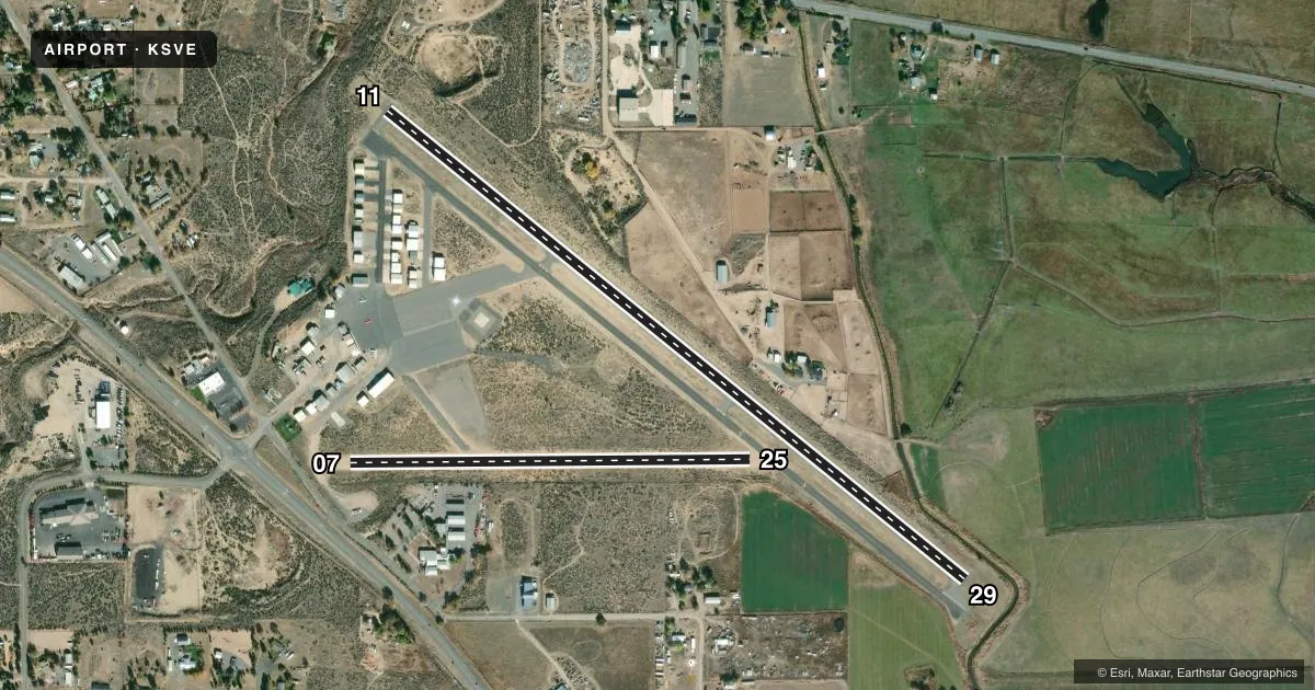
Runways & pattern
Full pagePattern entry · RWY 11
LEFT TRAFFIC| Runway | Heading (°M) | Length | Surface | Traffic |
|---|---|---|---|---|
| 11/29 | 112° / 292° | 4,051 ft | ASPH | 29 R |
| 07/25 | 72° / 252° | 2,180 ft | DIRT | Standard L |
Runway end performance
| End | TORA | TODA | ASDA | LDA | VGSI | Approach lights | Obstruction |
|---|---|---|---|---|---|---|---|
| 11 | — | — | — | — | PAPI 2-box left(3°) | — | 70', trees, 1650' from thr, 125' R of cntrln, slope 20 |
| 29 | — | — | — | — | PAPI 2-box left(4°) | — | — |
| 07 | — | — | — | — | — | — | 5', fence, 60' from thr, 0' R of cntrln, slope 12 |
Declared distances in feet. TORA = takeoff run available, TODA = takeoff distance, ASDA = accelerate-stop, LDA = landing distance.
Airport sketch
Runways drawn to scale from FAA survey coordinates, rendered over satellite imagery. Not for navigation.
Approaches & charts
Services on the field
Fuel grades, oxygen, maintenance, ramp storage and lighting — as declared to the FAA by the airport operator.
Fuel & services
- Fuel
- 100LLA
- Oxygen (bottled)
- Not available
- Oxygen (bulk)
- Not available
- Airframe repair
- Major
- Power plant repair
- Major
- Other services
- AFRT,AMB,CHTR,INSTR,RNTL
Ramp & ground
- Transient storage
- Tie-down
- Landing fee
- No fee published
- Customs
- Not available
- Lighting schedule
- SEE RMK
- Beacon schedule
- SS-SR
- Beacon
- White / Green (civil land)(WG)
- Wind indicator
- Lighted
- Segmented circle
- Yes
Fuel & FBOs
Cheapest 100LL and Jet A on the field and nearby. Always confirm with the FBO before taxi.
Airport notes
Surface conditions, obstructions, local procedures, lighting outages and other notes published with each FAA cycle.
General notes
- FOR CD CTC OAKLAND ARTCC AT 510-745-3380.
- COLD TEMPERATURE AIRPORT. ALTITUDE CORRECTION REQUIRED AT OR BELOW -15C.
Lighting notes
- ACTVT MIRL RWY 11/29 - CTAF
Runway surface & condition
- 11/29LTD TO 12000 LBS BY AMGR.
Approach & departure obstructions
- 11DOES NOT PROVIDE OBSTRUCTION CLEARANCE BYD 6.2 NM FROM THR.
- 11POWERLINE ORANGE BALLS BELOW TREE LINE PARTIALLY OBSCURED
Other notes
- MANAGERSVE@FRONTIERNET.NET
VFR map & nearby airports
VFR sectional. Tap any ICAO chip to open that airport.
Key facts · KSVE
Answer card- ICAO
- KSVE
- Name
- SUSANVILLE MUNI
- Location
- SUSANVILLE, CALIFORNIA
- Elevation
- 4,149.1 ft MSL
- Traffic pattern altitude
- 4,949.1 ft MSL (800 AGL)
- Control tower
- Non-towered (use CTAF)
- Total runways
- 2
- Longest runway
- 11/29 · 4,051 ft
- Published ILS approaches
- 0
- Published frequencies
- 2
- Magnetic variation
- 17°
- Current flight rules
- VFR
- Current wind
- 000° at 0 kt
- Favored runway now
- –
Susanville Muni sits in Susanville, California at 4,149.1 ft MSL. It has two runways. The longest is 11/29 at 4,051 ft. Runway 07/25 is dirt and 2,180 ft long. There is no control tower. CTAF and UNICOM are both 122.8.
Pattern altitude is 800 ft AGL, which puts the pattern at 4,949.1 ft MSL. No ILS approaches are published here, so plan for visual work or check the current FAA Chart Supplement for the latest approach data. The field has one on-field FBO. Susanville Aviation is on the airport. It carries 100LL, Jet A and Jet A Prist.
This is a high-elevation airport, so performance planning matters. Cold weather can also affect the field. Published remarks say altitude correction is required at or below minus 15 degrees Celsius. Runway 11/29 has medium intensity lights that are activated by CTAF. There are also powerlines with orange balls below the tree line near runway 11. They are partially obscured. Runway 11/29 is limited to 12,000 pounds gross weight by the airport manager. If you need clearance delivery, contact Oakland ARTCC. For any current noise, lighting, or operational changes, verify with the airport operator or the current FAA Chart Supplement before you go.