METAR & TAF 1Q2
1Q2 does not publish a METAR.
Showing the nearest reporting station: KSVE (SUSANVILLE MUNI) · 18.8 NM away. Conditions at 1Q2 may differ.
METAR · KSVE
Observed 10:35Z
KSVE 271035Z AUTO 00000KT 10SM CLR 11/M02 A3015 RMK A01 P000
- Wind
- 000° @ 0 kt
- Visibility
- 10 SM
- Temp / Dew
- 11°C / -2°C
- Altimeter
- 30.15 inHg
- Clouds
- CLR
- Density alt
- 5,578 ft
- Ceiling
- Unlimited
- Rules
- VFR
Airport info & contacts
Manager on record, flight service, ARTCC, attendance schedule and pattern altitude — published by the FAA and refreshed every 28 days.
Location
- From city
- 16 NM NW
- VFR sectional
- KLAMATH FALLS
- Pattern altitude
- 800 ft AGL · 5,916 ft MSL
- ARTCC
- ZOA · OAKLAND
- NOTAM facility
- RNO (NOTAM-D)
Airport manager
- Name
- PETE HEIMBIGNER
- Phone
- 530-251-8299
- Address
- 707 NEVADA ST, SUSANVILLE CA 96130
Flight service · Hours
- FSS RNO
- RENO1-800-WX-BRIEF
- Attendance
- Unattended
Frequencies
Tap any row to copy the frequency to your clipboard.
Runways & pattern
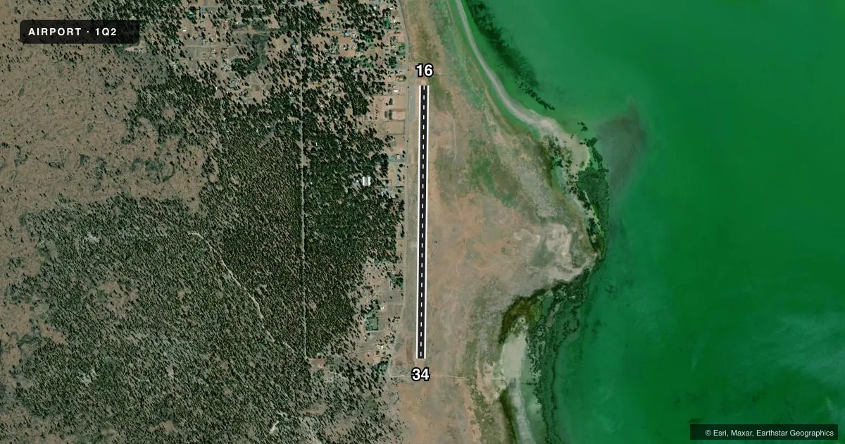
Full pagePattern entry · RWY 16
LEFT TRAFFICAirport sketch
Runways drawn to scale from FAA survey coordinates, rendered over satellite imagery. Not for navigation.
Approaches & charts
Services on the field
Fuel grades, oxygen, maintenance, ramp storage and lighting — as declared to the FAA by the airport operator.
Fuel & services
- Fuel
- Not available
- Oxygen (bottled)
- Not available
- Oxygen (bulk)
- Not available
- Airframe repair
- Not available
- Power plant repair
- Not available
Ramp & ground
- Transient storage
- Tie-down
- Landing fee
- No fee published
- Customs
- Not available
- Lighting schedule
- SEE RMK
- Beacon schedule
- SS-SR
- Beacon
- White / Green (civil land)(WG)
- Wind indicator
- Yes
- Segmented circle
- Yes
Fuel & FBOs
Cheapest 100LL and Jet A on the field and nearby. Always confirm with the FBO before taxi.
Airport notes
Surface conditions, obstructions, local procedures, lighting outages and other notes published with each FAA cycle.
General notes
- FOR CD CTC OAKLAND ARTCC AT 510-745-3380.
Lighting notes
- ACTVT MIRL RY 16/34 FREQ - 122.8.
Other notes
- THIS AIRPORT HAS BEEN SURVEYED BY THE NATIONAL GEODETIC SURVEY.
- MANAGERLASSEN CO DIR OF PUB WORKS.
- MANAGERLASSEN COUNTY PUBLIC WORKS OFFICE SUSANVILLE.
VFR map & nearby airports
VFR sectional. Tap any ICAO chip to open that airport.
Key facts · 1Q2
Answer card- ICAO
- 1Q2
- Name
- SPAULDING
- Location
- SUSANVILLE, CALIFORNIA
- Elevation
- 5,115.8 ft MSL
- Traffic pattern altitude
- 5,915.8 ft MSL (800 AGL)
- Control tower
- Non-towered (use CTAF)
- Total runways
- 1
- Longest runway
- 16/34 · 4,600 ft
- Published ILS approaches
- 0
- Published frequencies
- 1
- Magnetic variation
- 17°
- Current flight rules
- VFR
- Current wind
- 000° at 0 kt
- Favored runway now
- –
Spaulding Airport sits in Susanville, California. The field elevation is 5,115.8 ft MSL. It has one runway. Runway 16/34 is 4,600 ft long with an asphalt surface. The airport is not towered. CTAF is 122.9. The published pattern altitude is 800 ft AGL, which is 5,915.8 ft MSL.
No ILS approaches are published here. That makes current weather and local terrain more important on arrival and departure. The airport sits in high country, so performance planning matters. Expect density altitude to be a real factor in warm weather. The published remarks also note medium intensity runway lights on 16/34. They are activated by frequency 122.8. For clearance delivery, contact Oakland ARTCC at 510-745-3380. The airport manager is the Lassen County Director of Public Works. There are no on-field FBOs listed, so plan to verify services directly with the airport operator before you go.