METAR & TAF O55
O55 does not publish a METAR.
Showing the nearest reporting station: KAAT (ALTURAS MUNI) · 32.6 NM away. Conditions at O55 may differ.
METAR · KAAT
Observed 11:55Z
KAAT 271155Z AUTO 00000KT 10SM CLR 07/M01 A3017 RMK AO2 SLP178 T00721011 10183 20072 53004 $
- Wind
- 000° @ 0 kt
- Visibility
- 10 SM
- Temp / Dew
- 7°C / -1°C
- Altimeter
- 30.17 inHg
- Clouds
- CLR
- Density alt
- 3,892 ft
- Ceiling
- Unlimited
- Rules
- VFR
Airport info & contacts
Manager on record, flight service, ARTCC, attendance schedule and pattern altitude — published by the FAA and refreshed every 28 days.
Location
- From city
- 2 NM NE
- VFR sectional
- KLAMATH FALLS
- ARTCC
- ZSE · SEATTLE
- NOTAM facility
- RIU (NOTAM-D)
Airport manager
- Name
- KAYLA NEELY
- Phone
- 530-251-8289
- Address
- 707 NEVADA ST, SUSANVILLE CA 96130
Flight service · Hours
- FSS RIU
- RANCHO MURIETA1-800-WX-BRIEF
- Attendance
- Unattended
Frequencies
Tap any row to copy the frequency to your clipboard.
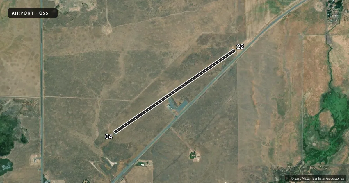
Runways & pattern
Full pagePattern entry · RWY 04
LEFT TRAFFICRunway end performance
| End | TORA | TODA | ASDA | LDA | VGSI | Approach lights | Obstruction |
|---|---|---|---|---|---|---|---|
| 04 | — | — | — | — | — | — | 65', trees, 1600' from thr, 100' R of cntrln, slope 21 |
| 22 | — | — | — | — | — | — | 15', road, 200' from thr, 100' R of cntrln, slope 0 |
Declared distances in feet. TORA = takeoff run available, TODA = takeoff distance, ASDA = accelerate-stop, LDA = landing distance.
Airport sketch
Runways drawn to scale from FAA survey coordinates, rendered over satellite imagery. Not for navigation.
Approaches & charts
Services on the field
Fuel grades, oxygen, maintenance, ramp storage and lighting — as declared to the FAA by the airport operator.
Fuel & services
- Fuel
- Not available
- Oxygen (bottled)
- Not available
- Oxygen (bulk)
- Not available
- Airframe repair
- Not available
- Power plant repair
- Not available
Ramp & ground
- Transient storage
- Tie-down
- Landing fee
- No fee published
- Customs
- Not available
- Lighting schedule
- SEE RMK
- Beacon schedule
- SS-SR
- Beacon
- White / Green (civil land)(WG)
- Wind indicator
- Lighted
- Segmented circle
- Yes
Fuel & FBOs
Cheapest 100LL and Jet A on the field and nearby. Always confirm with the FBO before taxi.
Airport notes
Surface conditions, obstructions, local procedures, lighting outages and other notes published with each FAA cycle.
General notes
- FOR CD CTC SEATTLE ARTCC AT 253-351-3694.
Lighting notes
- ACTVT LIRL RWY 04/22 - CTAF.
Approach & departure obstructions
- 22+3' FENCE 0-60' DIAGONALLY ACROSS PRIMARY SURFACE.
- 22APCH RATIO 20:1 TO DSPLCD THLD.
Other notes
- PREDATES TO 1958 FA ACT.
- MANAGERLASSEN COUNTY DEPUTY DIRECTOR OF PUBLIC WORKS.
- MANAGERPUBLIC WORKS DEPARTMENT, SUSANVILLE.
VFR map & nearby airports
VFR sectional. Tap any ICAO chip to open that airport.
Key facts · O55
Answer card- ICAO
- O55
- Name
- SOUTHARD FLD
- Location
- BIEBER, CALIFORNIA
- Elevation
- 4,163 ft MSL
- Traffic pattern altitude
- 5,163 ft MSL (1,000 AGL)
- Control tower
- Non-towered (use CTAF)
- Total runways
- 1
- Longest runway
- 04/22 · 2,980 ft
- Published ILS approaches
- 0
- Published frequencies
- 1
- Magnetic variation
- 17°
- Current flight rules
- VFR
- Current wind
- 000° at 0 kt
- Favored runway now
- –
Southard Fld sits near Bieber, California. The field elevation is 4,163 ft MSL. It has one runway. Runway 04/22 is 2,980 ft of asphalt, so plan performance with the elevation in mind. This is an untowered field. CTAF is 122.9. No ILS approaches are published here.
The pattern altitude is not published. Use the standard 1,000 ft AGL pattern unless the current FAA Chart Supplement says otherwise. That puts the light piston pattern at 5,163 ft MSL based on the listed field elevation. The airport is a good example of a high-desert strip where density altitude can matter on warm days. Check your takeoff and landing numbers before you go.
Published remarks note low intensity runway lights on 04/22 that are activated through the CTAF. They also note an obstruction issue near runway 22. The approach slope to the displaced threshold on 22 is 20 to 1. A 3-foot fence is reported 0 to 60 feet diagonally across the primary surface at runway 22. There are no on-field FBOs listed here. Check with the airport operator or the FBO directly by phone for current services before arrival. For clearance delivery, contact Seattle ARTCC at 253-351-3694.