METAR & TAF KAAT
Current METAR
Observed 11:55Z
KAAT 271155Z AUTO 00000KT 10SM CLR 07/M01 A3017 RMK AO2 SLP178 T00721011 10183 20072 53004 $
- Wind
- 000° @ 0 kt
- Visibility
- 10 SM
- Temp / Dew
- 7°C / -1°C
- Altimeter
- 30.17 inHg
- Clouds
- CLR
- Density alt
- 4,159 ft
- Ceiling
- Unlimited
- Rules
- VFR
Airport info & contacts
Manager on record, flight service, ARTCC, attendance schedule and pattern altitude — published by the FAA and refreshed every 28 days.
Location
- From city
- 1 NM W
- VFR sectional
- KLAMATH FALLS
- ARTCC
- ZSE · SEATTLE
- NOTAM facility
- AAT (NOTAM-D)
Airport manager
- Name
- WARREN FARNAM
- Phone
- 530-233-2377
- Address
- 200 NORTH STREET, ALTURAS CA 96101
Flight service · Hours
- FSS RNO
- RENO1-800-WX-BRIEF
- Attendance
- 0800-1700
Frequencies
Tap any row to copy the frequency to your clipboard.
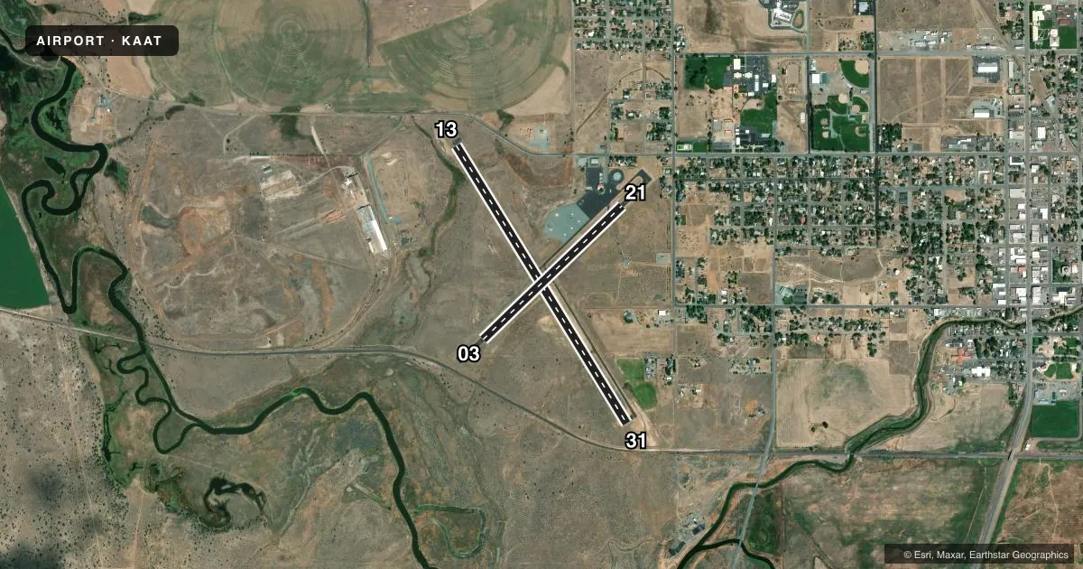
Runways & pattern
Full pagePattern entry · RWY 13
RIGHT TRAFFIC| Runway | Heading (°M) | Length | Surface | Traffic |
|---|---|---|---|---|
| 13/31 | 132° / 312° | 4,228 ft | ASPH | 13 R |
| 03/21 | 30° / 210° | 2,506 ft | ASPH | 21 R |
Runway end performance
| End | TORA | TODA | ASDA | LDA | VGSI | Approach lights | Obstruction |
|---|---|---|---|---|---|---|---|
| 13 | — | — | — | — | — | — | 16', road, 300' from thr, 150' R of cntrln, slope 6 |
| 31 | — | — | — | — | — | — | 15', rr, 250' from thr, 250' R of cntrln, slope 3 |
| 03 | — | — | — | — | VASI 2-box left(3°) | — | 23', rr, 275' from thr, 0' R of cntrln, slope 3 |
| 21 | — | — | — | — | — | — | 20', tree, 380' from thr, 0' R of cntrln, slope 9 |
Declared distances in feet. TORA = takeoff run available, TODA = takeoff distance, ASDA = accelerate-stop, LDA = landing distance.
Airport sketch
Runways drawn to scale from FAA survey coordinates, rendered over satellite imagery. Not for navigation.
Approaches & charts
Services on the field
Fuel grades, oxygen, maintenance, ramp storage and lighting — as declared to the FAA by the airport operator.
Fuel & services
- Fuel
- 100LLA
- Airframe repair
- Not available
- Power plant repair
- Not available
- Other services
- AMB,CHTR,INSTR
Ramp & ground
- Transient storage
- Tie-down
- Landing fee
- No fee published
- Lighting schedule
- SEE RMK
- Beacon schedule
- SS-SR
- Beacon
- White / Green (civil land)(WG)
- Wind indicator
- Lighted
- Segmented circle
- Yes
Fuel & FBOs
Cheapest 100LL and Jet A on the field and nearby. Always confirm with the FBO before taxi.
Airport notes
Surface conditions, obstructions, local procedures, lighting outages and other notes published with each FAA cycle.
General notes
- NO TKOF RY 03 TO NE EXCP DURG ADVERSE WIND COND. 150 FT MIN ALT OVER HOUSES.
- WILDLIFE REFUGES TO THE SW; SOUTH AND SE PRESENT POTENTIAL BIRD HAZARDS TO ACFT FROM OCT THRU APR.
- FIRE FIGHTTING ACFT SEASONAL MAY-OCT.
- ARRIVALS RY 21 DISCOURAGED DUE TO SCHOOL ON APCH.
- DEER ON AND IN THE VICINITY OF ARPT.
- FOR CD CTC SEATTLE ARTCC AT 253-351-3694.
Lighting notes
- ACTVT REIL RWY 03 & 31; VASI RWY 03; MIRL RWY 13/31; LIRL RWY 03/21 - CTAF.
Runway surface & condition
- 03/21GROSS PAVEMENT STRENGTH PROVIDED BY AIRPORT MANAGER.
Approach & departure obstructions
- 03RWY 03 APCH RATIO 22:1 FM DSPLCD THLD.
- 13RY 13 APCH RATIO 28:1 FM DSPLCD THR.
- 21RW 21 APCH RATIO 35:1 FM DSPLCD THLD.
Other notes
- ESTABD PRIOR TO 15 MAY 1959.
- MANAGERDIR. OF PUBLIC WORKS (530) 233-2377.
- OWNEROPERD BY CITY OF ALTURAS.
- MANAGERPUBLIC WORKS IN ALTURAS. FBO AT ARPT 530-233-5125 OR 530-708-1852.
VFR map & nearby airports
VFR sectional. Tap any ICAO chip to open that airport.
Key facts · KAAT
Answer card- ICAO
- KAAT
- Name
- ALTURAS MUNI
- Location
- ALTURAS, CALIFORNIA
- Elevation
- 4,378.3 ft MSL
- Traffic pattern altitude
- 5,378.3 ft MSL (1,000 AGL)
- Control tower
- Non-towered (use CTAF)
- Total runways
- 2
- Longest runway
- 13/31 · 4,228 ft
- Published ILS approaches
- 0
- Published frequencies
- 2
- Magnetic variation
- 16°
- Current flight rules
- VFR
- Current wind
- 000° at 0 kt
- Favored runway now
- –
Alturas Muni sits in Alturas, California. The field elevation is 4,378.3 ft MSL. It has two asphalt runways. The longest is 4,228 ft on runway 13/31. There is no control tower. CTAF and UNICOM are both 122.8.
No ILS approaches are published here. Pattern altitude is not published, so use the standard 1,000 ft AGL for light piston traffic unless current local guidance says otherwise. That puts the pattern around 5,378 ft MSL based on the field elevation. The airport is operated by the City of Alturas. Alturas Municipal Airport is on the field. It carries AVGAS 100LL and JET A. Call the FBO directly at (530) 233-5125 for current service details.
This is a high-elevation airport, so performance planning matters. Deer are reported on and near the airport. Wildlife refuges to the southwest, south and southeast can mean bird activity from October through April. Runway 03 has a published note against takeoff to the northeast except in adverse wind conditions. Arrivals to runway 21 are discouraged because of a school on the approach. Runway 13 and runway 21 also have published approach clearance notes from displaced thresholds. Check the current Chart Supplement before you go.