METAR & TAF O59
O59 does not publish a METAR.
Showing the nearest reporting station: KAAT (ALTURAS MUNI) · 18.5 NM away. Conditions at O59 may differ.
METAR · KAAT
Observed 12:55Z
KAAT 271255Z AUTO 00000KT 10SM CLR 06/M02 A3017 RMK AO2 SLP180 T00611017 $
- Wind
- 000° @ 0 kt
- Visibility
- 10 SM
- Temp / Dew
- 6°C / -2°C
- Altimeter
- 30.17 inHg
- Clouds
- CLR
- Density alt
- 4,343 ft
- Ceiling
- Unlimited
- Rules
- VFR
Airport info & contacts
Manager on record, flight service, ARTCC, attendance schedule and pattern altitude — published by the FAA and refreshed every 28 days.
Location
- From city
- 2 NM N
- VFR sectional
- KLAMATH FALLS
- ARTCC
- ZSE · SEATTLE
- NOTAM facility
- RNO (NOTAM-D)
Airport manager
- Name
- MITCH CROSBY
- Phone
- 530-233-6412
- Address
- 202 W 4TH ST, ALTURAS CA 96101
Flight service · Hours
- FSS RNO
- RENO1-800-WX-BRIEF
Frequencies
Tap any row to copy the frequency to your clipboard.
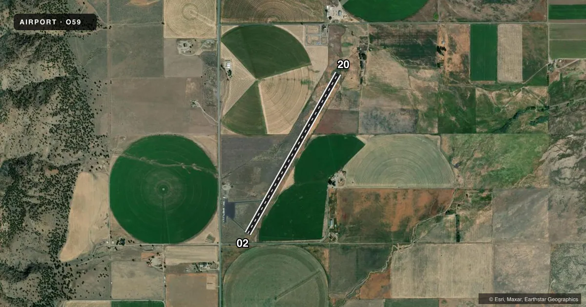
Runways & pattern
Full pagePattern entry · RWY 02
LEFT TRAFFICRunway end performance
| End | TORA | TODA | ASDA | LDA | VGSI | Approach lights | Obstruction |
|---|---|---|---|---|---|---|---|
| 02 | — | — | — | — | — | — | 15', road, 250' from thr, 130' R of cntrln, slope 3 |
Declared distances in feet. TORA = takeoff run available, TODA = takeoff distance, ASDA = accelerate-stop, LDA = landing distance.
Airport sketch
Runways drawn to scale from FAA survey coordinates, rendered over satellite imagery. Not for navigation.
Approaches & charts
Services on the field
Fuel grades, oxygen, maintenance, ramp storage and lighting — as declared to the FAA by the airport operator.
Fuel & services
- Fuel
- Not available
- Oxygen (bottled)
- Not available
- Oxygen (bulk)
- Not available
- Airframe repair
- Not available
Ramp & ground
- Transient storage
- Tie-down
- Landing fee
- No fee published
- Customs
- Not available
- Lighting schedule
- SEE RMK
- Beacon schedule
- SS-SR
- Beacon
- White / Green (civil land)(WG)
- Wind indicator
- Lighted
- Segmented circle
- No
Fuel & FBOs
Cheapest 100LL and Jet A on the field and nearby. Always confirm with the FBO before taxi.
Airport notes
Surface conditions, obstructions, local procedures, lighting outages and other notes published with each FAA cycle.
General notes
- FOR CD CTC SEATTLE ARTCC AT 253-351-3694.
Lighting notes
- ACTVT MIRL RY 02/20 - CTAF.
Approach & departure obstructions
- 02RWY 02 APCH RATIO 24:1 TO DSPLCD THR.
Other notes
- MANAGERROAD DEPARTMENT. NO FBO ON AIRPORT.
- MANAGERROAD DEPARTMENT, ALTURAS.
VFR map & nearby airports
VFR sectional. Tap any ICAO chip to open that airport.
Key facts · O59
Answer card- ICAO
- O59
- Name
- CEDARVILLE
- Location
- CEDARVILLE, CALIFORNIA
- Elevation
- 4,623 ft MSL
- Traffic pattern altitude
- 5,623 ft MSL (1,000 AGL)
- Control tower
- Non-towered (use CTAF)
- Total runways
- 1
- Longest runway
- 02/20 · 4,415 ft
- Published ILS approaches
- 0
- Published frequencies
- 2
- Magnetic variation
- 17°
- Current flight rules
- VFR
- Current wind
- 000° at 0 kt
- Favored runway now
- –
Cedarville Airport (O59) sits in Cedarville, California. The field elevation is 4,623 ft MSL. It has one runway. Runway 02/20 is 4,415 ft asphalt, which is the longest runway on the field. This is an uncontrolled airport with no tower. CTAF and UNICOM are both 122.8.
No ILS approaches are published here. Pattern altitude is not published in the facts, so use the current Chart Supplement and standard local practice before you go. The airport remarks also note that runway 02 has a clearance slope ratio of 24 to 1 to the displaced threshold. That matters if you are coming in low from the north. Medium intensity runway lights on 02/20 are activated by using the common traffic advisory frequency.
There is no fixed base operator on the airport. The manager is the Road Department in Alturas. For clearance delivery, the published remark directs pilots to Seattle ARTCC at 253-351-3694. With the elevation above 4,600 ft MSL, plan for performance and density altitude carefully. This is a high-elevation strip with one runway and no published ILS, so a current briefing and a conservative approach speed plan make sense before arrival.