METAR & TAF O81
O81 does not publish a METAR.
Showing the nearest reporting station: KLMT (CRATER LAKE/KLAMATH RGNL) · 23.0 NM away. Conditions at O81 may differ.
METAR · KLMT
Observed 11:53Z
KLMT 271153Z AUTO 00000KT 10SM CLR 09/06 A3014 RMK AO2 SLP166 T00890061 10167 20078 55000
- Wind
- 000° @ 0 kt
- Visibility
- 10 SM
- Temp / Dew
- 9°C / 6°C
- Altimeter
- 30.14 inHg
- Clouds
- CLR
- Density alt
- 4,028 ft
- Ceiling
- Unlimited
- Rules
- VFR
Airport info & contacts
Manager on record, flight service, ARTCC, attendance schedule and pattern altitude — published by the FAA and refreshed every 28 days.
Location
- From city
- 7 NM SE
- VFR sectional
- KLAMATH FALLS
- Pattern altitude
- 800 ft AGL · 4,849 ft MSL
- ARTCC
- ZSE · SEATTLE
- NOTAM facility
- RIU (NOTAM-D)
Airport manager
- Name
- MITCH CROSBY
- Phone
- (530) 233-6412
- Address
- 202 W 4TH ST, ALTURAS CA 96101
Flight service · Hours
- FSS RIU
- RANCHO MURIETA1-800-WX-BRIEF
- Attendance
- JUN-AUG · 0600-1700
- SEP-MAY · MON-FRI · 0800-1700
- SEP-MAY · SAT-SUN · ON CALL
Frequencies
Tap any row to copy the frequency to your clipboard.
Runways & pattern
Full pagePattern entry · RWY 12
LEFT TRAFFICRunway end performance
| End | TORA | TODA | ASDA | LDA | VGSI | Approach lights | Obstruction |
|---|---|---|---|---|---|---|---|
| 12 | — | — | — | — | — | — | 15', road, 650' from thr, 170' R of cntrln, slope 30 |
Declared distances in feet. TORA = takeoff run available, TODA = takeoff distance, ASDA = accelerate-stop, LDA = landing distance.
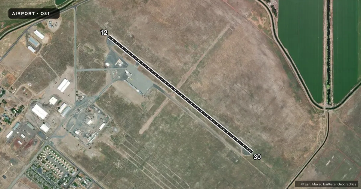
Airport sketch
Runways drawn to scale from FAA survey coordinates, rendered over satellite imagery. Not for navigation.
Approaches & charts
Services on the field
Fuel grades, oxygen, maintenance, ramp storage and lighting — as declared to the FAA by the airport operator.
Fuel & services
- Fuel
- 100LLA
- Oxygen (bottled)
- Not available
- Oxygen (bulk)
- Not available
- Airframe repair
- Minor
- Power plant repair
- Minor
- Other services
- AGRI
Ramp & ground
- Transient storage
- Tie-down
- Landing fee
- No fee published
- Customs
- Not available
- Lighting schedule
- SEE RMK
- Beacon schedule
- SS-SR
- Beacon
- White / Green (civil land)(WG)
- Wind indicator
- Lighted
- Segmented circle
- No
Fuel & FBOs
Cheapest 100LL and Jet A on the field and nearby. Always confirm with the FBO before taxi.
Airport notes
Surface conditions, obstructions, local procedures, lighting outages and other notes published with each FAA cycle.
General notes
- FOR CD CTC SEATTLE ARTCC AT 253-351-3694.
Lighting notes
- ACTVT MIRL RWY 12/30 - 122.8.
Fuel notes
- 100LLFOR FUEL CALL (530) 664-2661.
Other notes
- ESTBD PRIOR TO MAY 15 1959.
- MANAGERROADS COMMISSIONER. FBO AT ARPT 530-664-2661.
- OWNERLEASED TO AND MAINTAINED BY COUNTY OF MODOC.
- MANAGERROADS DEPT OFC ALTURAS.
VFR map & nearby airports
VFR sectional. Tap any ICAO chip to open that airport.
Key facts · O81
Answer card- ICAO
- O81
- Name
- TULELAKE MUNI
- Location
- TULELAKE, CALIFORNIA
- Elevation
- 4,048.7 ft MSL
- Traffic pattern altitude
- 4,848.7 ft MSL (800 AGL)
- Control tower
- Non-towered (use CTAF)
- Total runways
- 1
- Longest runway
- 12/30 · 3,577 ft
- Published ILS approaches
- 0
- Published frequencies
- 1
- Magnetic variation
- 17°
- Current flight rules
- VFR
- Current wind
- 000° at 0 kt
- Favored runway now
- –
Tulelake Muni sits in Tulelake, California. The field elevation is 4,048.7 ft MSL. It has one runway. Runway 12/30 is 3,577 ft long with asphalt pavement. The airport is non-towered. CTAF is 122.9.
Pattern altitude is 800 ft AGL. That puts the published pattern at 4,848.7 ft MSL. No ILS approaches are published here. The runway headings are magnetic 129° and 309°. Medium intensity runway lights on 12/30 are activated by radio on 122.8.
This is a high-elevation field, so performance planning matters. Expect thinner air than you get at lowland airports. Check density altitude before departure, especially on warm days. The airport is leased to and maintained by Modoc County. The roads commissioner is the airport manager. The roads department office in Alturas is the airport manager contact. For fuel, call 530-664-2661. The published remarks also say the airport has a fixed base operator on the field, but no on-field FBO name is listed in the facts. If you need current fuel or local field details, call ahead. For clearance delivery, contact Seattle ARTCC at 253-351-3694.