METAR & TAF A32
A32 does not publish a METAR.
Showing the nearest reporting station: KLMT (CRATER LAKE/KLAMATH RGNL) · 19.4 NM away. Conditions at A32 may differ.
METAR · KLMT
Observed 03:53Z
KLMT 270353Z AUTO 34011KT 10SM CLR 23/04 A3008 RMK AO2 SLP145 T02280039
- Wind
- 340° @ 11 kt
- Visibility
- 10 SM
- Temp / Dew
- 23°C / 4°C
- Altimeter
- 30.08 inHg
- Clouds
- CLR
- Density alt
- 6,023 ft
- Ceiling
- Unlimited
- Rules
- VFR
Airport info & contacts
Manager on record, flight service, ARTCC, attendance schedule and pattern altitude — published by the FAA and refreshed every 28 days.
Location
- From city
- 5 NM SW
- VFR sectional
- KLAMATH FALLS
- Pattern altitude
- 800 ft AGL · 5,043 ft MSL
- ARTCC
- ZSE · SEATTLE
- NOTAM facility
- RIU (NOTAM-D)
Airport manager
- Name
- ADAM FILIPPONE
- Phone
- 530-842-8259
- Address
- 190 GREENHORN ROAD, YREKA CA 96097
Flight service · Hours
- FSS RIU
- RANCHO MURIETA1-800-WX-BRIEF
- Attendance
- Unattended
Frequencies
Tap any row to copy the frequency to your clipboard.
Runways & pattern
Full pagePattern entry · RWY 34
LEFT TRAFFICRunway end performance
| End | TORA | TODA | ASDA | LDA | VGSI | Approach lights | Obstruction |
|---|---|---|---|---|---|---|---|
| 16 | — | — | — | — | — | — | 15', road, 520' from thr, 0' R of cntrln, slope 21 |
| 34 | — | — | — | — | — | — | 5', fence, 350' from thr, 0' R of cntrln, slope 28 |
Declared distances in feet. TORA = takeoff run available, TODA = takeoff distance, ASDA = accelerate-stop, LDA = landing distance.
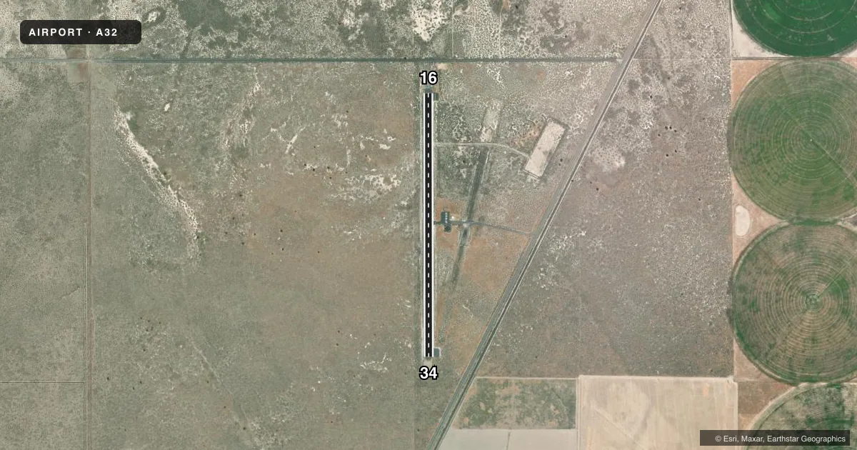
Airport sketch
Runways drawn to scale from FAA survey coordinates, rendered over satellite imagery. Not for navigation.
Approaches & charts
Services on the field
Fuel grades, oxygen, maintenance, ramp storage and lighting — as declared to the FAA by the airport operator.
Fuel & services
- Fuel
- Not available
- Oxygen (bottled)
- Not available
- Oxygen (bulk)
- Not available
- Airframe repair
- Not available
- Power plant repair
- Not available
Ramp & ground
- Transient storage
- Tie-down
- Landing fee
- No fee published
- Customs
- Not available
- Lighting schedule
- SEE RMK
- Beacon schedule
- SS-SR
- Beacon
- White / Green (civil land)(WG)
- Wind indicator
- Lighted
- Segmented circle
- Yes
Fuel & FBOs
Cheapest 100LL and Jet A on the field and nearby. Always confirm with the FBO before taxi.
Airport notes
Surface conditions, obstructions, local procedures, lighting outages and other notes published with each FAA cycle.
General notes
- (E81) TAXIWAY LIGHTS AT ENTRANCE TO TWYS ONLY.
- APRT RSTRD BY APRT OWNER TO ACFT WITH MAX CERT TKOF WT OF 12500 LBS OR LESS; CALL AMGR 530-842-8259 FOR MORE INFO.
- FOR CD CTC SEATTLE ARTCC AT 253-351-3694.
Lighting notes
- ACTVT MIRL RY 16/34 KEY 122.9; 5 TIMES.
Other notes
- MANAGEREMAIL: AFILIPPONE@CO.SISKIYOU.CA.US
- MANAGERAMGR OFC IN YREKA.
VFR map & nearby airports
VFR sectional. Tap any ICAO chip to open that airport.
Key facts · A32
Answer card- ICAO
- A32
- Name
- BUTTE VALLEY
- Location
- DORRIS, CALIFORNIA
- Elevation
- 4,243.1 ft MSL
- Traffic pattern altitude
- 5,043.1 ft MSL (800 AGL)
- Control tower
- Non-towered (use CTAF)
- Total runways
- 1
- Longest runway
- 16/34 · 4,300 ft
- Published ILS approaches
- 0
- Published frequencies
- 1
- Magnetic variation
- 18°
- Current flight rules
- VFR
- Current wind
- 340° at 11 kt
- Favored runway now
- RWY 34
Butte Valley Airport sits in Dorris, California. The field elevation is 4,243.1 ft MSL. It has one runway. Runway 16/34 is 4,300 ft long with asphalt pavement. The airport is not towered. CTAF is 122.9.
Pattern altitude is 800 ft AGL, which puts the traffic pattern at 5,043.1 ft MSL. No ILS approaches are published here, so plan with current charts and weather in mind before you go. The airport is restricted by the owner to aircraft with a maximum certified takeoff weight of 12,500 pounds or less. That matters if you are bringing a heavier airplane. Taxiway lights are only at the taxiway entrances. Runway lights on 16/34 are activated by keying 122.9 five times.
There are no on-field FBOs listed. Check with the airport manager before arrival if you need current services. The manager is based in Yreka. The published remarks also note clearance delivery through Seattle ARTCC. With the elevation here, expect high-density-altitude performance to matter on warm days. Review the current FAA Chart Supplement before departure for any updated operational notes or restrictions.