METAR & TAF KSIY
Current METAR
Observed 12:53Z
KSIY 271253Z AUTO 00000KT 10SM CLR 12/04 A3009 RMK AO2 SLP179 T01170044
- Wind
- 000° @ 0 kt
- Visibility
- 10 SM
- Temp / Dew
- 12°C / 4°C
- Altimeter
- 30.09 inHg
- Clouds
- CLR
- Density alt
- 2,717 ft
- Ceiling
- Unlimited
- Rules
- VFR
Airport info & contacts
Manager on record, flight service, ARTCC, attendance schedule and pattern altitude — published by the FAA and refreshed every 28 days.
Location
- From city
- 3 NM NE
- VFR sectional
- KLAMATH FALLS
- ARTCC
- ZSE · SEATTLE
- NOTAM facility
- SIY (NOTAM-D)
Airport manager
- Name
- ADAM FILIPPONE
- Phone
- 530-842-8259
- Address
- 190 GREENHORN ROAD, YREKA CA 96097
Flight service · Hours
- FSS RIU
- RANCHO MURIETA1-800-WX-BRIEF
- Attendance
- 0800-1700
Frequencies
Tap any row to copy the frequency to your clipboard.
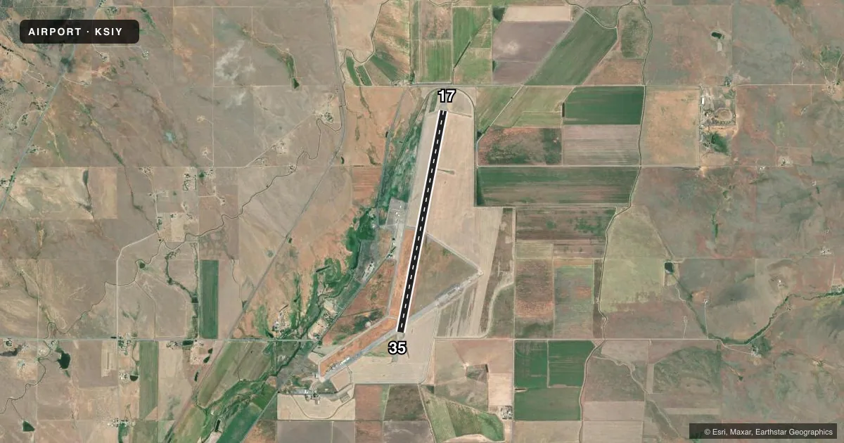
Runways & pattern
Full pagePattern entry · RWY 17
LEFT TRAFFICRunway end performance
| End | TORA | TODA | ASDA | LDA | VGSI | Approach lights | Obstruction |
|---|---|---|---|---|---|---|---|
| 17 | — | — | — | — | PAPI 2-box left(3°) | — | 15', road, 850' from thr, 0' R of cntrln, slope 43 |
| 35 | — | — | — | — | PAPI 2-box left(3°) | — | — |
Declared distances in feet. TORA = takeoff run available, TODA = takeoff distance, ASDA = accelerate-stop, LDA = landing distance.
Airport sketch
Runways drawn to scale from FAA survey coordinates, rendered over satellite imagery. Not for navigation.
Approaches & charts
Services on the field
Fuel grades, oxygen, maintenance, ramp storage and lighting — as declared to the FAA by the airport operator.
Fuel & services
- Fuel
- A
- Oxygen (bottled)
- Not available
- Oxygen (bulk)
- Not available
- Airframe repair
- Not available
- Power plant repair
- Not available
- Other services
- AGRI,CHTR
Ramp & ground
- Transient storage
- Tie-down
- Landing fee
- Yes
- Customs
- Not available
- Lighting schedule
- SEE RMK
- Beacon schedule
- SS-SR
- Beacon
- White / Green (civil land)(WG)
- Wind indicator
- Lighted
- Segmented circle
- Yes
Fuel & FBOs
Cheapest 100LL and Jet A on the field and nearby. Always confirm with the FBO before taxi.
Airport notes
Surface conditions, obstructions, local procedures, lighting outages and other notes published with each FAA cycle.
General notes
- MIGRATORY FLOCKS OF WATERFOWL IN THE VICINITY OF ARPT DURING SPRING & FALL.
- USFS FIRE OPS MAY-SEP.
- BE ALERT FOR GLIDER OPS MAY-SEP.
- SENSITIVE AG CROPS ADJACENT TO RWY/TWY. ROTOCRAFT SHOULD AVOID OPERATING IN THESE AREAS.
- WILDLIFE IN THE VICINITY OF ARPT.
- FARMING ACTIVITIES AND EQUIPMENT INVOF RWYS AND TWYS.
- FOR CD CTC SEATTLE ARTCC AT 253-351-3694.
Lighting notes
- ACTVT MIRL RY 17/35, PAPI RYS 17 AND 35, REIL RYS 17 AND 35 - CTAF.
Other notes
- MANAGEREMAIL: AFILIPPONE@CO.SISKIYOU.CA.US
- MANAGERCOUNTY ARPT OFC - YREKA, 530-842-8297.
VFR map & nearby airports
VFR sectional. Tap any ICAO chip to open that airport.
Key facts · KSIY
Answer card- ICAO
- KSIY
- Name
- SISKIYOU COUNTY
- Location
- MONTAGUE, CALIFORNIA
- Elevation
- 2,651.1 ft MSL
- Traffic pattern altitude
- 3,651.1 ft MSL (1,000 AGL)
- Control tower
- Non-towered (use CTAF)
- Total runways
- 1
- Longest runway
- 17/35 · 7,490 ft
- Published ILS approaches
- 0
- Published frequencies
- 2
- Magnetic variation
- 19°
- Current flight rules
- VFR
- Current wind
- 000° at 0 kt
- Favored runway now
- –
Siskiyou County Airport is in Montague, California. The field elevation is 2,651.1 ft MSL. It has one runway, 17/35, which is 7,490 ft long with asphalt pavement. There is no control tower. CTAF and UNICOM are both 123.0. No ILS approaches are published here.
Pattern altitude is not published. Use the standard 1,000 ft AGL pattern for light piston aircraft unless the current Chart Supplement or local procedures say otherwise. Váli Aviation is on the field. It carries JET_A. Call (530) 459-3392 for current fuel and service details.
This is a field where wildlife matters. The Chart Supplement notes wildlife in the area, including migratory waterfowl in spring and fall. Farming activity is also close to the runways and taxiways. Glider operations are a factor from May through September. United States Forest Service fire operations also occur during that same period. The runway has medium intensity lights, PAPI on both ends and REIL on both ends. For clearance delivery, contact Seattle ARTCC at 253-351-3694. First-time pilots should plan for the elevation. They should also watch for mixed traffic and verify current procedures before arrival.