METAR & TAF A30
A30 does not publish a METAR.
Showing the nearest reporting station: KSIY (SISKIYOU COUNTY) · 21.9 NM away. Conditions at A30 may differ.
METAR · KSIY
Observed 12:53Z
KSIY 271253Z AUTO 00000KT 10SM CLR 12/04 A3009 RMK AO2 SLP179 T01170044
- Wind
- 000° @ 0 kt
- Visibility
- 10 SM
- Temp / Dew
- 12°C / 4°C
- Altimeter
- 30.09 inHg
- Clouds
- CLR
- Density alt
- 2,812 ft
- Ceiling
- Unlimited
- Rules
- VFR
Airport info & contacts
Manager on record, flight service, ARTCC, attendance schedule and pattern altitude — published by the FAA and refreshed every 28 days.
Location
- From city
- 3 NM S
- VFR sectional
- KLAMATH FALLS
- Pattern altitude
- 800 ft AGL · 3,528 ft MSL
- ARTCC
- ZSE · SEATTLE
- NOTAM facility
- RIU (NOTAM-D)
Airport manager
- Name
- ADAM FILIPPONE
- Phone
- 530-842-8259
- Address
- 190 GREENHORN ROAD, YREKA CA 96097
Flight service · Hours
- FSS RIU
- RANCHO MURIETA1-800-WX-BRIEF
- Attendance
- Unattended
Frequencies
Tap any row to copy the frequency to your clipboard.
Runways & pattern
Full pagePattern entry · RWY 16
RIGHT TRAFFICRunway end performance
| End | TORA | TODA | ASDA | LDA | VGSI | Approach lights | Obstruction |
|---|---|---|---|---|---|---|---|
| 16 | — | — | — | — | — | — | 25', tree, 710' from thr, 160' R of cntrln, slope 20 |
Declared distances in feet. TORA = takeoff run available, TODA = takeoff distance, ASDA = accelerate-stop, LDA = landing distance.
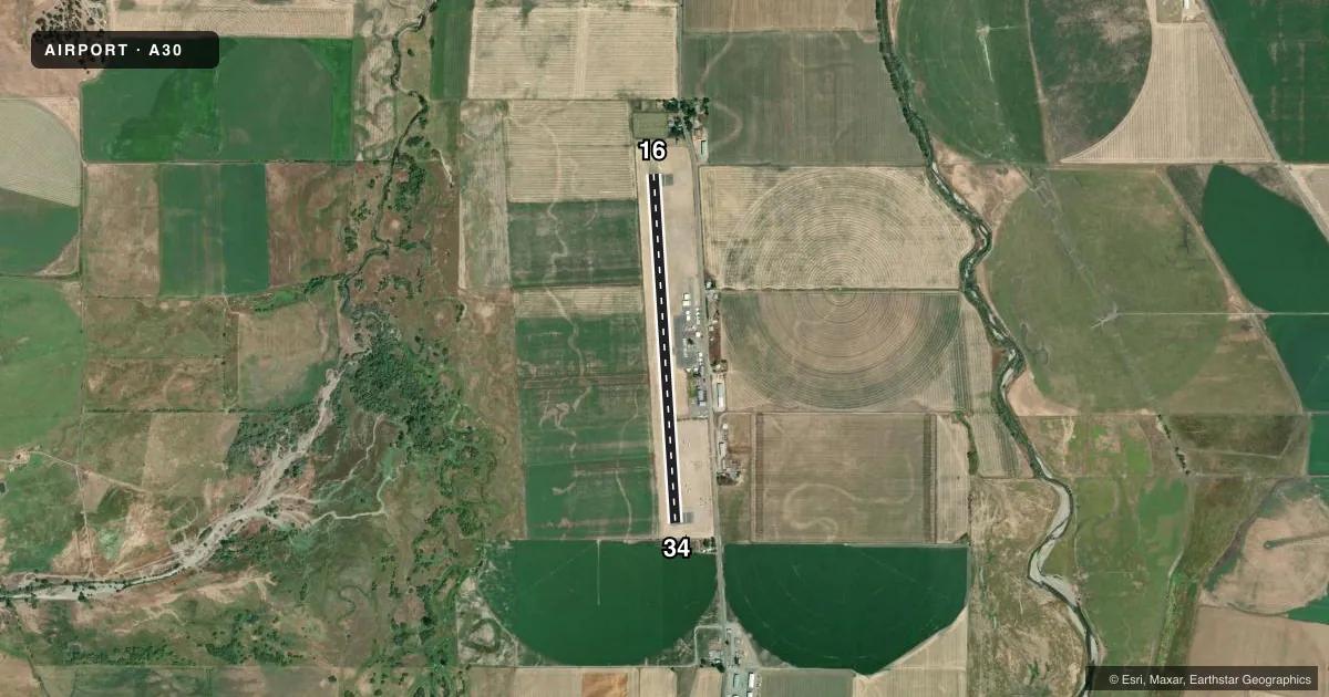
Airport sketch
Runways drawn to scale from FAA survey coordinates, rendered over satellite imagery. Not for navigation.
Approaches & charts
Services on the field
Fuel grades, oxygen, maintenance, ramp storage and lighting — as declared to the FAA by the airport operator.
Fuel & services
- Fuel
- 100LL
- Oxygen (bottled)
- Not available
- Oxygen (bulk)
- Not available
- Airframe repair
- Not available
- Power plant repair
- Not available
Ramp & ground
- Transient storage
- Tie-down
- Landing fee
- No fee published
- Customs
- Not available
- Lighting schedule
- SEE RMK
- Beacon schedule
- SS-SR
- Beacon
- White / Green (civil land)(WG)
- Wind indicator
- Lighted
- Segmented circle
- Yes
Fuel & FBOs
Cheapest 100LL and Jet A on the field and nearby. Always confirm with the FBO before taxi.
Airport notes
Surface conditions, obstructions, local procedures, lighting outages and other notes published with each FAA cycle.
General notes
- (E93) USFC HELIPORT. OPERATES FIRE SEASON ONLY.
- U.S. FOREST SVC FIRE ACTIVITY MAY THRU SEP.
- FOR CD CTC SEATTLE ARTCC AT 253-351-3694.
Lighting notes
- ACTVT MIRL RWY 16/34 - CTAF.
Approach & departure obstructions
- 34+4 FT FENCE 360 FT FM DISP THLD 160 FT FM EOR.
Other notes
- U.S. FOREST SVC HELICOPTER MAY THRU SEP.
- OPN NOT CONTINUOUS; LOCATED IN PILOT LOUNGE.
- MANAGERCOUNTY AIRPORT OFFICE - YREKA. ASTUMBAUGH@CO.SISKIYOU.CA.US.
- MANAGERCOUNTY DIR OF ARPTS OFFICE IN YREKA.
VFR map & nearby airports
VFR sectional. Tap any ICAO chip to open that airport.
Key facts · A30
Answer card- ICAO
- A30
- Name
- SCOTT VALLEY
- Location
- FORT JONES, CALIFORNIA
- Elevation
- 2,728 ft MSL
- Traffic pattern altitude
- 3,528 ft MSL (800 AGL)
- Control tower
- Non-towered (use CTAF)
- Total runways
- 1
- Longest runway
- 16/34 · 3,700 ft
- Published ILS approaches
- 0
- Published frequencies
- 2
- Magnetic variation
- 18°
- Current flight rules
- VFR
- Current wind
- 000° at 0 kt
- Favored runway now
- –
Scott Valley Airport (A30) is in Fort Jones, California. The field elevation is 2,728 ft MSL. It has one runway. Runway 16/34 is 3,700 ft long and asphalt. There is no control tower. CTAF and UNICOM are both 122.8. UNICOM is open but not continuous. It is located in the pilot lounge.
Pattern altitude is 800 ft AGL. That puts the pattern at 3,528 ft MSL. No ILS approaches are published here, so plan with the current chart and your own arrival setup in mind. The runway lights on 16/34 are medium intensity. They are activated by the CTAF.
Scott Valley Pilots Association is on the field. It carries 100LL. Call (530) 598-5211 for current fuel or ramp details. Published remarks also note U.S. Forest Service helicopter activity from May through September. Fire season activity can affect traffic flow. There is also a 4-foot fence near the runway 34 end, 160 feet from the end of runway 34. If you are unfamiliar with the field, review the current FAA Chart Supplement before arrival. Clearance delivery is handled through Seattle ARTCC at 253-351-3694.