METAR & TAF 36S
36S does not publish a METAR.
Showing the nearest reporting station: KCEC (JACK MC NAMARA FLD) · 38.0 NM away. Conditions at 36S may differ.
METAR · KCEC
Observed 05:56Z
KCEC 270556Z AUTO 00000KT 10SM CLR 14/13 A3013 RMK AO2 SLP202 T01390133 10178 20133 51006
- Wind
- 000° @ 0 kt
- Visibility
- 10 SM
- Temp / Dew
- 14°C / 13°C
- Altimeter
- 30.13 inHg
- Clouds
- CLR
- Density alt
- 1,119 ft
- Ceiling
- Unlimited
- Rules
- VFR
Airport info & contacts
Manager on record, flight service, ARTCC, attendance schedule and pattern altitude — published by the FAA and refreshed every 28 days.
Location
- From city
- 0 NM SW
- VFR sectional
- KLAMATH FALLS
- ARTCC
- ZSE · SEATTLE
- NOTAM facility
- RIU (NOTAM-D)
Airport manager
- Name
- JOY D HALL
- Phone
- 530-842-8259
- Address
- 190 GREENHORN ROAD, YREKA CA 96097
Flight service · Hours
- FSS RIU
- RANCHO MURIETA1-800-WX-BRIEF
- Attendance
- Unattended
Frequencies
Tap any row to copy the frequency to your clipboard.
Runways & pattern
Full pagePattern entry · RWY 04
RIGHT TRAFFICRunway end performance
| End | TORA | TODA | ASDA | LDA | VGSI | Approach lights | Obstruction |
|---|---|---|---|---|---|---|---|
| 04 | — | — | — | — | — | — | 25', tree, 500' from thr, 120' R of cntrln, slope 12 |
| 22 | — | — | — | — | — | — | 10', brush, 200' from thr, 125' R of cntrln, slope 0 |
Declared distances in feet. TORA = takeoff run available, TODA = takeoff distance, ASDA = accelerate-stop, LDA = landing distance.
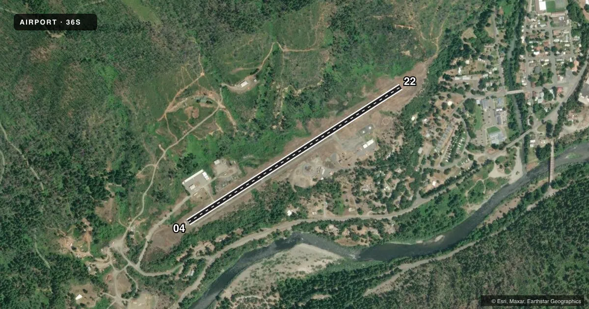
Airport sketch
Runways drawn to scale from FAA survey coordinates, rendered over satellite imagery. Not for navigation.
Approaches & charts
Services on the field
Fuel grades, oxygen, maintenance, ramp storage and lighting — as declared to the FAA by the airport operator.
Fuel & services
- Fuel
- Not available
- Oxygen (bottled)
- Not available
- Oxygen (bulk)
- Not available
- Airframe repair
- Not available
- Power plant repair
- Not available
Ramp & ground
- Transient storage
- Tie-down
- Landing fee
- No fee published
- Customs
- Not available
- Wind indicator
- Yes
- Segmented circle
- Yes
Fuel & FBOs
Cheapest 100LL and Jet A on the field and nearby. Always confirm with the FBO before taxi.
Airport notes
Surface conditions, obstructions, local procedures, lighting outages and other notes published with each FAA cycle.
General notes
- RWY 22 HAS +35' TREES 600' FROM THLD 125' EITHER SIDE OF CNTRLN.
- (E94) US FOREST SERVICE.
- FOR CD CTC SEATTLE ARTCC AT 253-351-3694.
Approach & departure obstructions
- 04RWY 04 HAS 3 FT FENCE O FEET FROM RWY END AND 80 FEET L.
- 22RY 22 HAS 8 FT SHRUB 0 FEET FM RY END AND 115 FT RIGHT.
- 04RY 04 APCH SLOPE 12:1 DUE TO 25 FT TREE 500 FT FM THLD.
- 22RY 22 APCH SLOPE 0:0 DUE TO 10 FT SHRUBS 200 FT FM THLD.
- 04RY 04 TREE AND SHRUB COVERED RISING TERRAIN.
- 22RY 22 TREE AND SHRUB COVERED RISING TERRAIN.
Other notes
- PUBLIC USE; VFR COND.
- US FOREST SVC MANS HELIPORT MAY THROUGH SEP.
- MANAGERDIRECTOR OF AIRPORTS OFFICE IN YREKA. ASTUMBAUGH@CO.SISKIYOU.CA.US.
- OWNEROPERD/MAINTD BY SISKIYOU COUNTY.
VFR map & nearby airports
VFR sectional. Tap any ICAO chip to open that airport.
Key facts · 36S
Answer card- ICAO
- 36S
- Name
- HAPPY CAMP
- Location
- HAPPY CAMP, CALIFORNIA
- Elevation
- 1,209 ft MSL
- Traffic pattern altitude
- 2,209 ft MSL (1,000 AGL)
- Control tower
- Non-towered (use CTAF)
- Total runways
- 1
- Longest runway
- 04/22 · 3,000 ft
- Published ILS approaches
- 0
- Published frequencies
- 1
- Magnetic variation
- 18°
- Current flight rules
- VFR
- Current wind
- 000° at 0 kt
- Favored runway now
- –
Happy Camp Airport is in Happy Camp, California. The field elevation is 1,209 ft MSL. It has one runway, 04/22, which is 3,000 ft long and asphalt. This is an uncontrolled airport with CTAF 122.9. No ILS approaches are published.
The pattern altitude is not published, so use the current Chart Supplement and local procedures before arrival. The airport is a public use field with VFR conditions noted in the remarks. The published notes also call out terrain and trees near both runway ends. Runway 04 has a steep approach path because of a tree on final. Runway 22 has rising terrain plus trees and shrubs near the threshold area. That makes a careful stabilized approach important, especially if you are new to the strip.
No on-field FBOs are listed. The remarks also say the U.S. Forest Service mans a heliport here from May through September. The airport is operated and maintained by Siskiyou County. For clearance delivery, the Chart Supplement lists Seattle ARTCC. If you need current airport details, check the current FAA Chart Supplement or contact the airport operator directly before you go.