METAR & TAF 3S4
3S4 does not publish a METAR.
Showing the nearest reporting station: KBOK (BROOKINGS) · 27.1 NM away. Conditions at 3S4 may differ.
METAR · KBOK
Observed 12:56Z
KBOK 271256Z AUTO 00000KT 10SM CLR 11/11 A3009 RMK AO2 SLP189 T01110106 PNO $
- Wind
- 000° @ 0 kt
- Visibility
- 10 SM
- Temp / Dew
- 11°C / 11°C
- Altimeter
- 30.09 inHg
- Clouds
- CLR
- Density alt
- 1,038 ft
- Ceiling
- Unlimited
- Rules
- VFR
Airport info & contacts
Manager on record, flight service, ARTCC, attendance schedule and pattern altitude — published by the FAA and refreshed every 28 days.
Location
- From city
- 4 NM SW
- VFR sectional
- KLAMATH FALLS
- ARTCC
- ZSE · SEATTLE
- NOTAM facility
- MMV (NOTAM-D)
Airport manager
- Name
- MICHAEL CRISAFULLI
- Phone
- 541-955-4535
- Address
- 1441 BROOKSIDE BLVD, GRANTS PASS OR 97526
Flight service · Hours
- FSS MMV
- MC MINNVILLE1-800-WX-BRIEF
- Attendance
- M-F · 0800-1700
Frequencies
Tap any row to copy the frequency to your clipboard.
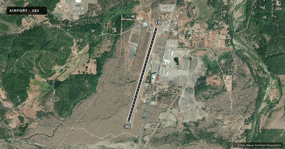
Runways & pattern
Full pagePattern entry · RWY 18
LEFT TRAFFICRunway end performance
| End | TORA | TODA | ASDA | LDA | VGSI | Approach lights | Obstruction |
|---|---|---|---|---|---|---|---|
| 18 | 4,807' | 4,807' | 4,807' | 4,682' | PAPI 2-box left(4°) | — | 15', road, 260' from thr, 170' R of cntrln, slope 4 |
| 36 | 4,682' | 4,682' | 4,807' | 4,682' | PAPI 2-box left(4°) | — | 54', trees, 928' from thr, 113' R of cntrln, slope 13 |
Declared distances in feet. TORA = takeoff run available, TODA = takeoff distance, ASDA = accelerate-stop, LDA = landing distance.
Airport sketch
Runways drawn to scale from FAA survey coordinates, rendered over satellite imagery. Not for navigation.
Approaches & charts
Services on the field
Fuel grades, oxygen, maintenance, ramp storage and lighting — as declared to the FAA by the airport operator.
Fuel & services
- Fuel
- Not available
- Oxygen (bottled)
- Not available
- Oxygen (bulk)
- Not available
- Airframe repair
- Not available
- Power plant repair
- Not available
- Other services
- INSTR
Ramp & ground
- Transient storage
- Tie-down
- Landing fee
- No fee published
- Customs
- Not available
- Lighting schedule
- SEE RMK
- Beacon schedule
- SS-SR
- Beacon
- White / Green (civil land)(WG)
- Wind indicator
- Lighted
- Segmented circle
- Yes
Fuel & FBOs
Cheapest 100LL and Jet A on the field and nearby. Always confirm with the FBO before taxi.
Airport notes
Surface conditions, obstructions, local procedures, lighting outages and other notes published with each FAA cycle.
General notes
- (E94) USFS WX STN.
- RY 36 DESIGNATED CALM WIND RY.
- FREQUENT ULTRA-LIGHT ACTIVITY.
- RWY HAS BASIC MARKINGS WITH SIDE STRIPES
- FOR CD CTC SEATTLE ARTCC AT 253-351-3694.
- 4 FT BRUSH IN PRI SFC AREA.
Lighting notes
- ACTVT REIL 18 & 36; MIRL RWY 18/36 - CTAF.
Runway surface & condition
- 18/36MIRL SET 1 FT OFF RWY EDGE
Approach & departure obstructions
- 18RWY 18 14:1 BASED ON DTHR. RWY 18 15 FT ROAD AT 330 FT ON CL 22:1 BASED ON DTHR
Other notes
- ESTABD PRIOR TO 1959.
- AUTOMATED UNICOM. ADZY ALSO AVBL BY CALLING 617-262-3825.
VFR map & nearby airports
VFR sectional. Tap any ICAO chip to open that airport.
Key facts · 3S4
Answer card- ICAO
- 3S4
- Name
- ILLINOIS VALLEY
- Location
- CAVE JUNCTION, OREGON
- Elevation
- 1,394 ft MSL
- Traffic pattern altitude
- 2,394 ft MSL (1,000 AGL)
- Control tower
- Non-towered (use CTAF)
- Total runways
- 1
- Longest runway
- 18/36 · 4,807 ft
- Published ILS approaches
- 0
- Published frequencies
- 1
- Magnetic variation
- 18°
- Current flight rules
- VFR
- Current wind
- 000° at 0 kt
- Favored runway now
- –
Illinois Valley Airport sits in Cave Junction, Oregon. Field elevation is 1,394 ft MSL. The airport has one runway. Runway 18/36 is 4,807 ft long with asphalt pavement. There is no control tower. CTAF is 122.9. No ILS approaches are published.
Pattern altitude is not published. Use 1,000 ft AGL for light piston traffic unless the current Chart Supplement says otherwise. Runway 36 is the calm wind runway. The field has medium intensity runway lights on 18/36. Runway end identifier lights are also installed. The runway markings are basic with side stripes.
No on-field FBOs are listed in the facts. Automated UNICOM is available. Advisory service is also available by phone. The published remarks also note frequent ultralight activity. There is a 4-foot brush condition in the primary surface area. Runway 18 has a displaced-threshold clearance note tied to a road near the centerline. That is worth a careful look on arrival. For clearance delivery, contact Seattle ARTCC. First-time visitors should plan for an uncontrolled field with mixed traffic. They should also plan for higher field elevation. There is no published ILS backup.