METAR & TAF KBOK
Current METAR
Observed 12:56Z
KBOK 271256Z AUTO 00000KT 10SM CLR 11/11 A3009 RMK AO2 SLP189 T01110106 PNO $
- Wind
- 000° @ 0 kt
- Visibility
- 10 SM
- Temp / Dew
- 11°C / 11°C
- Altimeter
- 30.09 inHg
- Clouds
- CLR
- Density alt
- -118 ft
- Ceiling
- Unlimited
- Rules
- VFR
Airport info & contacts
Manager on record, flight service, ARTCC, attendance schedule and pattern altitude — published by the FAA and refreshed every 28 days.
Location
- From city
- 1 NM NE
- VFR sectional
- KLAMATH FALLS
- ARTCC
- ZSE · SEATTLE
- NOTAM facility
- BOK (NOTAM-D)
Airport manager
- Name
- ANTHONY BARON
- Phone
- 541-661-4085
- Address
- 898 ELK DR, BROOKINGS OR 97415
Flight service · Hours
- FSS MMV
- MC MINNVILLE1-800-WX-BRIEF
- Attendance
- Unattended
Frequencies
Tap any row to copy the frequency to your clipboard.
Runways & pattern
Full pagePattern entry · RWY 12
RIGHT TRAFFICRunway end performance
| End | TORA | TODA | ASDA | LDA | VGSI | Approach lights | Obstruction |
|---|---|---|---|---|---|---|---|
| 12 | — | — | — | — | PAPI 2-box left(4°) | — | — |
| 30 | — | — | — | — | PAPI 2-box left(3°) | — | — |
Declared distances in feet. TORA = takeoff run available, TODA = takeoff distance, ASDA = accelerate-stop, LDA = landing distance.
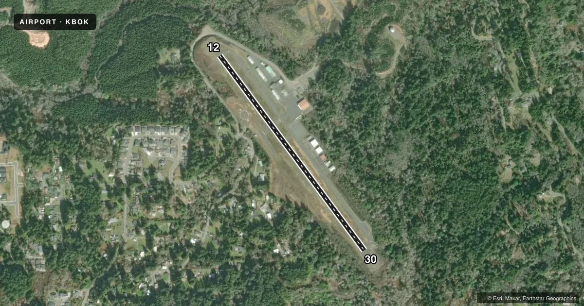
Airport sketch
Runways drawn to scale from FAA survey coordinates, rendered over satellite imagery. Not for navigation.
Approaches & charts
Services on the field
Fuel grades, oxygen, maintenance, ramp storage and lighting — as declared to the FAA by the airport operator.
Fuel & services
- Fuel
- 100LLA
- Oxygen (bottled)
- Not available
- Oxygen (bulk)
- Not available
- Airframe repair
- Not available
- Power plant repair
- Not available
- Other services
- INSTR,RNTL
Ramp & ground
- Transient storage
- Tie-down
- Landing fee
- No fee published
- Customs
- Not available
- Lighting schedule
- SEE RMK
- Beacon schedule
- SS-SR
- Beacon
- White / Green (civil land)(WG)
- Wind indicator
- Yes
- Segmented circle
- Yes
Fuel & FBOs
Cheapest 100LL and Jet A on the field and nearby. Always confirm with the FBO before taxi.
Airport notes
Surface conditions, obstructions, local procedures, lighting outages and other notes published with each FAA cycle.
General notes
- DEER AND ELK INVOF ARPT GROUNDS.
- FOR CD CTC SEATTLE ARTCC AT 253-351-3694.
Lighting notes
- ARB LIGHT BEAM OBSCURED BY TALLER TREES NE-SE QUADRANT.
- ACTVT MIRL RWY 12/30; PAPI RWY 12/30 - CTAF.
Other notes
- MANAGERALT CTC: JONATHAN TROST PHONE: 541-247-3232
VFR map & nearby airports
VFR sectional. Tap any ICAO chip to open that airport.
Key facts · KBOK
Answer card- ICAO
- KBOK
- Name
- BROOKINGS
- Location
- BROOKINGS, OREGON
- Elevation
- 461.9 ft MSL
- Traffic pattern altitude
- 1,461.9 ft MSL (1,000 AGL)
- Control tower
- Non-towered (use CTAF)
- Total runways
- 1
- Longest runway
- 12/30 · 2,901 ft
- Published ILS approaches
- 0
- Published frequencies
- 2
- Magnetic variation
- 14°
- Current flight rules
- VFR
- Current wind
- 000° at 0 kt
- Favored runway now
- –
Brookings Airport sits in Brookings, Oregon. Field elevation is 461.9 ft MSL. The airport has one runway. Runway 12/30 is 2,901 ft long and paved with asphalt. There is no control tower. CTAF and UNICOM are both 122.8. No ILS approaches are published here.
Pattern altitude is not published. Use 1,000 ft AGL as the standard light piston pattern unless the current Chart Supplement says otherwise. That puts the pattern at about 1,461.9 ft MSL based on the field elevation. Medium intensity runway lights are available on 12/30. The PAPI for 12/30 is controlled on CTAF.
Brookings Flying Club is on the field. It carries 100LL and Jet A. Call them at (541) 247-3253 before arrival if you need current service details. The Chart Supplement also notes that the rotating beacon can be hard to see from the northeast through southeast side because of taller trees. Deer and elk are also reported on the airport grounds, so keep a sharp scan on taxi and final. If you need clearance delivery, contact Seattle ARTCC at 253-351-3694.