METAR & TAF 0O9
0O9 does not publish a METAR.
Showing the nearest reporting station: KCEC (JACK MC NAMARA FLD) · 11.9 NM away. Conditions at 0O9 may differ.
METAR · KCEC
Observed 15:56Z
KCEC 271556Z AUTO 36004KT 10SM OVC014 16/12 A3011 RMK AO2 SLP196 T01560122
- Wind
- 360° @ 4 kt
- Visibility
- 10 SM
- Temp / Dew
- 16°C / 12°C
- Altimeter
- 30.11 inHg
- Clouds
- OVC
- Density alt
- 326 ft
- Ceiling
- 1,400 ft AGL
- Rules
- MVFR
Airport info & contacts
Manager on record, flight service, ARTCC, attendance schedule and pattern altitude — published by the FAA and refreshed every 28 days.
Location
- From city
- 1 NM W
- VFR sectional
- KLAMATH FALLS
- Pattern altitude
- 800 ft AGL · 1,156 ft MSL
- ARTCC
- ZSE · SEATTLE
- NOTAM facility
- OAK (NOTAM-D)
Airport manager
- Name
- SEAN ROSENTHAL
- Phone
- 707-464-7288
- Address
- 1650 DALE RUPERT ROAD, SUITE 100, CRESCENT CITY CA 95531
Flight service · Hours
- FSS OAK
- OAKLAND1-800-WX-BRIEF
- Attendance
- Unattended
Frequencies
Tap any row to copy the frequency to your clipboard.
Runways & pattern
Full pagePattern entry · RWY 06
LEFT TRAFFICRunway end performance
| End | TORA | TODA | ASDA | LDA | VGSI | Approach lights | Obstruction |
|---|---|---|---|---|---|---|---|
| 06 | — | — | — | — | — | — | 45', trees, 200' from thr, 85' R of cntrln, slope 1 |
| 24 | — | — | — | — | — | — | 50', trees, 235' from thr, 120' R of cntrln, slope 1 |
Declared distances in feet. TORA = takeoff run available, TODA = takeoff distance, ASDA = accelerate-stop, LDA = landing distance.
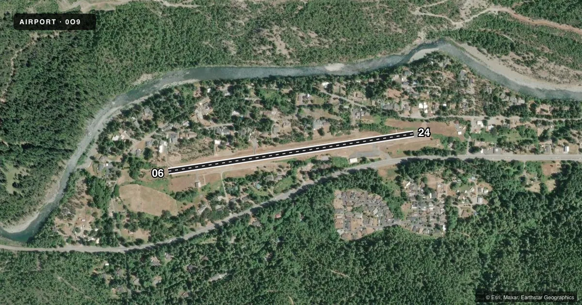
Airport sketch
Runways drawn to scale from FAA survey coordinates, rendered over satellite imagery. Not for navigation.
Approaches & charts
Services on the field
Fuel grades, oxygen, maintenance, ramp storage and lighting — as declared to the FAA by the airport operator.
Fuel & services
- Fuel
- Not available
Ramp & ground
- Transient storage
- Tie-down
- Landing fee
- No fee published
- Customs
- Not available
- Wind indicator
- Yes
- Segmented circle
- Yes
Fuel & FBOs
Cheapest 100LL and Jet A on the field and nearby. Always confirm with the FBO before taxi.
Airport notes
Surface conditions, obstructions, local procedures, lighting outages and other notes published with each FAA cycle.
General notes
- +5' BRUSH AND 30-100' TREES RIGHT AND LEFT IN PRIM SFC.
- ARPT IN CANYON; HIGH MOUNTAINS AND TREES SURROUND ARPT MOUNTAIN FLYING EXPERIENCE STRONGLY RECOMMENDED.
- NO NIGHT OPERATION AUTHORIZED.
- AP SFC CONDS NOT RPRTD.
- FOR CD CTC SEATTLE ARTCC AT 253-351-3694.
Approach & departure obstructions
- 063 FT FENCE AT 60 FT; 20 FT TREES AT 150 FT, 85 FT LEFT.
- 24+4' FENCE 0-200' LEFT & RIGHT.
- 06RWY 06 APCH SLOPE 14:1 DUE TO 35 FT TREE 500 FT FROM THE DSPLCD THLD.
- 24RWY 24 APCH SLOPE 9:1 DUE TO 100 FT TREE 950 FT FROM DSPLCD THLD.
Other notes
- ESTABD PRIOR TO 5/15/59.
- MANAGERAIRPORTS MANAGER LOCATED AT CEC.
VFR map & nearby airports
VFR sectional. Tap any ICAO chip to open that airport.
Key facts · 0O9
Answer card- ICAO
- 0O9
- Name
- WARD FLD
- Location
- GASQUET, CALIFORNIA
- Elevation
- 356 ft MSL
- Traffic pattern altitude
- 1,156 ft MSL (800 AGL)
- Control tower
- Non-towered (use CTAF)
- Total runways
- 1
- Longest runway
- 06/24 · 2,990 ft
- Published ILS approaches
- 0
- Published frequencies
- 1
- Magnetic variation
- 18°
- Current flight rules
- MVFR
- Current wind
- 360° at 4 kt
- Favored runway now
- RWY 06
WARD FLD sits in Gasquet, California. The field elevation is 356 ft MSL. It has one runway, 06/24, which is 2,990 ft long and paved. There is no control tower. CTAF is 122.9. No ILS approaches are published here.
Pattern altitude is 800 ft AGL, which works out to 1,156 ft MSL. The airport is in a canyon. High mountains and trees surround the field. Mountain flying experience is strongly recommended. That matters here more than at a flat-field stop. The published remarks also call out brush and trees near the primary surface. Runway 06 has additional obstacle notes near the approach path. Runway 24 does too. Surface conditions are not reported, so plan conservatively and get current local information before you go.
There are no on-field FBOs listed. Contact the airport operator directly before arrival, or call the field on CTAF for current service status. No night operation is authorized. For clearance delivery, contact Seattle ARTCC at 253-351-3694. If you are planning a first visit, treat this as a short-field mountain airport with limited published approach support and terrain close in on both sides.