METAR & TAF KCEC
Current METAR
Observed 14:56Z
KCEC 271456Z AUTO 00000KT 10SM OVC012 15/12 A3011 RMK AO2 SLP197 T01500122 51008
- Wind
- 000° @ 0 kt
- Visibility
- 10 SM
- Temp / Dew
- 15°C / 12°C
- Altimeter
- 30.11 inHg
- Clouds
- OVC
- Density alt
- -160 ft
- Ceiling
- 1,200 ft AGL
- Rules
- MVFR
Airport info & contacts
Manager on record, flight service, ARTCC, attendance schedule and pattern altitude — published by the FAA and refreshed every 28 days.
Location
- From city
- 3 NM NW
- VFR sectional
- KLAMATH FALLS
- ARTCC
- ZSE · SEATTLE
- NOTAM facility
- CEC (NOTAM-D)
Airport manager
- Name
- SEAN ROSENTHAL
- Phone
- 707-464-7288
- Address
- 1650 DALE RUPERT RD, SUITE 100, CRESCENT CITY CA 95531
Flight service · Hours
- FSS OAK
- OAKLAND1-800-WX-BRIEF
- Attendance
- 0800-1800
Frequencies
Tap any row to copy the frequency to your clipboard.
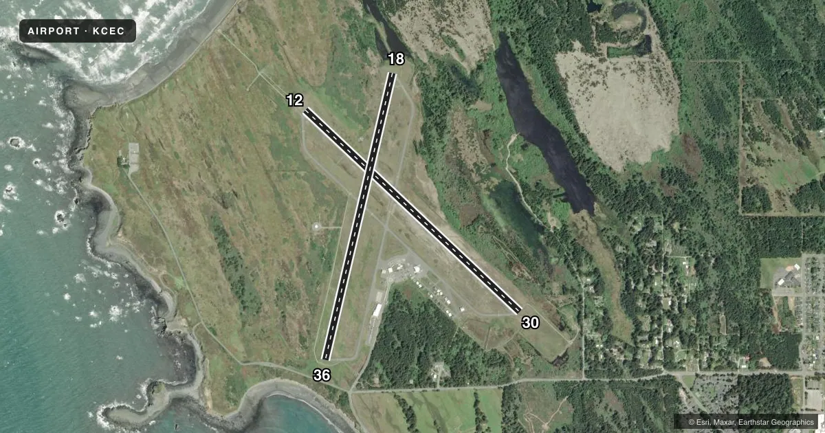
Runways & pattern
Full pagePattern entry · RWY 12
LEFT TRAFFIC| Runway | Heading (°M) | Length | Surface | Traffic |
|---|---|---|---|---|
| 12/30 | 119° / 299° | 5,002 ft | ASPH | Standard L |
| 18/36 | 179° / 359° | 5,000 ft | ASPH | Standard L |
Runway end performance
| End | TORA | TODA | ASDA | LDA | VGSI | Approach lights | Obstruction |
|---|---|---|---|---|---|---|---|
| 12 | 5,002' | 5,002' | 5,002' | 5,002' | — | MALSR | — |
| 30 | 5,002' | 5,002' | 5,002' | 5,002' | VASI 4-box left(3.5°) | — | 86', trees, 1520' from thr, 250' R of cntrln, slope 15 |
| 18 | 5,000' | 5,000' | 5,000' | 4,850' | — | — | 55', gnd, 1075' from thr, 250' R of cntrln, slope 15 |
| 36 | 4,850' | 4,850' | 4,850' | 4,850' | VASI 4-box left(3°) | — | 9', road, 350' from thr, 0' R of cntrln, slope 16 |
Declared distances in feet. TORA = takeoff run available, TODA = takeoff distance, ASDA = accelerate-stop, LDA = landing distance.
Airport sketch
Runways drawn to scale from FAA survey coordinates, rendered over satellite imagery. Not for navigation.
Approaches & charts
ILS · 1
Services on the field
Fuel grades, oxygen, maintenance, ramp storage and lighting — as declared to the FAA by the airport operator.
Fuel & services
- Fuel
- 100LLA
- Oxygen (bottled)
- Not available
- Oxygen (bulk)
- Not available
- Airframe repair
- Minor
- Power plant repair
- Minor
- Other services
- AFRT,AMB,CHTR,INSTR,RNTL,SALES,SURV
Ramp & ground
- Transient storage
- Tie-down
- Landing fee
- No fee published
- Customs
- Not available
- Lighting schedule
- SEE RMK
- Beacon schedule
- SS-SR
- Beacon
- White / Green (civil land)(WG)
- Wind indicator
- Lighted
- Segmented circle
- Yes
Fuel & FBOs
Cheapest 100LL and Jet A on the field and nearby. Always confirm with the FBO before taxi.
Airport notes
Surface conditions, obstructions, local procedures, lighting outages and other notes published with each FAA cycle.
General notes
- A 150 FT LGTD TWR 3300 FT W CEC VOR.
- BIRDS AND DEER ON & INVOF ARPT.
- RIDGE LNS OF SHIFTING SAND DUNES 30-50 FT AGL AND 1000 FT OFF APCH END RWY 18.
- TSNT PRKG RAMP ESTD WGT LIMIT 20000 LBS, FBO RAMP ESTD WGT LIMIT 60000 LBS.
- FOR CD IF UNA TO CTC ON FSS FREQ, CTC SEATTLE ARTCC AT 253-351-3694.
Lighting notes
- ACTVT MALSR RWY 12; REIL RWY 18, 36, & 30; HIRL RWY 12/30; MIRL RWY 18/36 - CTAF.
Runway surface & condition
- 12/30PCR VALUE: 103/F/C/Y/T
- 18/36PCR VALUE: 103/F/C/Y/T
Other notes
- PRIOR TO 15 MAY 59
- PPR FOR UNSKED ACR OPNS WITH MORE THAN 30 PSGR SEATS CALL AMGR 707-464-7288 OR 707-465-3804.
- 1OTR HRS FBO REQUIRES CALL OUT FEE.
VFR map & nearby airports
VFR sectional. Tap any ICAO chip to open that airport.
Key facts · KCEC
Answer card- ICAO
- KCEC
- Name
- JACK MC NAMARA FLD
- Location
- CRESCENT CITY, CALIFORNIA
- Elevation
- 60.7 ft MSL
- Traffic pattern altitude
- 1,060.7 ft MSL (1,000 AGL)
- Control tower
- Non-towered (use CTAF)
- Total runways
- 2
- Longest runway
- 12/30 · 5,002 ft
- Published ILS approaches
- 1
- Published frequencies
- 2
- Magnetic variation
- 14°
- Current flight rules
- MVFR
- Current wind
- 000° at 0 kt
- Favored runway now
- –
Jack Mc Namara Fld sits in Crescent City, California near the coast at 60.7 ft MSL. It has two asphalt runways. The longest is runway 12/30 at 5,002 ft. There is no control tower. CTAF and UNICOM are both 122.8. Runway 12 has an ILS and the published lighting setup includes MALSR on 12. Pattern altitude is not published. Use the standard 1,000 ft AGL pattern for light piston aircraft unless the current Chart Supplement says otherwise.
Cal-Ore Life Flight is on the field. It carries 100LL and Jet A. Call ahead at (707) 465-3804 if you need current FBO details. The airport has some operational points that matter on a first visit. There are ridgelines of shifting sand dunes near the approach end of runway 18. They sit 30 to 50 ft above ground level and are about 1,000 ft from the threshold. Birds and deer are also reported on and near the airport. The field also has published weight limits for transient and FBO ramps. Check those before arrival if you are bringing a heavier aircraft. The airport sits in a coastal environment, so expect changing weather and keep an eye on runway choice and approach setup.