METAR & TAF 5S6
5S6 does not publish a METAR.
Showing the nearest reporting station: KOTH (SOUTHWEST OREGON RGNL) · 35.6 NM away. Conditions at 5S6 may differ.
METAR · KOTH
Observed 12:54Z
KOTH 221254Z 16005KT 10SM OVC003 13/13 A2994
- Wind
- 160° @ 5 kt
- Visibility
- 10 SM
- Temp / Dew
- 13°C / 13°C
- Altimeter
- 29.94 inHg
- Clouds
- OVC
- Density alt
- -14 ft
- Ceiling
- 300 ft AGL
- Rules
- LIFR
Airport info & contacts
Manager on record, flight service, ARTCC, attendance schedule and pattern altitude — published by the FAA and refreshed every 28 days.
Location
- From city
- 4 NM NW
- VFR sectional
- KLAMATH FALLS
- ARTCC
- ZSE · SEATTLE
- NOTAM facility
- MMV (NOTAM-D)
Airport manager
- Name
- ANTHONY BEACH
- Phone
- 503-378-4880
- Address
- 3040 25TH ST SE, SALEM OR 97302
Flight service · Hours
- FSS MMV
- MC MINNVILLE1-800-WX-BRIEF
- Attendance
- Unattended
Frequencies
Tap any row to copy the frequency to your clipboard.
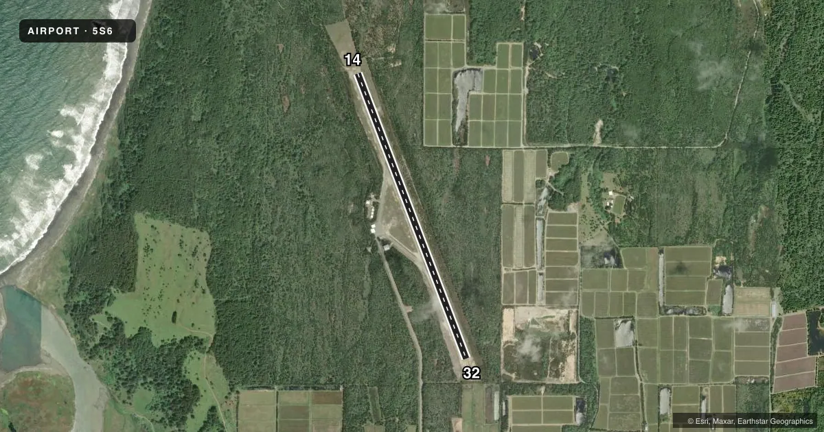
Runways & pattern
Full pagePattern entry · RWY 14
LEFT TRAFFICRunway end performance
| End | TORA | TODA | ASDA | LDA | VGSI | Approach lights | Obstruction |
|---|---|---|---|---|---|---|---|
| 14 | — | — | — | — | — | — | 14', trees, 436' from thr, 0' R of cntrln, slope 16 |
| 32 | — | — | — | — | — | — | 15', brush, 424' from thr, 0' R of cntrln, slope 14 |
Declared distances in feet. TORA = takeoff run available, TODA = takeoff distance, ASDA = accelerate-stop, LDA = landing distance.
Airport sketch
Runways drawn to scale from FAA survey coordinates, rendered over satellite imagery. Not for navigation.
Approaches & charts
Services on the field
Fuel grades, oxygen, maintenance, ramp storage and lighting — as declared to the FAA by the airport operator.
Fuel & services
- Fuel
- Not available
Ramp & ground
- Transient storage
- Tie-down
- Landing fee
- No fee published
- Customs
- Not available
- Lighting schedule
- SEE RMK
- Beacon schedule
- SS-SR
- Beacon
- White / Green (civil land)(WG)
- Wind indicator
- Yes
- Segmented circle
- Yes
Fuel & FBOs
Cheapest 100LL and Jet A on the field and nearby. Always confirm with the FBO before taxi.
Airport notes
Surface conditions, obstructions, local procedures, lighting outages and other notes published with each FAA cycle.
Lighting notes
- ACTVT LGT - CTAF.
Approach & departure obstructions
- 14113 FT EITHER SIDE OF RWY BRUSH & TREES.
- 32115 FT FM RWY BRUSH & TREES BOTH SIDES.
- 14CTLG OBSTN EXCEEDS A 45 DEG SLP.
Other notes
- ESTABD PRIOR TO 1959.
- TOTAL: ACOUSTICAL COUNTER.
VFR map & nearby airports
VFR sectional. Tap any ICAO chip to open that airport.
Key facts · 5S6
Answer card- ICAO
- 5S6
- Name
- CAPE BLANCO STATE
- Location
- SIXES, OREGON
- Elevation
- 202 ft MSL
- Traffic pattern altitude
- 1,202 ft MSL (1,000 AGL)
- Control tower
- Non-towered (use CTAF)
- Total runways
- 1
- Longest runway
- 14/32 · 5,100 ft
- Published ILS approaches
- 0
- Published frequencies
- 1
- Magnetic variation
- 18°
- Current flight rules
- LIFR
- Current wind
- 160° at 5 kt
- Favored runway now
- RWY 14
Cape Blanco State Airport sits in Sixes, Oregon. The field elevation is 202 ft MSL. It has one runway. Runway 14/32 is 5,100 ft of asphalt, which gives you room for most light piston traffic and some larger aircraft within performance limits. There is no control tower. CTAF is 122.9. Activated lighting is available on CTAF, so night operations depend on pilot-controlled lighting. No ILS approaches are published here.
The pattern altitude is not published. Use the standard 1,000 ft AGL pattern unless the current Chart Supplement or local procedures say otherwise. That puts the light-aircraft pattern at 1,202 ft MSL. The published remarks also note brush and trees near both ends of the runway. Expect them 113 ft off either side of runway 14. Expect brush and trees 115 ft from runway 32 on both sides. There is also a cataloged obstruction near runway 14 that exceeds a 45 degree slope. That makes a stabilized approach and a close look at winds and performance important, especially if you are new to the field.
No on-field FBOs are listed. Check with the airport operator directly or call the field on CTAF for current services before you go. The airport has been established since before 1959. For current noise, curfew, or other local operating notes, check the current FAA Chart Supplement before flying in.