METAR & TAF 16S
16S does not publish a METAR.
Showing the nearest reporting station: KRBG (ROSEBURG RGNL) · 14.6 NM away. Conditions at 16S may differ.
METAR · KRBG
Observed 12:53Z
KRBG 271253Z AUTO 00000KT 10SM CLR 12/10 A3010 RMK AO2 SLP190 T01220100
- Wind
- 000° @ 0 kt
- Visibility
- 10 SM
- Temp / Dew
- 12°C / 10°C
- Altimeter
- 30.10 inHg
- Clouds
- CLR
- Density alt
- 184 ft
- Ceiling
- Unlimited
- Rules
- VFR
Airport info & contacts
Manager on record, flight service, ARTCC, attendance schedule and pattern altitude — published by the FAA and refreshed every 28 days.
Location
- From city
- 2 NM SW
- VFR sectional
- KLAMATH FALLS
- Pattern altitude
- 981 ft AGL · 1,600 ft MSL
- ARTCC
- ZSE · SEATTLE
- NOTAM facility
- MMV (NOTAM-D)
Airport manager
- Name
- LONNIE RAINEVILLE, CITY MGR
- Phone
- 541-863-3171
- Address
- PO BOX 940, MYRTLE CREEK OR 97457
Flight service · Hours
- FSS MMV
- MC MINNVILLE1-800-WX-BRIEF
- Attendance
- Unattended
Frequencies
Tap any row to copy the frequency to your clipboard.
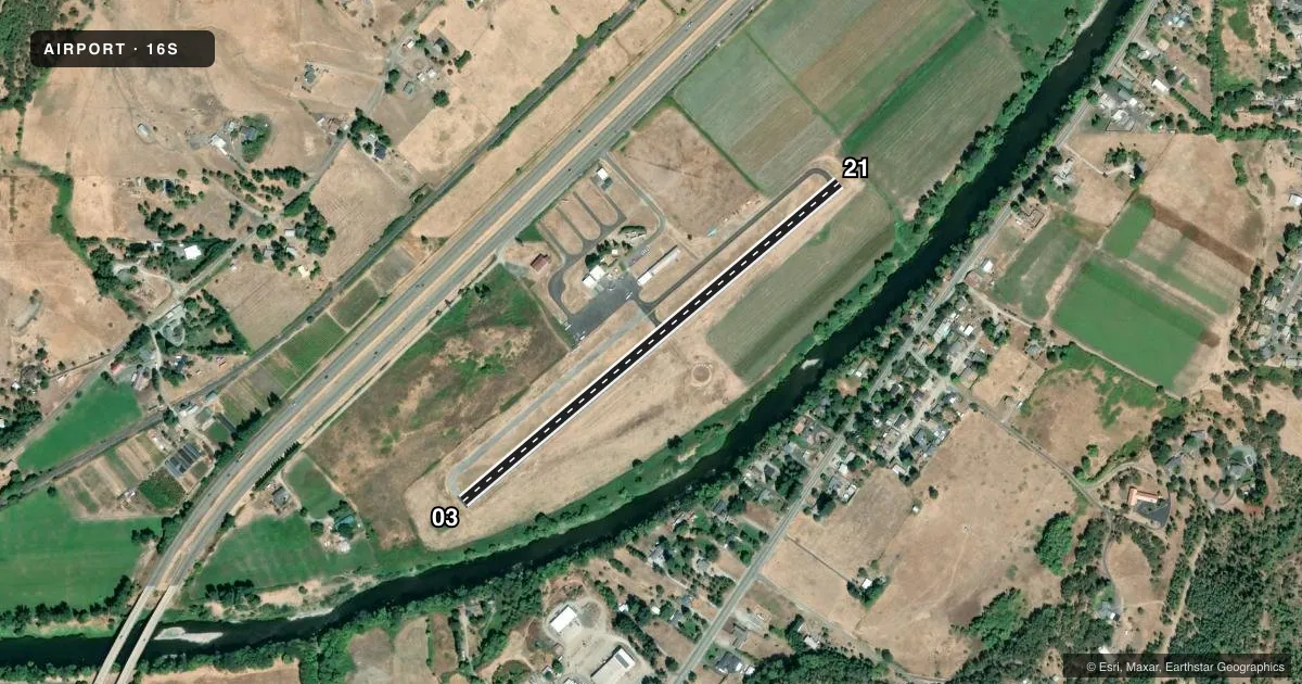
Runways & pattern
Full pagePattern entry · RWY 03
RIGHT TRAFFICRunway end performance
| End | TORA | TODA | ASDA | LDA | VGSI | Approach lights | Obstruction |
|---|---|---|---|---|---|---|---|
| 03 | — | — | — | — | PAPI 2-box left(4°) | — | 11', brush, 269' from thr, 60' R of cntrln, slope 6 |
| 21 | — | — | — | — | — | — | 112', trees, 1943' from thr, 70' R of cntrln, slope 15 |
Declared distances in feet. TORA = takeoff run available, TODA = takeoff distance, ASDA = accelerate-stop, LDA = landing distance.
Airport sketch
Runways drawn to scale from FAA survey coordinates, rendered over satellite imagery. Not for navigation.
Approaches & charts
Services on the field
Fuel grades, oxygen, maintenance, ramp storage and lighting — as declared to the FAA by the airport operator.
Fuel & services
- Fuel
- Not available
- Oxygen (bottled)
- Not available
- Oxygen (bulk)
- Not available
- Airframe repair
- Not available
- Power plant repair
- Not available
Ramp & ground
- Transient storage
- Tie-down
- Landing fee
- No fee published
- Customs
- Not available
- Lighting schedule
- SEE RMK
- Beacon schedule
- SS-SR
- Beacon
- White / Green (civil land)(WG)
- Wind indicator
- Lighted
- Segmented circle
- Yes
Fuel & FBOs
Cheapest 100LL and Jet A on the field and nearby. Always confirm with the FBO before taxi.
Airport notes
Surface conditions, obstructions, local procedures, lighting outages and other notes published with each FAA cycle.
General notes
- 198 FT LGTD TOWER 1.3 NM NORTH - NORTHWEST MSL ELEV 2122 OBSTRUCTS VFR ROUTE.
- TERRAIN RISES TO 2200 FT MSL WITHIN 2 MILES ON EACH SIDE OF RY.
- FOR CD CTC SEATTLE ARTCC AT 253-351-3694.
Lighting notes
- ACTIVATE MIRL RYS 03/21, REIL RY 03 & PAPI RY 03- CTAF.
VFR map & nearby airports
VFR sectional. Tap any ICAO chip to open that airport.
Key facts · 16S
Answer card- ICAO
- 16S
- Name
- MYRTLE CREEK MUNI
- Location
- MYRTLE CREEK, OREGON
- Elevation
- 619 ft MSL
- Traffic pattern altitude
- 1,600 ft MSL (981 AGL)
- Control tower
- Non-towered (use CTAF)
- Total runways
- 1
- Longest runway
- 03/21 · 2,600 ft
- Published ILS approaches
- 0
- Published frequencies
- 2
- Magnetic variation
- 18°
- Current flight rules
- VFR
- Current wind
- 000° at 0 kt
- Favored runway now
- –
Myrtle Creek Muni sits in Myrtle Creek, Oregon. Field elevation is 619 ft MSL. The airport has one runway, 03/21 and it is 2,600 ft long on asphalt. There is no control tower. CTAF and UNICOM are both 122.7.
Pattern altitude is 981 ft AGL, which is 1,600 ft MSL. No ILS approaches are published here, so plan with that in mind if the weather is marginal. The runway lighting is pilot-controlled on 122.7. That includes medium intensity runway lights on 03 and 21, runway end identifier lights on 03 and PAPI on 03.
Terrain is a real factor here. Published remarks say terrain rises to 2,200 ft MSL within 2 miles on each side of the runway. There is also a lighted tower 1.3 NM north-northwest of the field at 2,122 ft MSL. For clearance delivery, Seattle ARTCC is listed at 253-351-3694. No on-field FBOs are listed. Verify services with the airport operator or call ahead before you go. A first-time pilot should treat this as a small non-towered field with nearby terrain. Pay close attention to departure planning, especially if ceilings are low or winds are pushing you toward the higher ground.