METAR & TAF 64S
64S does not publish a METAR.
Showing the nearest reporting station: KMFR (ROGUE VALLEY INTL/MEDFORD) · 27.9 NM away. Conditions at 64S may differ.
METAR · KMFR
Observed 05:53Z
KMFR 270553Z AUTO 03005KT 10SM CLR 23/07 A3003 RMK AO2 SLP159 T02330067 10339 20233 51026
- Wind
- 030° @ 5 kt
- Visibility
- 10 SM
- Temp / Dew
- 23°C / 7°C
- Altimeter
- 30.03 inHg
- Clouds
- CLR
- Density alt
- 4,020 ft
- Ceiling
- Unlimited
- Rules
- VFR
Airport info & contacts
Manager on record, flight service, ARTCC, attendance schedule and pattern altitude — published by the FAA and refreshed every 28 days.
Location
- From city
- 1 NM S
- VFR sectional
- KLAMATH FALLS
- ARTCC
- ZSE · SEATTLE
- NOTAM facility
- MMV (NOTAM-D)
Airport manager
- Name
- STATE AIRPORTS MANAGER
- Phone
- 503-378-4880
- Address
- 3040 25TH ST, SE, SALEM OR 97302-1125
Flight service · Hours
- FSS MMV
- MC MINNVILLE1-800-WX-BRIEF
- Attendance
- Unattended
Frequencies
Tap any row to copy the frequency to your clipboard.
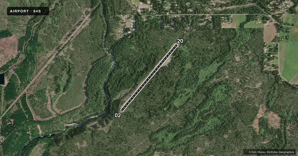
Runways & pattern
Full pagePattern entry · RWY 02
LEFT TRAFFICRunway end performance
| End | TORA | TODA | ASDA | LDA | VGSI | Approach lights | Obstruction |
|---|---|---|---|---|---|---|---|
| 02 | — | — | — | — | — | — | 30', trees, 201' from thr, 79' R of cntrln, slope 0 |
| 20 | — | — | — | — | — | — | 56', trees, 333' from thr, 135' R of cntrln, slope 2 |
Declared distances in feet. TORA = takeoff run available, TODA = takeoff distance, ASDA = accelerate-stop, LDA = landing distance.
Airport sketch
Runways drawn to scale from FAA survey coordinates, rendered over satellite imagery. Not for navigation.
Approaches & charts
Services on the field
Fuel grades, oxygen, maintenance, ramp storage and lighting — as declared to the FAA by the airport operator.
Fuel & services
- Fuel
- Not available
- Oxygen (bottled)
- Not available
- Oxygen (bulk)
- Not available
- Airframe repair
- Not available
- Power plant repair
- Not available
Ramp & ground
- Transient storage
- Tie-down
- Landing fee
- No fee published
- Customs
- Not available
- Lighting schedule
- SEE RMK
- Beacon schedule
- SS-SR
- Beacon
- White / Green (civil land)(WG)
- Wind indicator
- Yes
- Segmented circle
- Yes
Fuel & FBOs
Cheapest 100LL and Jet A on the field and nearby. Always confirm with the FBO before taxi.
Airport notes
Surface conditions, obstructions, local procedures, lighting outages and other notes published with each FAA cycle.
General notes
- 80 FT - 100 FT TREES WI 200 FT OF RWY CNTRLN BOTH SIDES OF RWY.
- TURF TIE DOWN AREA ROUGH.
- IREG WINTER MAINT; ARPT MAY BE CLSD BY SN.
- SFC CONDS NOT RPRTD.
- FOR CD CTC SEATTLE ARTCC AT 253-351-3694.
Lighting notes
- ACTVT LIRL 02/20 - CTAF.
Approach & departure obstructions
- 0270 FT UNLGTD TREES ABEAM THLD 120 FT L OF CNTRLN.
- 2023 FT TREES 79 FT RIGHT OF RWY FM 0 TO 200 FT.
- 02CTLG OBSTN EXCEEDS 45 DEG SLP.
Other notes
- NSTD CIRCLE MRKGS; TIRES PAINTED WHITE AND ORANGE.
VFR map & nearby airports
VFR sectional. Tap any ICAO chip to open that airport.
Key facts · 64S
Answer card- ICAO
- 64S
- Name
- PROSPECT STATE
- Location
- PROSPECT, OREGON
- Elevation
- 2,578 ft MSL
- Traffic pattern altitude
- 3,578 ft MSL (1,000 AGL)
- Control tower
- Non-towered (use CTAF)
- Total runways
- 1
- Longest runway
- 02/20 · 4,000 ft
- Published ILS approaches
- 0
- Published frequencies
- 2
- Magnetic variation
- 18°
- Current flight rules
- VFR
- Current wind
- 030° at 5 kt
- Favored runway now
- RWY 02
Prospect State Airport sits in Prospect, Oregon at 2,578 ft MSL. It has one runway, 02/20, with a longest length of 4,000 ft on asphalt. The field is non-towered. CTAF and UNICOM are both 122.8. No ILS approaches are published here.
Pattern altitude is not published. Use 1,000 ft AGL as the standard light piston pattern unless the current Chart Supplement says otherwise. The airport has low intensity runway lights on 02/20. They are controlled on CTAF. That helps for night work. You still need to verify the field is open before you go. Winter can be a factor here. Published remarks say snow may close the airport. Maintenance can be irregular.
This is a terrain and obstacle field. Trees run close to the runway environment on both sides. There are also published obstacles near both ends, including trees near runway 02 and a steep obstacle note off the departure path. First-time pilots should plan a careful arrival. Keep the climb performance honest. Brief the departure before taxi. There are no on-field FBOs listed. Check with the airport operator or the FBO directly by phone for current services. For clearance delivery, contact Seattle ARTCC at 253-351-3694.