METAR & TAF 3S6
3S6 does not publish a METAR.
Showing the nearest reporting station: KRBG (ROSEBURG RGNL) · 40.9 NM away. Conditions at 3S6 may differ.
METAR · KRBG
Observed 12:53Z
KRBG 271253Z AUTO 00000KT 10SM CLR 12/10 A3010 RMK AO2 SLP190 T01220100
- Wind
- 000° @ 0 kt
- Visibility
- 10 SM
- Temp / Dew
- 12°C / 10°C
- Altimeter
- 30.10 inHg
- Clouds
- CLR
- Density alt
- 3,584 ft
- Ceiling
- Unlimited
- Rules
- VFR
Airport info & contacts
Manager on record, flight service, ARTCC, attendance schedule and pattern altitude — published by the FAA and refreshed every 28 days.
Location
- From city
- 2 NM S
- VFR sectional
- KLAMATH FALLS
- ARTCC
- ZSE · SEATTLE
- NOTAM facility
- MMV (NOTAM-D)
Airport manager
- Name
- OREGON DEPT OF AVIATION
- Phone
- 503-378-4880
- Address
- 3040 25TH STREET SE, SALEM OR 97302-1125
Flight service · Hours
- FSS MMV
- MC MINNVILLE1-800-WX-BRIEF
- Attendance
- Unattended
Frequencies
Tap any row to copy the frequency to your clipboard.
Runways & pattern
Full pagePattern entry · RWY 11
LEFT TRAFFICRunway end performance
| End | TORA | TODA | ASDA | LDA | VGSI | Approach lights | Obstruction |
|---|---|---|---|---|---|---|---|
| 11 | — | — | — | — | — | — | 101', trees, 789' from thr, 30' R of cntrln, slope 7 |
| 29 | — | — | — | — | — | — | 91', trees, 333' from thr, 30' R of cntrln, slope 3 |
Declared distances in feet. TORA = takeoff run available, TODA = takeoff distance, ASDA = accelerate-stop, LDA = landing distance.
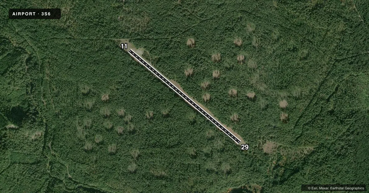
Airport sketch
Runways drawn to scale from FAA survey coordinates, rendered over satellite imagery. Not for navigation.
Approaches & charts
Services on the field
Fuel grades, oxygen, maintenance, ramp storage and lighting — as declared to the FAA by the airport operator.
Fuel & services
- Fuel
- Not available
- Oxygen (bottled)
- Not available
- Oxygen (bulk)
- Not available
- Airframe repair
- Not available
- Power plant repair
- Not available
Ramp & ground
- Transient storage
- Not published
- Landing fee
- No fee published
- Wind indicator
- Yes
- Segmented circle
- No
Fuel & FBOs
Cheapest 100LL and Jet A on the field and nearby. Always confirm with the FBO before taxi.
Airport notes
Surface conditions, obstructions, local procedures, lighting outages and other notes published with each FAA cycle.
General notes
- RY 11/29 HAS +120 FT TREES 250 FT EITHER SIDE OF CNTRLN.
- ARPT CLSD FROM 01 NOV UNTIL 01 MAY.
- ELK, DEER AND TURKEY ON AND INVOF ARPT.
- TREES 4-30' ALONG SOUTH SIDE OF RY WITHIN 50' OF CNTRLN.
- FOR CD CTC SEATTLE ARTCC AT 253-351-3694.
- SFC CONDS NOT RPRTD.
Runway surface & condition
- 11/29GRADED; 60 FT WIDE; SHOULDERS ROUGH & RUTTED.
Approach & departure obstructions
- 11RY 11/29 THLDS OUTLINED WITH WHITE TIRES.
- 29RY 29 22 FT WEATHER INSTRUMENTS AT 10 FT FRM RY END AND 60 FT R OF CNTRLN.
VFR map & nearby airports
VFR sectional. Tap any ICAO chip to open that airport.
Key facts · 3S6
Answer card- ICAO
- 3S6
- Name
- TOKETEE STATE
- Location
- CLEARWATER, OREGON
- Elevation
- 3,361 ft MSL
- Traffic pattern altitude
- 4,361 ft MSL (1,000 AGL)
- Control tower
- Non-towered (use CTAF)
- Total runways
- 1
- Longest runway
- 11/29 · 5,350 ft
- Published ILS approaches
- 0
- Published frequencies
- 1
- Magnetic variation
- 18°
- Current flight rules
- VFR
- Current wind
- 000° at 0 kt
- Favored runway now
- –
Toketee State Airport sits near Clearwater, Oregon. Field elevation is 3,361 ft MSL. The airport has one runway, 11/29, which is 5,350 ft long and turf. There is no control tower. No ILS approaches are published.
Pattern altitude is not published. Use 1,000 ft AGL for light piston operations unless the current FAA Chart Supplement says otherwise. The field is closed from November 1 until May 1. Plan around that seasonal closure before you launch.
Runway 11/29 is graded and 60 ft wide. The shoulders are rough and rutted. Trees line the south side of the runway within 50 ft of the centerline. There are also trees over 120 ft tall about 250 ft on either side of the centerline. Runway 29 has 22 ft weather instruments near the departure end. White tires mark the thresholds.
No on-field FBOs are listed here. CTAF is 122.9. For clearance delivery, contact Seattle ARTCC at 253-351-3694. Surface conditions are not reported, so check the current FAA Chart Supplement and call ahead if you need a current field status. Elk, deer and turkey are reported on and near the airport. Keep a sharp lookout on taxi and final.