METAR & TAF 5S0
5S0 does not publish a METAR.
Showing the nearest reporting station: KEUG (MAHLON SWEET FLD) · 37.9 NM away. Conditions at 5S0 may differ.
METAR · KEUG
Observed 03:54Z
KEUG 270354Z 23009KT 10SM FEW120 19/12 A3007 RMK AO2 SLP181 T01890117 $
- Wind
- 230° @ 9 kt
- Visibility
- 10 SM
- Temp / Dew
- 19°C / 12°C
- Altimeter
- 30.07 inHg
- Clouds
- FEW
- Density alt
- 2,021 ft
- Ceiling
- Unlimited
- Rules
- VFR
Airport info & contacts
Manager on record, flight service, ARTCC, attendance schedule and pattern altitude — published by the FAA and refreshed every 28 days.
Location
- From city
- 1 NM W
- VFR sectional
- KLAMATH FALLS
- ARTCC
- ZSE · SEATTLE
- NOTAM facility
- MMV (NOTAM-D)
Airport manager
- Name
- STATE AIRPORTS MGR.
- Phone
- 503-378-4880
- Address
- 3040 25TH ST, SE, SALEM OR 97310
Flight service · Hours
- FSS MMV
- MC MINNVILLE1-800-WX-BRIEF
- Attendance
- Unattended
Frequencies
Tap any row to copy the frequency to your clipboard.
Runways & pattern
Full pagePattern entry · RWY 27
LEFT TRAFFICRunway end performance
| End | TORA | TODA | ASDA | LDA | VGSI | Approach lights | Obstruction |
|---|---|---|---|---|---|---|---|
| 09 | — | — | — | — | — | — | 65', tree, 850' from thr, 87' R of cntrln, slope 10 |
| 27 | — | — | — | — | — | — | 28', road, 390' from thr, 0' R of cntrln, slope 6 |
Declared distances in feet. TORA = takeoff run available, TODA = takeoff distance, ASDA = accelerate-stop, LDA = landing distance.
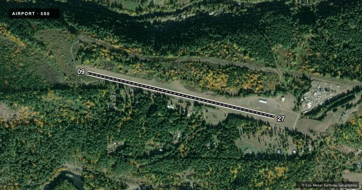
Airport sketch
Runways drawn to scale from FAA survey coordinates, rendered over satellite imagery. Not for navigation.
Approaches & charts
Services on the field
Fuel grades, oxygen, maintenance, ramp storage and lighting — as declared to the FAA by the airport operator.
Fuel & services
- Fuel
- Not available
- Oxygen (bottled)
- Not available
- Oxygen (bulk)
- Not available
- Airframe repair
- Not available
- Power plant repair
- Not available
Ramp & ground
- Transient storage
- Tie-down
- Landing fee
- No fee published
- Customs
- Not available
- Wind indicator
- Yes
- Segmented circle
- Yes
Fuel & FBOs
Cheapest 100LL and Jet A on the field and nearby. Always confirm with the FBO before taxi.
Airport notes
Surface conditions, obstructions, local procedures, lighting outages and other notes published with each FAA cycle.
General notes
- FOR CD CTC SEATTLE ARTCC AT 253-351-3694.
- USFS HELICOPTERS ACTIVE INVOF ARPT DURING FIRE SEASON.
- DEER AND ELK ON AND INVOF ARPT.
- IRREGULAR WINTER MAINTENANCE; ARPT MAY BE CLOSED BY SNOW.
- SURFACE CONDITIONS NOT REPORTED.
Approach & departure obstructions
- 09RWY 09 +35 FT TREES; 70FT FM RY END 72 FT RIGHT.
- 27TERRAIN RISES SMOOTHLY AT 14:1 FM RY END TO +14 FT AT 200 FT FM RY & CONTINUES TO RISE TO +65 FT AT 920 FT FM RY END ON CNTRLN.
- 09BEYOND ROAD SLOPE IS 8:1 BASED ON 130' TREE AT 1275' FROM RUNWAY END AND 100' RIGHT OF CENTERLINE.
Other notes
- SEGMENTED CIRCLE MKD WITH ORANGE AND WHITE TIRES.
- 09/27NUMEROUS AREAS OF UNSEALED LONGITUDINAL AND TRANSVERSE CRACKING ALONG FULL LENGTH OF RUNWAY.
VFR map & nearby airports
VFR sectional. Tap any ICAO chip to open that airport.
Key facts · 5S0
Answer card- ICAO
- 5S0
- Name
- OAKRIDGE STATE
- Location
- OAKRIDGE, OREGON
- Elevation
- 1,393 ft MSL
- Traffic pattern altitude
- 2,393 ft MSL (1,000 AGL)
- Control tower
- Non-towered (use CTAF)
- Total runways
- 1
- Longest runway
- 09/27 · 3,610 ft
- Published ILS approaches
- 0
- Published frequencies
- 1
- Magnetic variation
- 19°
- Current flight rules
- VFR
- Current wind
- 230° at 9 kt
- Favored runway now
- RWY 27
Oakridge State (5S0) sits in Oakridge, Oregon. Field elevation is 1,393 ft MSL. The airport has one runway, 09/27, which is 3,610 ft long and paved. There is no control tower. CTAF is 122.9. No ILS approaches are published here. Pattern altitude is not published, so use the standard 1,000 ft AGL for light piston operations unless the current Chart Supplement says otherwise.
This is a field where the runway environment matters. Published remarks note unsealed cracking along the full length of the runway. Surface conditions are not reported. Runway 09 has 35-foot trees close off the departure end. Runway 27 has rising terrain off the end of the runway. The slope continues up from the centerline. Deer and elk are reported on and near the airport. USFS helicopters are active in the area during fire season. Winter maintenance is irregular. The airport may be closed by snow.
There are no on-field FBOs listed. Plan on verifying services with the airport operator or the FBO directly by phone before you go. For clearance delivery, contact Seattle ARTCC at 253-351-3694. The segmented circle is marked with orange and white tires. If you are coming in for the first time, brief the terrain, wildlife and runway condition before you launch.