METAR & TAF 77S
Current METAR
Observed 04:35Z
K77S 270435Z AUTO 24005KT 10SM CLR 19/12 A3007 RMK A01
- Wind
- 240° @ 5 kt
- Visibility
- 10 SM
- Temp / Dew
- 19°C / 12°C
- Altimeter
- 30.07 inHg
- Clouds
- CLR
- Density alt
- 965 ft
- Ceiling
- Unlimited
- Rules
- VFR
Airport info & contacts
Manager on record, flight service, ARTCC, attendance schedule and pattern altitude — published by the FAA and refreshed every 28 days.
Location
- From city
- 1 NM NE
- VFR sectional
- KLAMATH FALLS
- Pattern altitude
- 865 ft AGL · 1,406 ft MSL
- ARTCC
- ZSE · SEATTLE
- NOTAM facility
- MMV (NOTAM-D)
Airport manager
- Name
- SHELLY HUMBLE
- Phone
- 541-895-2913
- Address
- 83501 N. MELTON ROAD, CRESWELL OR 97426
Flight service · Hours
- FSS MMV
- MC MINNVILLE1-800-WX-BRIEF
- Attendance
- MON-FRI · 0900-1800
- SAT-SUN · 1100-1600
Frequencies
Tap any row to copy the frequency to your clipboard.
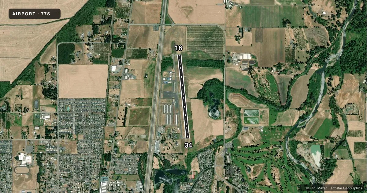
Runways & pattern
Full pagePattern entry · RWY 16
LEFT TRAFFICRunway end performance
| End | TORA | TODA | ASDA | LDA | VGSI | Approach lights | Obstruction |
|---|---|---|---|---|---|---|---|
| 16 | — | — | — | — | PAPI 2-box left(3.6°) | — | 13', tree, 248' from thr, 125' R of cntrln, slope 3 |
| 34 | — | — | — | — | PAPI 2-box left(4°) | — | 64', trees, 546' from thr, 175' R of cntrln, slope 5 |
Declared distances in feet. TORA = takeoff run available, TODA = takeoff distance, ASDA = accelerate-stop, LDA = landing distance.
Airport sketch
Runways drawn to scale from FAA survey coordinates, rendered over satellite imagery. Not for navigation.
Approaches & charts
Services on the field
Fuel grades, oxygen, maintenance, ramp storage and lighting — as declared to the FAA by the airport operator.
Fuel & services
- Fuel
- 100LLA
- Oxygen (bottled)
- Not available
- Oxygen (bulk)
- Not available
- Airframe repair
- Major
- Power plant repair
- Major
- Other services
- INSTR,PAJA,RNTL
Ramp & ground
- Transient storage
- Tie-down
- Landing fee
- No fee published
- Customs
- Not available
- Lighting schedule
- SEE RMK
- Beacon schedule
- SS-SR
- Beacon
- White / Green (civil land)(WG)
- Wind indicator
- Lighted
- Segmented circle
- Yes
Fuel & FBOs
Cheapest 100LL and Jet A on the field and nearby. Always confirm with the FBO before taxi.
Airport notes
Surface conditions, obstructions, local procedures, lighting outages and other notes published with each FAA cycle.
General notes
- RWY 34 CALM WIND RWY.
- PAEW ADJ TO RWY 16/34 WKENDS 0800-1600.
- BIRDS ON AND INVOF ARPT. BE AWARE MOWING ADJ RWY16/34 WEEKDAYS.
- BE AWARE OF SKYDIVERS XNG RWY.
- PARACHUTE JUMP AREA LOCATED EAST SIDE OF ARPT.
- CTC NUMBER FOR INFO AND UPDATES ABOUT SKYDIVING OPS 541-895-3029.
- FOR CD CTC CASCADE APCH AT 541-607-4674/4675, WHEN APCH CLSD CTC SEATTLE ARTCC AT 253-351-3694.
Lighting notes
- ACTIVATE PAPI RWY 16 & 34; MIRL RWY 16/34.- CTAF.
Fuel notes
- 100LLSELF SERVE FUEL AVAILABLE 24 HRS.
Approach & departure obstructions
- 34UNUSBL BYD 5 DEG RIGHT AND LEFT OF CNTRLN & BYD 1.5 NM FM THR.
VFR map & nearby airports
VFR sectional. Tap any ICAO chip to open that airport.
Key facts · 77S
Answer card- ICAO
- 77S
- Name
- HOBBY FLD
- Location
- CRESWELL, OREGON
- Elevation
- 541.2 ft MSL
- Traffic pattern altitude
- 1,406.2 ft MSL (865 AGL)
- Control tower
- Non-towered (use CTAF)
- Total runways
- 1
- Longest runway
- 16/34 · 3,102 ft
- Published ILS approaches
- 0
- Published frequencies
- 3
- Magnetic variation
- 15°
- Current flight rules
- VFR
- Current wind
- 240° at 5 kt
- Favored runway now
- RWY 16
HOBBY FLD (77S) sits in Creswell, Oregon. Field elevation is 541.2 ft MSL. The airport has one runway, 16/34, which is 3,102 ft long and paved with asphalt. There is no control tower. Pattern altitude is 865 ft AGL, which is 1,406.2 ft MSL. No ILS approaches are published here, so plan for VFR work or the current non-ILS procedures in the charted data.
Creswell Airport is on the field. It carries AVGAS 100LL and Jet A. Self-serve 100LL is available 24 hours. For a first-time arrival, the main things to watch are the parachute activity east of the runway. Skydivers cross the runway. Birds are also in the area. Weekend jump operations run from 0800 to 1600 on the east side. Runway 34 is the calm wind runway. The visual glide slope indicators are unusable beyond 5 degrees right or left of centerline and beyond 1.5 NM from the threshold. Lighting for runways 16 and 34 is activated on CTAF. Check the current FAA Chart Supplement for any updated operating notes before you go.