METAR & TAF S12
Current METAR
Observed 06:30Z
KS12 270630Z AUTO 00000KT 10SM CLR 15/11 A3007 RMK AO2
- Wind
- 000° @ 0 kt
- Visibility
- 10 SM
- Temp / Dew
- 15°C / 11°C
- Altimeter
- 30.07 inHg
- Clouds
- CLR
- Density alt
- 95 ft
- Ceiling
- Unlimited
- Rules
- VFR
Airport info & contacts
Manager on record, flight service, ARTCC, attendance schedule and pattern altitude — published by the FAA and refreshed every 28 days.
Location
- From city
- 3 NM E
- VFR sectional
- SEATTLE
- ARTCC
- ZSE · SEATTLE
- NOTAM facility
- MMV (NOTAM-D)
Airport manager
- Name
- ROBB ROMEO
- Phone
- 541-917-7605
- Address
- 310 NE WAVERLY DRIVE, ALBANY OR 97321
Flight service · Hours
- FSS MMV
- MC MINNVILLE1-800-WX-BRIEF
- Attendance
- 0800-1700
Frequencies
Tap any row to copy the frequency to your clipboard.
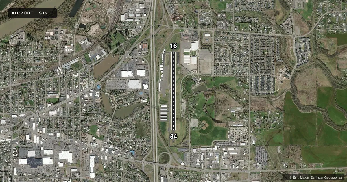
Runways & pattern
Full pagePattern entry · RWY 16
LEFT TRAFFICRunway end performance
| End | TORA | TODA | ASDA | LDA | VGSI | Approach lights | Obstruction |
|---|---|---|---|---|---|---|---|
| 16 | — | — | — | — | PAPI 2-box left(4°) | — | 13', road, 427' from thr, 148' R of cntrln, slope 17 |
| 34 | — | — | — | — | PAPI 2-box left(4°) | — | 80', trees, 1520' from thr, 0' R of cntrln, slope 16 |
Declared distances in feet. TORA = takeoff run available, TODA = takeoff distance, ASDA = accelerate-stop, LDA = landing distance.
Airport sketch
Runways drawn to scale from FAA survey coordinates, rendered over satellite imagery. Not for navigation.
Approaches & charts
Services on the field
Fuel grades, oxygen, maintenance, ramp storage and lighting — as declared to the FAA by the airport operator.
Fuel & services
- Fuel
- 100LL
- Oxygen (bottled)
- Not available
- Airframe repair
- Not available
- Power plant repair
- Not available
- Other services
- INSTR,RNTL,SALES
Ramp & ground
- Transient storage
- Tie-down
- Landing fee
- No fee published
- Customs
- Not available
- Lighting schedule
- SEE RMK
- Beacon schedule
- SS-SR
- Beacon
- White / Green (civil land)(WG)
- Wind indicator
- Lighted
- Segmented circle
- Yes
Fuel & FBOs
Cheapest 100LL and Jet A on the field and nearby. Always confirm with the FBO before taxi.
Airport notes
Surface conditions, obstructions, local procedures, lighting outages and other notes published with each FAA cycle.
General notes
- TWY MKD BY REFLECTORS. NON STD COLOR ON NORTH AND SOUTH ENDS.
- RWY 34 HAS A 160 FT OVERRUN.
- RWY 16 HAS A 497 FT OVERRUN.
- FOR CD CTC CASCADE APCH AT 541-607-4674/4675, WHEN APCH CLSD CTC SEATTLE ARTCC AT 253-351-3694.
Lighting notes
- ACTVT REIL RWY 16 & 34; PAPI RWY 16 & 34; MIRL RWY 16/34 - CTAF.
Approach & departure obstructions
- 34PAPI UNUSBL BYD 5 DEGS LEFT OF CNTRLN.
- 16RY 16 80 FT UNMARKED TREE AT 1530 FT ON CNTRLN AT 18:1.
- 3465 FT MKD PLINE AT 1575 FT ON CNTRLN AT 20:1.
Other notes
- ESTABD PRIOR TO 1959.
VFR map & nearby airports
VFR sectional. Tap any ICAO chip to open that airport.
Key facts · S12
Answer card- ICAO
- S12
- Name
- ALBANY MUNI
- Location
- ALBANY, OREGON
- Elevation
- 226.5 ft MSL
- Traffic pattern altitude
- 1,226.5 ft MSL (1,000 AGL)
- Control tower
- Non-towered (use CTAF)
- Total runways
- 1
- Longest runway
- 16/34 · 3,004 ft
- Published ILS approaches
- 0
- Published frequencies
- 4
- Magnetic variation
- 15°
- Current flight rules
- VFR
- Current wind
- 000° at 0 kt
- Favored runway now
- –
Albany Muni sits in Albany, Oregon at 226.5 ft MSL. It has one runway, 16/34, which is 3,004 ft long with asphalt pavement. The field is not towered. CTAF and UNICOM are both 122.725. No ILS approaches are published here.
Pattern altitude is not published. Use the standard 1,000 ft AGL pattern unless local procedures or current chart data say otherwise. The airport uses Cascade Approach for clearance delivery. Published remarks also note that runway 16 and runway 34 have runway end identifier lights, precision approach path indicators and medium intensity runway lights controlled by CTAF.
For a first-time pilot, the big items are the runway obstructions and the lighting setup. Runway 16 has an 80-foot unmarked tree obstruction on the centerline about 1,530 feet from the threshold. Runway 34 has a 65-foot marked power line obstruction on the centerline about 1,575 feet from the threshold. Taxiways are marked with reflectors that use nonstandard colors on the north and south ends. Infinite Air Center is on the field. It carries 100LL. Check the current FAA Chart Supplement for any noise or operational notes before flying in.