METAR & TAF 7S9
7S9 does not publish a METAR.
Showing the nearest reporting station: KUAO (AURORA STATE) · 4.2 NM away. Conditions at 7S9 may differ.
METAR · KUAO
Observed 09:53Z
KUAO 270953Z AUTO 00000KT 10SM CLR 13/11 A3009 RMK AO2 SLP188 T01330111
- Wind
- 000° @ 0 kt
- Visibility
- 10 SM
- Temp / Dew
- 13°C / 11°C
- Altimeter
- 30.09 inHg
- Clouds
- CLR
- Density alt
- -246 ft
- Ceiling
- Unlimited
- Rules
- VFR
Airport info & contacts
Manager on record, flight service, ARTCC, attendance schedule and pattern altitude — published by the FAA and refreshed every 28 days.
Location
- From city
- 3 NM E
- VFR sectional
- SEATTLE
- ARTCC
- ZSE · SEATTLE
- NOTAM facility
- MMV (NOTAM-D)
Airport manager
- Name
- GLENN LENHARDT
- Phone
- 503-651-2187
- Address
- 29502 S MERIDIAN RD, HUBBARD OR 97032
Flight service · Hours
- FSS MMV
- MC MINNVILLE1-800-WX-BRIEF
- Attendance
- TUE-SAT · 0900-1700
Frequencies
Tap any row to copy the frequency to your clipboard.
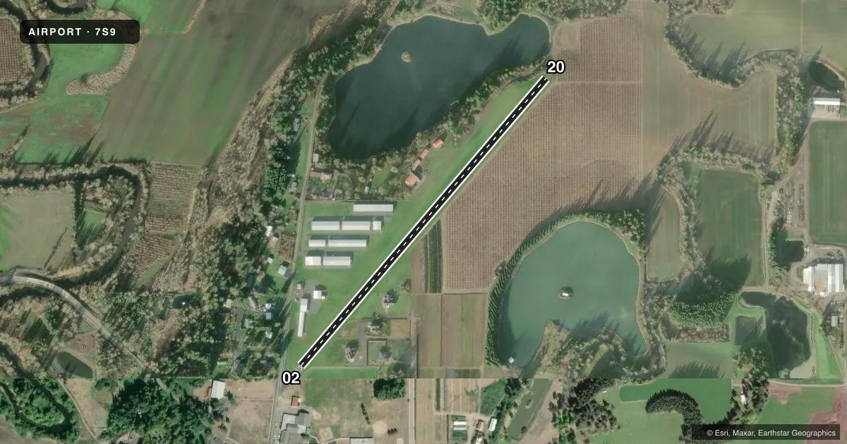
Runways & pattern
Full pagePattern entry · RWY 02
LEFT TRAFFICRunway end performance
| End | TORA | TODA | ASDA | LDA | VGSI | Approach lights | Obstruction |
|---|---|---|---|---|---|---|---|
| 02 | — | — | — | — | NSTD(7°) | — | 15', road, 201' from thr, 25' R of cntrln, slope 0 |
| 20 | — | — | — | — | NSTD(4°) | — | 74', trees, 763' from thr, 161' R of cntrln, slope 7 |
Declared distances in feet. TORA = takeoff run available, TODA = takeoff distance, ASDA = accelerate-stop, LDA = landing distance.
Airport sketch
Runways drawn to scale from FAA survey coordinates, rendered over satellite imagery. Not for navigation.
Approaches & charts
Services on the field
Fuel grades, oxygen, maintenance, ramp storage and lighting — as declared to the FAA by the airport operator.
Fuel & services
- Fuel
- 100LL
- Oxygen (bottled)
- Not available
- Oxygen (bulk)
- Not available
- Airframe repair
- Major
- Power plant repair
- Major
- Other services
- INSTR
Ramp & ground
- Transient storage
- Not published
- Landing fee
- No fee published
- Customs
- Not available
- Lighting schedule
- SS-SR
- Wind indicator
- Lighted
- Segmented circle
- No
Fuel & FBOs
Cheapest 100LL and Jet A on the field and nearby. Always confirm with the FBO before taxi.
Airport notes
Surface conditions, obstructions, local procedures, lighting outages and other notes published with each FAA cycle.
General notes
- RY 02 +6 FT FENCE 50-70' FT R OF THLD FLANKING FULL LENGTH OF RUNWAY.
- RY 02 HAS POWERLINE AT 730 FT.
- PARALLEL TWY WEST OF RY - GRASS.
- RY 02 DESIGNATED CALM WIND RY.
- RUNWAY 20 HAS NO END SAFETY AREA.
- RUNWAY 20 HAS A 6' FENCE AT 52' LEFT OF CENTERLINE FLANKING FULL LENGTH OF RUNWAY.
- FOR CD CTC PORTLAND APCH AT 503-493-7545.
Approach & departure obstructions
- 025' FENCE AT 28-200' FROM RUNWAY END AND 28-125 LEFT OF CENTERLINE. ROAD 130 FT TO 160 FT FM END OF RY; 99 FT LEFT OF CENTER LINE.
- 208' BRIARS AT 0-15' FROM RUNWAY END AND 5-100' RIGHT OF CENTERLINE.
- 02RY 02 NSTD VASI ONE FLASHING/STEADY LIGHT ON RIGHT SIDE OF RY.
- 20RY 20 NSTD VASI ONE FLASHING/STEADY LIGHT ON LEFT SIDE OF RY.
- 02BEYOND ROAD, 171' TREES AT 1558' FROM RWY END ON CNTRLN. OBSTRUCTION CLEARANCE SLOPE IS 8:1.
Other notes
- FILED FOR RECORD KEEPING PURPOSES ONLY.
- MANAGERTERRI COLEMAN LEASING MANAGER
- OWNERTERRI@AIRHAVEN.NET
VFR map & nearby airports
VFR sectional. Tap any ICAO chip to open that airport.
Key facts · 7S9
Answer card- ICAO
- 7S9
- Name
- LENHARDT AIRPARK
- Location
- HUBBARD, OREGON
- Elevation
- 165 ft MSL
- Traffic pattern altitude
- 1,165 ft MSL (1,000 AGL)
- Control tower
- Non-towered (use CTAF)
- Total runways
- 1
- Longest runway
- 02/20 · 2,956 ft
- Published ILS approaches
- 0
- Published frequencies
- 1
- Magnetic variation
- 19°
- Current flight rules
- VFR
- Current wind
- 000° at 0 kt
- Favored runway now
- –
Lenhardt Airpark sits in Hubbard, Oregon. The field elevation is 165 ft MSL. It has one runway. The longest runway is 2,956 ft of asphalt. There is no control tower. CTAF is 122.9. No ILS approaches are published here.
Pattern altitude is not published. Use 1,000 ft AGL for light piston operations unless the current Chart Supplement says otherwise. AirHaven at Lenhardt Airpark is on the field. It carries AVGAS 100LL. If you need current fuel or ramp details, call the FBO directly at (503) 651-2187.
This is a small non-towered field with some runway-specific caution items. Runway 02 has a nonstandard VASI on the right side. There are 171-foot trees beyond the road on centerline for Runway 02. Runway 20 has briars near the departure end. There is also a fence close to the runway on both ends. A grass parallel taxiway is west of the runway. Check the current Chart Supplement before you go. The published remarks also note a powerline on the Runway 02 side. For clearance delivery, Portland Approach is listed at 503-493-7545.