METAR & TAF KMMV
Current METAR
Observed 05:53Z
KMMV 270553Z AUTO 22008KT 10SM CLR 16/11 A3006 RMK AO2 SLP176 T01560111 10256 20156 51008 $
- Wind
- 220° @ 8 kt
- Visibility
- 10 SM
- Temp / Dew
- 16°C / 11°C
- Altimeter
- 30.06 inHg
- Clouds
- CLR
- Density alt
- 148 ft
- Ceiling
- Unlimited
- Rules
- VFR
Airport info & contacts
Manager on record, flight service, ARTCC, attendance schedule and pattern altitude — published by the FAA and refreshed every 28 days.
Location
- From city
- 3 NM SE
- VFR sectional
- SEATTLE
- ARTCC
- ZSE · SEATTLE
- NOTAM facility
- MMV (NOTAM-D)
Airport manager
- Name
- JOHN PASKELL
- Phone
- 971-461-8616
- Address
- 4000 SE CIRRUS AVE, MC MINNVILLE OR 97128
Flight service · Hours
- FSS MMV
- MC MINNVILLE1-800-WX-BRIEF
- Attendance
- 1600-0100Z
Frequencies
Tap any row to copy the frequency to your clipboard.
Runways & pattern
Full pagePattern entry · RWY 22
LEFT TRAFFIC| Runway | Heading (°M) | Length | Surface | Traffic |
|---|---|---|---|---|
| 04/22Favored | 38° / 218° | 5,420 ft | ASPH | Standard L |
| 17/35 | 167° / 347° | 4,340 ft | ASPH | Standard L |
Runway end performance
| End | TORA | TODA | ASDA | LDA | VGSI | Approach lights | Obstruction |
|---|---|---|---|---|---|---|---|
| 04 | 5,420' | 5,420' | 5,320' | 5,320' | PAPI 4-box left(3°) | — | 54', trees, 1032' from thr, 354' R of cntrln, slope 15 |
| 22 | 5,420' | 5,420' | 5,420' | 5,420' | PAPI 4-box left(3°) | MALSR | 126', trees, 2655' from thr, 711' R of cntrln, slope 19 |
| 17 | — | — | — | — | — | — | 85', tree, 1808' from thr, 200' R of cntrln, slope 18 |
Declared distances in feet. TORA = takeoff run available, TODA = takeoff distance, ASDA = accelerate-stop, LDA = landing distance.
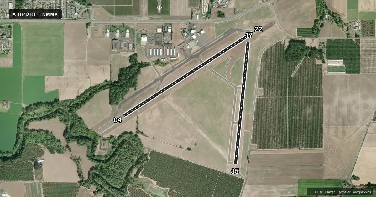
Airport sketch
Runways drawn to scale from FAA survey coordinates, rendered over satellite imagery. Not for navigation.
Approaches & charts
ILS · 1
Services on the field
Fuel grades, oxygen, maintenance, ramp storage and lighting — as declared to the FAA by the airport operator.
Fuel & services
- Fuel
- 100LLA
- Oxygen (bulk)
- High pressure
- Airframe repair
- Major
- Power plant repair
- Major
- Other services
- GLD,INSTR,RNTL,SALES,TOW
Ramp & ground
- Transient storage
- Tie-down
- Hangar
- Landing fee
- No fee published
- Customs
- Not available
- Lighting schedule
- SEE RMK
- Beacon schedule
- SS-SR
- Beacon
- White / Green (civil land)(WG)
- Wind indicator
- Lighted
- Segmented circle
- Yes
Fuel & FBOs
Cheapest 100LL and Jet A on the field and nearby. Always confirm with the FBO before taxi.
Airport notes
Surface conditions, obstructions, local procedures, lighting outages and other notes published with each FAA cycle.
General notes
- GLIDER OPS RWY 17/35; DALGT WI 8 NM BLW 8000 FT FEB - NOV.
- AFT HRS CALL OUT LIST POSTED ON FBO DOOR & VOICEMAIL.
- FOR CD CTC PORTLAND APCH AT 503-493-7545.
- NOISE ABATEMENT PROCS IN EFCT. NOISE SENSITIVE AREAS BDR ARPT NORTH ALG HWY 18. AVOID LOW-LEVEL & CONS OVR FLTS OF RESIDENTIAL AREAS SRNDG ARPT WHENEVER PSBL. NIGHTIME TGL OPS DISCOURAGED 0600-1400Z.
- ARPT CLSD AFT HVY SNOW. ARPT COND UNMNT 0100-1600Z DAILY.
- BIRD HAZ: MIGRATORY FLOCKS OF GEESE OCT-MAY. WATERFOWL, DEER, AND OTHER WILDLIFE MAY BE PRESENT ON & INVOF ARPT YEAR AROUND.
- FQT F/W & R/W TRNG ON & INVOF ARPT, INCL R/W ARR AND DEP FM TWY A & TWY D.
Lighting notes
- ACTVT MALSR RWY 22; REIL RWY 04; PAPI RWY 22; HIRL RWY 04/22 - CTAF. PAPI RWY 04 OPR CONSLY.
Fuel notes
- 100LL100LL CREDIT CARD SVC H24.
Approach & departure obstructions
- 0430 FT TREES ABM RWY END 450 FT L OF CNTRLN.
- 22CALM WIND RWY.
- 17CNTRLN MRKGS FADED.
- 35RWY NRS & CNRTLN MRKGS FADED.
Other notes
- ESTABD PRIOR TO 1959.
- AVBL MON-SAT.
- CTC FBO FOR AVBL.
VFR map & nearby airports
VFR sectional. Tap any ICAO chip to open that airport.
Key facts · KMMV
Answer card- ICAO
- KMMV
- Name
- MC MINNVILLE MUNI
- Location
- MC MINNVILLE, OREGON
- Elevation
- 162.6 ft MSL
- Traffic pattern altitude
- 1,162.6 ft MSL (1,000 AGL)
- Control tower
- Non-towered (use CTAF)
- Total runways
- 2
- Longest runway
- 04/22 · 5,420 ft
- Published ILS approaches
- 1
- Published frequencies
- 6
- Magnetic variation
- 19°
- Current flight rules
- VFR
- Current wind
- 220° at 8 kt
- Favored runway now
- RWY 22
Mc Minnville Muni is in Mc Minnville, Oregon. The field elevation is 162.6 ft MSL. It has two asphalt runways. The longest is runway 04/22 at 5,420 ft. There is no control tower, so expect CTAF/UNICOM traffic and a busy self-announce pattern. The published pattern altitude is not listed. Use the standard 1,000 ft AGL pattern for light piston aircraft unless local procedures or ATC say otherwise.
Runway 22 has the ILS and the published lighting setup for night work. MALSR is available on 22. Runway 04 has REILs. High intensity runway lights are on 04 and 22. They are controlled by CTAF. Runway 22 is also listed as the calm wind runway. That matters here because the airport sees frequent fixed-wing and rotary-wing training. Glider ops also occur on 17/35.
Potcake Aviation is on the field. It carries 100LL, Jet A and Jet A Prist. Noise abatement is published. Noise sensitive areas border the airport to the north along Highway 18. Avoid low-level overflights of nearby homes when you can. Watch for birds from October through May. Wildlife can be present year-round. There are also trees near runway 04, left of centerline near the departure end. Check the current FAA Chart Supplement for any current local procedures before you go.