METAR & TAF 4S9
4S9 does not publish a METAR.
Showing the nearest reporting station: KUAO (AURORA STATE) · 7.8 NM away. Conditions at 4S9 may differ.
METAR · KUAO
Observed 00:53Z
KUAO 270053Z 30004KT 10SM FEW120 26/12 A3002 RMK AO2 SLP164 T02560122
- Wind
- 300° @ 4 kt
- Visibility
- 10 SM
- Temp / Dew
- 26°C / 12°C
- Altimeter
- 30.02 inHg
- Clouds
- FEW
- Density alt
- 1,518 ft
- Ceiling
- Unlimited
- Rules
- VFR
Airport info & contacts
Manager on record, flight service, ARTCC, attendance schedule and pattern altitude — published by the FAA and refreshed every 28 days.
Location
- From city
- 20 NM S
- VFR sectional
- SEATTLE
- ARTCC
- ZSE · SEATTLE
- NOTAM facility
- MMV (NOTAM-D)
Airport manager
- Name
- OREGON DEPARTMENT OF AVIATION
- Phone
- 503-378-4880
- Address
- 3040 25TH STREET SE, SALEM OR 97302
Flight service · Hours
- FSS MMV
- MC MINNVILLE1-800-WX-BRIEF
- Attendance
- Unattended
Frequencies
Tap any row to copy the frequency to your clipboard.
Runways & pattern
Full pagePattern entry · RWY 32
LEFT TRAFFICRunway end performance
| End | TORA | TODA | ASDA | LDA | VGSI | Approach lights | Obstruction |
|---|---|---|---|---|---|---|---|
| 14 | — | — | — | — | PAPI 2-box left(3°) | — | 77', tree, 1002' from thr, 194' R of cntrln, slope 10 |
| 32 | — | — | — | — | PAPI 2-box left(3°) | — | 212', trees, 3059' from thr, 138' R of cntrln, slope 13 |
Declared distances in feet. TORA = takeoff run available, TODA = takeoff distance, ASDA = accelerate-stop, LDA = landing distance.
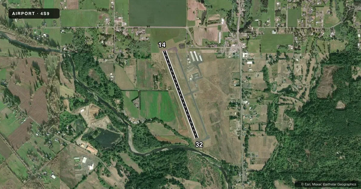
Airport sketch
Runways drawn to scale from FAA survey coordinates, rendered over satellite imagery. Not for navigation.
Approaches & charts
Services on the field
Fuel grades, oxygen, maintenance, ramp storage and lighting — as declared to the FAA by the airport operator.
Fuel & services
- Fuel
- 100LL
- Oxygen (bottled)
- Not available
- Oxygen (bulk)
- Not available
- Airframe repair
- Major
- Power plant repair
- Major
- Other services
- INSTR,PAJA,RNTL
Ramp & ground
- Transient storage
- Tie-down
- Landing fee
- No fee published
- Customs
- Not available
- Lighting schedule
- SEE RMK
- Beacon schedule
- SS-SR
- Beacon
- White / Green (civil land)(WG)
- Wind indicator
- Lighted
- Segmented circle
- Yes
Fuel & FBOs
Cheapest 100LL and Jet A on the field and nearby. Always confirm with the FBO before taxi.
Airport notes
Surface conditions, obstructions, local procedures, lighting outages and other notes published with each FAA cycle.
General notes
- RY 32 DESIGNATED CALM WIND RY.
- WILDLIFE ON & INVOF OF ARPT.
- BE ALERT FOR WEEKEND GLIDER ACTIVITY.
- SKYDIVING ACTIVITY ON AND IN VICINITY OF AIRPORT. LANDING ZONE 1400' EAST OF RUNWAY.
- FOR CD CTC PORTLAND APCH AT 503-493-7545.
Lighting notes
- ACTIVATE MIRL RY 14/32, TWY LGTS, & WINDCONE - CTAF. PAPI RYS 14 & 32 OPR 24 HRS.
Approach & departure obstructions
- 32PAPI OTS INDEF.
Other notes
- EXISTED PRIOR TO 1959.
VFR map & nearby airports
VFR sectional. Tap any ICAO chip to open that airport.
Key facts · 4S9
Answer card- ICAO
- 4S9
- Name
- MULINO STATE
- Location
- PORTLAND-MULINO, OREGON
- Elevation
- 259.9 ft MSL
- Traffic pattern altitude
- 1,259.9 ft MSL (1,000 AGL)
- Control tower
- Non-towered (use CTAF)
- Total runways
- 1
- Longest runway
- 14/32 · 3,425 ft
- Published ILS approaches
- 0
- Published frequencies
- 3
- Magnetic variation
- 19°
- Current flight rules
- VFR
- Current wind
- 300° at 4 kt
- Favored runway now
- RWY 32
Mulino State Airport sits in Portland-Mulino, Oregon. Field elevation is 259.9 ft MSL. The airport has one runway. Runway 14/32 is 3,425 ft of asphalt. There is no control tower. No ILS approaches are published. Pattern altitude is not published, so verify the current traffic pattern in the FAA Chart Supplement before you go. Runway 32 is the calm wind runway. The runway lights, taxiway lights and windcone are activated on CTAF. Precision approach path indicators are listed for both runway ends. The PAPI for runway 32 is out of service indefinitely.
Infinite Air Center is on the field. It carries AVGAS 100LL. For clearance delivery, contact Portland Approach at 503-493-7545. The airport has skydiving activity on and near the field. The landing zone is 1,400 feet east of the runway. Weekend glider activity is also published. Wildlife is present on and in the vicinity of the airport.
For a first-time pilot, the main things to plan for are mixed traffic and active local operations. Expect to stay sharp on CTAF. Use the current FAA Chart Supplement for any pattern details or other local procedures before arrival.