METAR & TAF 03S
03S does not publish a METAR.
Showing the nearest reporting station: KTTD (PORTLAND-TROUTDALE) · 11.5 NM away. Conditions at 03S may differ.
METAR · KTTD
Observed 23:53Z
KTTD 262353Z 00000KT 10SM CLR 26/12 A3000 RMK AO2 SLP160 T02610117 10261 20206 58017
- Wind
- 000° @ 0 kt
- Visibility
- 10 SM
- Temp / Dew
- 26°C / 12°C
- Altimeter
- 30.00 inHg
- Clouds
- CLR
- Density alt
- 2,094 ft
- Ceiling
- Unlimited
- Rules
- VFR
Airport info & contacts
Manager on record, flight service, ARTCC, attendance schedule and pattern altitude — published by the FAA and refreshed every 28 days.
Location
- From city
- 1 NM NE
- VFR sectional
- SEATTLE
- ARTCC
- ZSE · SEATTLE
- NOTAM facility
- MMV (NOTAM-D)
Airport manager
- Name
- GEORGIA HOFFMAN
- Phone
- (503) 516-6662
- Address
- 42313 SE ORAL HULL ROAD, SANDY OR 97055
Flight service · Hours
- FSS MMV
- MC MINNVILLE1-800-WX-BRIEF
- Attendance
- SR-SS
Frequencies
Tap any row to copy the frequency to your clipboard.
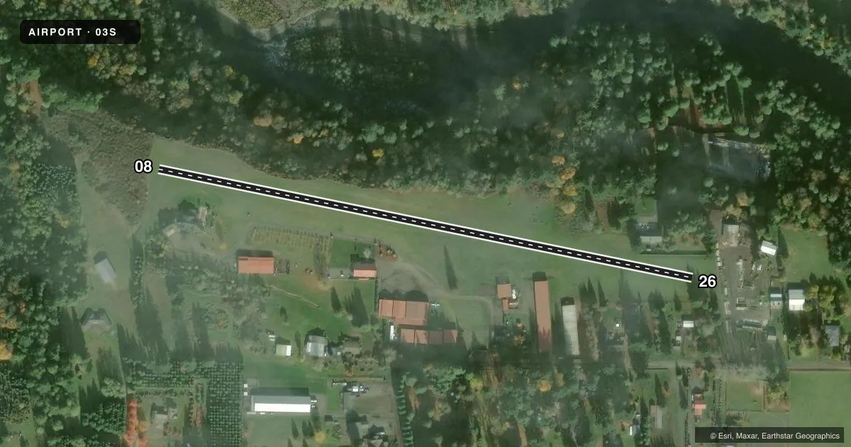
Runways & pattern
Full pagePattern entry · RWY 08
LEFT TRAFFICRunway end performance
| End | TORA | TODA | ASDA | LDA | VGSI | Approach lights | Obstruction |
|---|---|---|---|---|---|---|---|
| 08 | — | — | — | — | — | — | 142', trees, 583' from thr, 91' R of cntrln, slope 4 |
| 26 | — | — | — | — | — | — | 13', road, 5' from thr, 0' R of cntrln, slope 0 |
Declared distances in feet. TORA = takeoff run available, TODA = takeoff distance, ASDA = accelerate-stop, LDA = landing distance.
Airport sketch
Runways drawn to scale from FAA survey coordinates, rendered over satellite imagery. Not for navigation.
Approaches & charts
Services on the field
Fuel grades, oxygen, maintenance, ramp storage and lighting — as declared to the FAA by the airport operator.
Fuel & services
- Fuel
- Not available
- Oxygen (bottled)
- Not available
- Oxygen (bulk)
- Not available
- Airframe repair
- Major
- Power plant repair
- Minor
- Other services
- AGRI,AVNCS,SALES
Ramp & ground
- Transient storage
- Tie-down
- Hangar
- Landing fee
- No fee published
- Customs
- Not available
- Lighting schedule
- SEE RMK
- Wind indicator
- Yes
- Segmented circle
- No
Fuel & FBOs
Cheapest 100LL and Jet A on the field and nearby. Always confirm with the FBO before taxi.
Airport notes
Surface conditions, obstructions, local procedures, lighting outages and other notes published with each FAA cycle.
General notes
- RY 08/26 NOT MARKED.
- EXTSV ULTRALIGHT ACTVT ON AND INVOF ARPT.
- (A23) ULTRALIGHT OPERATIONS USE RIGHT TFC AND 600' AGL TPA; DO NOT LAND ON TURF ADJACENT TO RWY.
- FOR CD CTC PORTLAND APCH AT 503-493-7545.
- LRG TREES VCNTY.
- RWY 26 HAS A 6 FT FENCE 36 FT RIGHT OF CNTRLN ALG EDGE FM THR TO 300 FT.
- E SIDE OF RWY SAFETY AREA HAS A 5 FT GENTLE RISE IN MID OF SECTION.
Lighting notes
- PPR FOR LT ACTVT CODE. MUST HAVE FAM WITH AP.
Runway surface & condition
- 08/26RUNWAY LIGHTS DELINEATE ONLY 70' OF RUNWAY WIDTH.
Approach & departure obstructions
- 0810 FT CONC CONSTRUCTION BLX AT 20-80 FT FM RWY END LEFT AND RIGHT OF CNTRLN.
- 0860' TREE AT THRESHOLD AT 50' L OF CNTRLN. BEYOND ROAD, TREES TO 90' AT 400-730' FROM RWY END BOTH SIDES OF CNTRLN. OBSTRUCTION CLEARANCE SLOPE IS 8:1; +100 TREES AT 50-100' L OF CNTRLN FLANKING RWY.
Other notes
- ARPT ESTBD 1947.
VFR map & nearby airports
VFR sectional. Tap any ICAO chip to open that airport.
Key facts · 03S
Answer card- ICAO
- 03S
- Name
- SANDY RIVER
- Location
- SANDY, OREGON
- Elevation
- 704 ft MSL
- Traffic pattern altitude
- 1,704 ft MSL (1,000 AGL)
- Control tower
- Non-towered (use CTAF)
- Total runways
- 1
- Longest runway
- 08/26 · 2,115 ft
- Published ILS approaches
- 0
- Published frequencies
- 2
- Magnetic variation
- 19°
- Current flight rules
- VFR
- Current wind
- 000° at 0 kt
- Favored runway now
- –
Sandy River Airport sits in Sandy, Oregon at 704 ft MSL. It has one runway. Runway 08/26 is 2,115 ft of turf, so this is a short-field, grass-strip arrival rather than a paved-airport setup. The field is not towered. CTAF and UNICOM are both 122.8. No ILS approaches are published. The published pattern altitude is not listed, so verify the current Chart Supplement before you go. For ultralight traffic, the published pattern is right traffic at 600 ft AGL.
The runway is not marked. That matters here. Published remarks also call out a 60 ft tree near the 08 threshold, more trees close to the runway edges and a concrete block near the 08 end. Runway 26 has a fence 36 ft right of centerline near the edge. Large trees are in the area. Runway lights only delineate 70 ft of runway width. Prior permission is required for light activation code. Plan on getting current access details from the airport operator or the FBO directly by phone before night use.
There are no on-field FBOs listed. Contact the airport operator directly before arrival. Call the field on CTAF/UNICOM for current FBO availability. Portland Approach can help with clearance delivery at 503-493-7545. Expect a busy ultralight environment and keep a close eye on the terrain and obstructions on short final.