METAR & TAF KVUO
Current METAR
Observed 23:53Z
KVUO 262353Z AUTO 00000KT 10SM FEW120 26/11 A3003 RMK AO2 SLP168 T02560111 10261 20206 58016
- Wind
- 000° @ 0 kt
- Visibility
- 10 SM
- Temp / Dew
- 26°C / 11°C
- Altimeter
- 30.03 inHg
- Clouds
- FEW
- Density alt
- 1,219 ft
- Ceiling
- Unlimited
- Rules
- VFR
Airport info & contacts
Manager on record, flight service, ARTCC, attendance schedule and pattern altitude — published by the FAA and refreshed every 28 days.
Location
- From city
- 2 NM SW
- VFR sectional
- SEATTLE
- Pattern altitude
- 1,000 ft AGL · 1,029 ft MSL
- ARTCC
- ZSE · SEATTLE
- NOTAM facility
- VUO (NOTAM-D)
Airport manager
- Name
- MEREDITH FOX
- Phone
- 360-904-9007
- Address
- PO BOX 1995, VANCOUVER WA 98660
Flight service · Hours
- FSS SEA
- SEATTLE1-800-WX-BRIEF
- Attendance
- NOV-MAR · 0800-1700
- APR-OCT · 0800-1800
Frequencies
Tap any row to copy the frequency to your clipboard.
Runways & pattern
Full pagePattern entry · RWY 08
LEFT TRAFFICRunway end performance
| End | TORA | TODA | ASDA | LDA | VGSI | Approach lights | Obstruction |
|---|---|---|---|---|---|---|---|
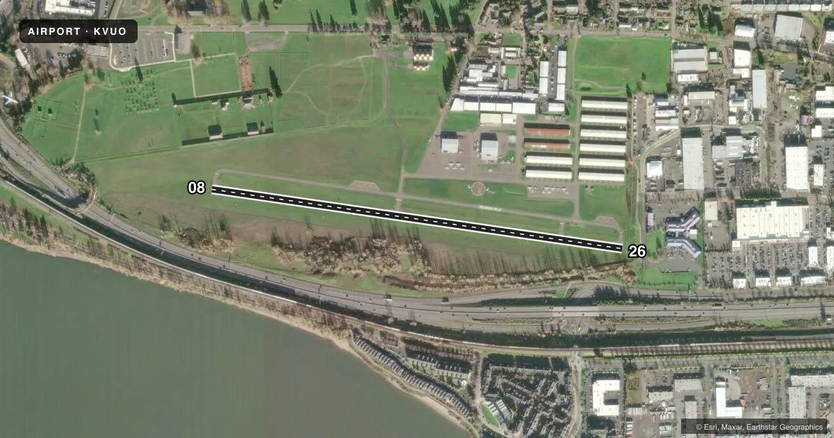
| 08 | 3,275' | 3,275' | 3,065' | 3,065' | VASI 4-box right(3.75°) | — | 218', brdg, 2647' from thr, 482' R of cntrln, slope 11 |
| 26 | 3,275' | 3,275' | 3,275' | 2,513' | PAPI 2-box right(4°) | — | 31', tree, 280' from thr, 0' R of cntrln, slope 2 |
Declared distances in feet. TORA = takeoff run available, TODA = takeoff distance, ASDA = accelerate-stop, LDA = landing distance.
Airport sketch
Runways drawn to scale from FAA survey coordinates, rendered over satellite imagery. Not for navigation.
Approaches & charts
Services on the field
Fuel grades, oxygen, maintenance, ramp storage and lighting — as declared to the FAA by the airport operator.
Fuel & services
- Fuel
- 100LL
- Oxygen (bulk)
- Low pressure
- Airframe repair
- Major
- Power plant repair
- Major
- Other services
- AVNCS,INSTR,RNTL
Ramp & ground
- Transient storage
- Tie-down
- Landing fee
- No fee published
- Customs
- Not available
- Lighting schedule
- SEE RMK
- Wind indicator
- Lighted
- Segmented circle
- Yes
Fuel & FBOs
Cheapest 100LL and Jet A on the field and nearby. Always confirm with the FBO before taxi.
Airport notes
Surface conditions, obstructions, local procedures, lighting outages and other notes published with each FAA cycle.
General notes
- GEESE ON & INVOF ARPT.
- ARR PRIOR TO ENTERING SFRA FAR 93.163 & DEP BFR TKOF - CTC CTAF.
- PPR TO ACESS AIR MUSEUM TXL.
- CTC AMGR FOR TSNT OVNGT FEES & PPR FOR EXTDD STAY.
- HEILICOPTER HOVER-TAXI OPS NA.
- FLY QUIET. WHEN OPERG OVER THE RWY CNTRLN OR RWY CNTRLN EXTDD - MNTN AT OR BLW 700 FT MSL DUE TO TFC & WAKE TURB FROM OVERFLYING ACFT TO/FROM PORTLAND INTL ARPT (PDX) RWY 10L/28R. PDX RWY 10L/28R EXTDD CNTRLN CROSSES PEARSON RWY 08 THLD. RWY 26 MNTN RWY HDG UNTIL PAST SMITH TWR. TURN RIGHT WEST OF TWR AND NATIONAL PARK. AVOID OVERFLYING THE FORT VANCOUVER STOCKADE (NATIONAL PARK), LCT 360 FT NORTH OF THE WEST END OF RWY 08. MNT CTAF 119.0.
Lighting notes
- ACTVT PAPI RWY 26; MIRL RWY 08/26 - CTAF.
Fuel notes
- 100LLSELF SVC CREDIT CARD H24.
Runway surface & condition
- 08/26STWY WEST END.
Approach & departure obstructions
- 2616 FT DIKE AT 115 FT; 6 FT FENCE AT 130 FT.
- 26RWY 26 DTHR 762 FT FOR NGT OPS, 2513 FT OF RWY 08/26 PCL.
- 08VASI RWY 08 UNUSBL BYD 6 DEGS LEFT OR RIGHT OF RWY CNTRLN.
- 26APCH SLOPE 44:1 AT DTHR.
Other notes
- THIS AIRPORT HAS BEEN SURVEYED BY THE NATIONAL GEODETIC SURVEY.
- CTC AMGR FOR TSNT STORAGE FEES & PPR FOR EXTDD STAYS.
- MANAGER360-904-9007.
VFR map & nearby airports
VFR sectional. Tap any ICAO chip to open that airport.
Key facts · KVUO
Answer card- ICAO
- KVUO
- Name
- PEARSON FLD
- Location
- VANCOUVER, WASHINGTON
- Elevation
- 28.6 ft MSL
- Traffic pattern altitude
- 1,028.6 ft MSL (1,000 AGL)
- Control tower
- Non-towered (use CTAF)
- Total runways
- 1
- Longest runway
- 08/26 · 3,275 ft
- Published ILS approaches
- 0
- Published frequencies
- 7
- Magnetic variation
- 16°
- Current flight rules
- VFR
- Current wind
- 000° at 0 kt
- Favored runway now
- –
Pearson Fld is in Vancouver, Washington, just north of the Columbia River and close to Portland traffic flow. Field elevation is 28.6 ft MSL. The airport has one runway, 08/26, at 3,275 ft asphalt. It is an untowered field. CTAF is 119.0. Portland Approach and Departure frequencies are published for the area. No ILS approaches are published here.
Pattern altitude is 1,000 ft AGL, which is 1,028.6 ft MSL. That matters here because the field sits under Portland International traffic. Operations over the runway centerline or extended centerline must stay at or below 700 ft MSL. The runway 08 VASI also has a limit. It is unusable beyond 6 degrees left or right of centerline. Fort Vancouver Stockade National Park is just north of runway 08. Overflight there is not authorized.
Aero Maintenance Flight Center is on the field. It carries 100LL. Runway 26 has a displaced threshold for night operations. The published usable pavement centerline is 2,513 ft. Helicopter hover-taxi is not authorized. If you plan an overnight or extended stay, contact the airport manager first. For any special notice or procedure details, verify with the current FAA Chart Supplement or call the airport directly before you go.