METAR & TAF W52
W52 does not publish a METAR.
Showing the nearest reporting station: KSPB (SCAPPOOSE) · 12.4 NM away. Conditions at W52 may differ.
METAR · KSPB
Observed 05:53Z
KSPB 270553Z AUTO 35004KT 10SM CLR 17/12 A3005 RMK AO2 SLP174 60000 T01720117 10250 20172 51006
- Wind
- 350° @ 4 kt
- Visibility
- 10 SM
- Temp / Dew
- 17°C / 12°C
- Altimeter
- 30.05 inHg
- Clouds
- CLR
- Density alt
- 441 ft
- Ceiling
- Unlimited
- Rules
- VFR
Airport info & contacts
Manager on record, flight service, ARTCC, attendance schedule and pattern altitude — published by the FAA and refreshed every 28 days.
Location
- From city
- 3 NM NW
- VFR sectional
- SEATTLE
- ARTCC
- ZSE · SEATTLE
- NOTAM facility
- SEA (NOTAM-D)
Airport manager
- Name
- MARK SWONGER
- Phone
- 360-687-3038
- Address
- 9304 NE 279TH ST, BATTLE GROUND WA 98604
Flight service · Hours
- FSS SEA
- SEATTLE1-800-WX-BRIEF
- Attendance
- ALL
Frequencies
Tap any row to copy the frequency to your clipboard.
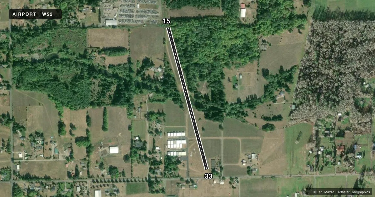
Runways & pattern
Full pagePattern entry · RWY 33
LEFT TRAFFICRunway end performance
| End | TORA | TODA | ASDA | LDA | VGSI | Approach lights | Obstruction |
|---|---|---|---|---|---|---|---|
| 15 | — | — | — | — | NSTD | — | 128', trees, 770' from thr, 0' R of cntrln, slope 6 |
| 33 | — | — | — | — | — | — | 35', pline, 157' from thr, 46' R of cntrln, slope 4 |
Declared distances in feet. TORA = takeoff run available, TODA = takeoff distance, ASDA = accelerate-stop, LDA = landing distance.
Airport sketch
Runways drawn to scale from FAA survey coordinates, rendered over satellite imagery. Not for navigation.
Approaches & charts
Services on the field
Fuel grades, oxygen, maintenance, ramp storage and lighting — as declared to the FAA by the airport operator.
Fuel & services
- Fuel
- Not available
- Oxygen (bulk)
- Not available
- Airframe repair
- Major
- Power plant repair
- Major
Ramp & ground
- Transient storage
- Tie-down
- Landing fee
- No fee published
- Customs
- Not available
- Lighting schedule
- SEE RMK
- Wind indicator
- Yes
- Segmented circle
- No
Fuel & FBOs
Cheapest 100LL and Jet A on the field and nearby. Always confirm with the FBO before taxi.
Airport notes
Surface conditions, obstructions, local procedures, lighting outages and other notes published with each FAA cycle.
General notes
- RY 07/25 FOR EMERGENCY USE ONLY.
- HNGRS 61 FT AND 67 FT FM EDGE OF RWY 07.
- RWY 25 6 FT FENCE, 16 FT FROM RWY END.
- FOR CD CTC PORTLAND APCH AT 503-493-7545.
- ROAD INTERSECTS RWY 07/25 AT MID-POINT.
- RWY 07 END, BERM, 17 FT RIGHT.
Lighting notes
- ACTVT LIRL RY 15/33 - CTAF.
Runway surface & condition
- 15/33WIDTH OF 43' OVER CULVERT IN CENTER OF FIELD.
Approach & departure obstructions
- 15HAS NSTD SINGLE LIGHT VASI BOTH SIDES OF RY.
- 073 MKR BALLS ON 45 FT PWR LINE 250 FT FM RWY END.
Other notes
- E111 PRVDD 500' DSPLCD THR RWY 33.
- 1OWNER LIVES ON ARPT.
- MANAGERALTN FONE NR 360-600-7949.
- 15/33SFC UNEVEN WITH AN INCLINE.
VFR map & nearby airports
VFR sectional. Tap any ICAO chip to open that airport.
Key facts · W52
Answer card- ICAO
- W52
- Name
- GOHEEN
- Location
- BATTLE GROUND, WASHINGTON
- Elevation
- 292 ft MSL
- Traffic pattern altitude
- 1,292 ft MSL (1,000 AGL)
- Control tower
- Non-towered (use CTAF)
- Total runways
- 1
- Longest runway
- 15/33 · 2,565 ft
- Published ILS approaches
- 0
- Published frequencies
- 1
- Magnetic variation
- 20°
- Current flight rules
- VFR
- Current wind
- 350° at 4 kt
- Favored runway now
- RWY 33
Goheen Airport (W52) sits near Battle Ground, Washington. Field elevation is 292 ft MSL. It has one runway. The longest is 15/33 at 2,565 ft on turf. There is no control tower. CTAF is 122.9. No ILS approaches are published.
Pattern altitude is not published. Use the standard 1,000 ft AGL for light piston operations unless the current FAA Chart Supplement says otherwise. The field is close enough to Portland airspace that you should pay attention to your clearance and arrival planning. For clearance delivery, the published remark says to contact Portland Approach at 503-493-7545.
Several runway notes matter here. Runway 07/25 is for emergency use only. Runway 33 has a 500-foot displaced threshold. Runway 15 has a nonstandard single-light visual approach slope indicator on both sides. The runway 15/33 surface is uneven and has an incline. There is also a road crossing runway 07/25 at the midpoint. A berm sits just right of the 07 end. A fence is near the 25 end. There are marker balls on a power line near the 07 end. No on-field FBOs are listed, so verify fuel and services with the airport operator or the FBO directly by phone before you go.