METAR & TAF 1W1
1W1 does not publish a METAR.
Showing the nearest reporting station: KTTD (PORTLAND-TROUTDALE) · 4.7 NM away. Conditions at 1W1 may differ.
METAR · KTTD
Observed 04:53Z
KTTD 270453Z VRB03KT 10SM CLR 19/13 A3004 RMK AO2 SLP172 T01940133
- Wind
- VAR @ 3 kt
- Visibility
- 10 SM
- Temp / Dew
- 19°C / 13°C
- Altimeter
- 30.04 inHg
- Clouds
- CLR
- Density alt
- 863 ft
- Ceiling
- Unlimited
- Rules
- VFR
Airport info & contacts
Manager on record, flight service, ARTCC, attendance schedule and pattern altitude — published by the FAA and refreshed every 28 days.
Location
- From city
- 3 NM N
- VFR sectional
- SEATTLE
- Pattern altitude
- 800 ft AGL · 1,229 ft MSL
- ARTCC
- ZSE · SEATTLE
- NOTAM facility
- SEA (NOTAM-D)
Airport manager
- Name
- DAVID RIPP
- Phone
- 360-835-2196
- Address
- 24 SOUTH A STREET, WASHOUGAL WA 98671
Flight service · Hours
- FSS SEA
- SEATTLE1-800-WX-BRIEF
- Attendance
- Unattended
Frequencies
Tap any row to copy the frequency to your clipboard.
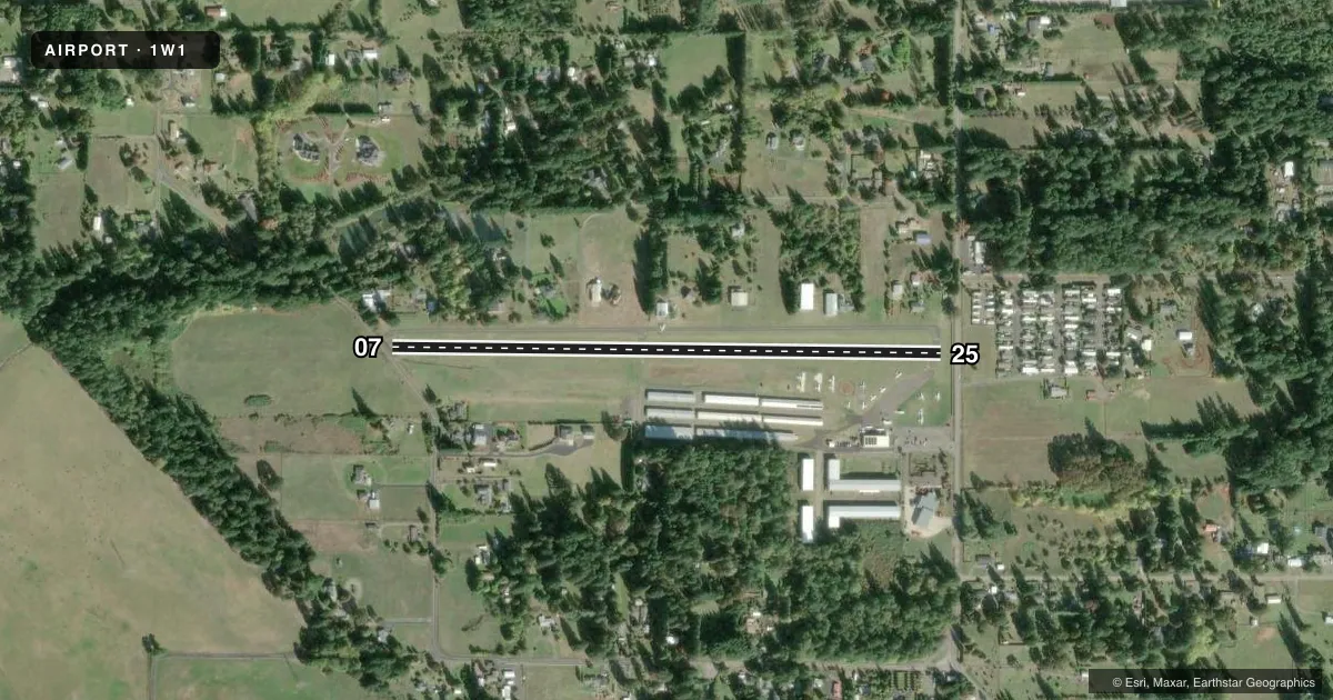
Runways & pattern
Full pagePattern entry · RWY 07
LEFT TRAFFICRunway end performance
| End | TORA | TODA | ASDA | LDA | VGSI | Approach lights | Obstruction |
|---|---|---|---|---|---|---|---|
| 07 | — | — | — | — | — | — | 100', trees, 1141' from thr, 0' R of cntrln, slope 9 |
| 25 | — | — | — | — | — | — | 32', trees, 280' from thr, 0' R of cntrln, slope 2 |
Declared distances in feet. TORA = takeoff run available, TODA = takeoff distance, ASDA = accelerate-stop, LDA = landing distance.
Airport sketch
Runways drawn to scale from FAA survey coordinates, rendered over satellite imagery. Not for navigation.
Approaches & charts
Services on the field
Fuel grades, oxygen, maintenance, ramp storage and lighting — as declared to the FAA by the airport operator.
Fuel & services
- Fuel
- 100MOGAS
- Oxygen (bottled)
- Not available
- Oxygen (bulk)
- Not available
- Airframe repair
- Not available
- Power plant repair
- Not available
- Other services
- INSTR,RNTL
Ramp & ground
- Transient storage
- Tie-down
- Landing fee
- No fee published
- Customs
- Not available
- Lighting schedule
- SEE RMK
- Beacon schedule
- SEE RMK
- Beacon
- White / Green (civil land)(WG)
- Wind indicator
- Lighted
- Segmented circle
- Yes
Fuel & FBOs
Cheapest 100LL and Jet A on the field and nearby. Always confirm with the FBO before taxi.
Airport notes
Surface conditions, obstructions, local procedures, lighting outages and other notes published with each FAA cycle.
General notes
- NOISE ABATEMENT PROCEDURES IN EFFECT, CTC PORT OF CAMAS-WASHOUGAL AT 360-835-2196.
- FOR CD CTC PORTLAND APCH AT 503-493-7545.
Lighting notes
- ACTVT ROTG BCN - CTAF.
- ACTVT MIRL RY 07/25 - CTAF.
Fuel notes
- 100FOR FUEL AFT HRS CREDIT CARD LOCK.
Runway surface & condition
- 07/25HAS BLDGS; TELEPHONE POLES; TREES ENCROACHING IN SAFETY AREAS.
- 07/25NSTD MIRL RYS 07 & 25 DSPLCD THLDS UNLGTD.
Approach & departure obstructions
- 07RWY 07 +15 FT ROAD 20 FT FM RWY END; 4 FT FENCE AND BRUSH 12 FT FM THR; 80 FT TREE, 12 FT FM THR, 99 FT LEFT; 7 FT SIGN, 88 FT LEFT.
- 25RWY 25 4 FT FENCE AND BRUSH 65 FT FM THR AND 15 FT ROAD 85 FT FM THR; 116 FT FM THR, 15 FT TREES; 10 FT SIGN 28 FT LEFT, 110 FT FM THR; 11 FT BLDG 180 FT FM THR, 53 FT LEFT; 10 FT SIGN, 108 FT FM THR, 32 FT RIGHT.
- 07RWY 07 APCH SLOPE 0:1 TO +95' TREE 33' FT FM THLD, 114' LEFT OF DSPLCD THR.
- 25RWY 25 APCH SLP 20:1 TO DSPLCD THR.
Other notes
- ESTABD PRIOR TO 15 MAY 1959.
VFR map & nearby airports
VFR sectional. Tap any ICAO chip to open that airport.
Key facts · 1W1
Answer card- ICAO
- 1W1
- Name
- GROVE FLD
- Location
- CAMAS, WASHINGTON
- Elevation
- 429 ft MSL
- Traffic pattern altitude
- 1,229 ft MSL (800 AGL)
- Control tower
- Non-towered (use CTAF)
- Total runways
- 1
- Longest runway
- 07/25 · 2,710 ft
- Published ILS approaches
- 0
- Published frequencies
- 2
- Magnetic variation
- 19°
- Current flight rules
- VFR
- Current wind
- 000° at 3 kt
- Favored runway now
- RWY 07
Grove Field sits in Camas, Washington. Field elevation is 429 ft MSL. The airport has one runway, 07/25, which is 2,710 ft long. There is no control tower. Pattern altitude is 800 ft AGL, which is 1,229 ft MSL.
No ILS approaches are published here. The field uses CTAF 122.7 and CD/P 121.65. Medium intensity runway lights on 07/25 are keyed on the CTAF. The rotating beacon is also activated by the CTAF. Published remarks say noise abatement procedures are in effect. Check the current FAA Chart Supplement before you go.
On the field, FlyIt Academy carries 100LL and MOGAS. Grove Field carries 100LL. For fuel after hours, the remarks say to use the credit card lock. The airport also has several published obstructions near both runway ends. Runway 07 has a road, fence, brush, an 80 ft tree and a sign close in. Runway 25 has a fence, brush, road, trees, signs and an 11 ft building near the approach. That makes a careful look at the current runway and threshold setup a smart move before arrival.
For a first-time pilot, the main things are the short runway, the displaced thresholds and the obstacle environment. Review the current Chart Supplement and coordinate with the airport operator if you need local guidance.