METAR & TAF KSPB
Current METAR
Observed 04:53Z
KSPB 270453Z AUTO 36004KT 10SM CLR 18/12 A3005 RMK AO2 SLP174 T01780117
- Wind
- 360° @ 4 kt
- Visibility
- 10 SM
- Temp / Dew
- 18°C / 12°C
- Altimeter
- 30.05 inHg
- Clouds
- CLR
- Density alt
- 271 ft
- Ceiling
- Unlimited
- Rules
- VFR
Airport info & contacts
Manager on record, flight service, ARTCC, attendance schedule and pattern altitude — published by the FAA and refreshed every 28 days.
Location
- From city
- 1 NM NE
- VFR sectional
- SEATTLE
- ARTCC
- ZSE · SEATTLE
- NOTAM facility
- SPB (NOTAM-D)
Airport manager
- Name
- CRAIG ALLISON
- Phone
- 503-397-2888
- Address
- PO BOX 190, COLUMBIA CITY OR 97018
Flight service · Hours
- FSS MMV
- MC MINNVILLE1-800-WX-BRIEF
- Attendance
- 0800-DUSK
Frequencies
Tap any row to copy the frequency to your clipboard.
Runways & pattern
Full pagePattern entry · RWY 33
RIGHT TRAFFICRunway end performance
| End | TORA | TODA | ASDA | LDA | VGSI | Approach lights | Obstruction |
|---|---|---|---|---|---|---|---|
| 15 | — | — | — | — | PAPI 4-box left(3.73°) | — | 58', tree, 475' from thr, 262' R of cntrln, slope 4 |
| 33 | — | — | — | — | PAPI 4-box left(3°) | — | — |
Declared distances in feet. TORA = takeoff run available, TODA = takeoff distance, ASDA = accelerate-stop, LDA = landing distance.
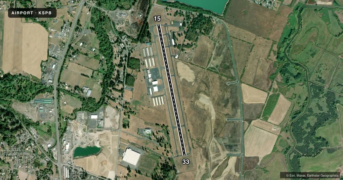
Airport sketch
Runways drawn to scale from FAA survey coordinates, rendered over satellite imagery. Not for navigation.
Approaches & charts
ILS · 1
Services on the field
Fuel grades, oxygen, maintenance, ramp storage and lighting — as declared to the FAA by the airport operator.
Fuel & services
- Fuel
- 100LLA
- Airframe repair
- Major
- Power plant repair
- Major
- Other services
- AGRI,INSTR,RNTL
Ramp & ground
- Transient storage
- Tie-down
- Landing fee
- No fee published
- Customs
- Not available
- Lighting schedule
- SEE RMK
- Beacon schedule
- SS-SR
- Beacon
- White / Green (civil land)(WG)
- Wind indicator
- Lighted
- Segmented circle
- Yes
Fuel & FBOs
Cheapest 100LL and Jet A on the field and nearby. Always confirm with the FBO before taxi.
Airport notes
Surface conditions, obstructions, local procedures, lighting outages and other notes published with each FAA cycle.
General notes
- BLUE LGTS & CNTRLN REFLECTORS E SIDE TWY EXITS.
- ULTRALIGHT ACT W SIDE PARL TWY.
- TWY B MED INTST TWY LGTS.
- FOR CD CTC PORTLAND APPROACH AT 503-493-7545.
Lighting notes
- ACTVT REIL RWY 15; PAPI RWY 15 & 33; MIRL RWY 15/33; - CTAF. ACTVT REIL 7 CLICKS.
Runway surface & condition
- 15/33RWY 15 CALM WIND RWY.
Other notes
- THIS AIRPORT HAS BEEN SURVEYED BY THE NATIONAL GEODETIC SURVEY.
VFR map & nearby airports
VFR sectional. Tap any ICAO chip to open that airport.
Key facts · KSPB
Answer card- ICAO
- KSPB
- Name
- SCAPPOOSE
- Location
- SCAPPOOSE, OREGON
- Elevation
- 58.1 ft MSL
- Traffic pattern altitude
- 1,058.1 ft MSL (1,000 AGL)
- Control tower
- Non-towered (use CTAF)
- Total runways
- 1
- Longest runway
- 15/33 · 5,100 ft
- Published ILS approaches
- 1
- Published frequencies
- 6
- Magnetic variation
- 17°
- Current flight rules
- VFR
- Current wind
- 360° at 4 kt
- Favored runway now
- RWY 33
Scappoose Airport sits in Scappoose, Oregon at 58.1 ft MSL. It has one runway. Runway 15/33 is 5,100 ft long, which is the longest runway on the field. There is no control tower. Clearance delivery goes through Portland Approach. Towered traffic is not part of the picture here, so watch the CTAF closely and make your calls early.
The field has one ILS approach. It serves Runway 15. Runway 15 is also the calm wind runway. Pattern altitude is not published, so use the standard 1,000 ft AGL for light piston operations unless the current FAA Chart Supplement says otherwise. Transwestern Aviation is on the field. It carries 100LL and Jet A. For a first visit, pay attention to the west side parallel taxiway. Ultralight activity is published there. Taxiway B has medium intensity taxiway lights. Runway 15 and Runway 33 have medium intensity runway lights. Runway 15 also has REILs and both runway ends have PAPI. On CTAF, the REILs activate with seven clicks.