METAR & TAF W27
W27 does not publish a METAR.
Showing the nearest reporting station: KSPB (SCAPPOOSE) · 9.3 NM away. Conditions at W27 may differ.
METAR · KSPB
Observed 03:53Z
KSPB 270353Z AUTO 32007KT 10SM CLR 19/12 A3003 RMK AO2 SLP170 T01890122
- Wind
- 320° @ 7 kt
- Visibility
- 10 SM
- Temp / Dew
- 19°C / 12°C
- Altimeter
- 30.03 inHg
- Clouds
- CLR
- Density alt
- 380 ft
- Ceiling
- Unlimited
- Rules
- VFR
Airport info & contacts
Manager on record, flight service, ARTCC, attendance schedule and pattern altitude — published by the FAA and refreshed every 28 days.
Location
- From city
- 1 NM SE
- VFR sectional
- SEATTLE
- ARTCC
- ZSE · SEATTLE
- NOTAM facility
- SEA (NOTAM-D)
Airport manager
- Name
- JOHN WILSON
- Phone
- 360-618-2477
- Address
- PO BOX 47312, OLYMPIA WA 98504-7264
Flight service · Hours
- FSS SEA
- SEATTLE1-800-WX-BRIEF
- Attendance
- Unattended
Frequencies
Tap any row to copy the frequency to your clipboard.
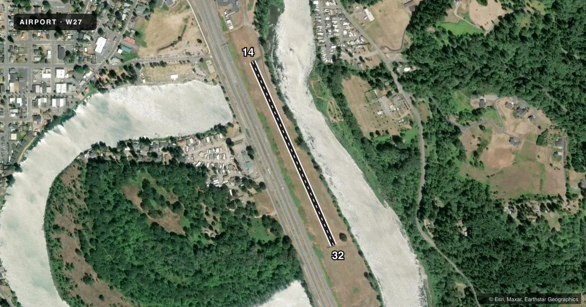
Runways & pattern
Full pagePattern entry · RWY 32
LEFT TRAFFICRunway end performance
| End | TORA | TODA | ASDA | LDA | VGSI | Approach lights | Obstruction |
|---|---|---|---|---|---|---|---|
| 14 | — | — | — | — | — | — | 40', pole, 245' from thr, 114' R of cntrln, slope 1 |
| 32 | — | — | — | — | — | — | 30', trees, 800' from thr, 0' R of cntrln, slope 20 |
Declared distances in feet. TORA = takeoff run available, TODA = takeoff distance, ASDA = accelerate-stop, LDA = landing distance.
Airport sketch
Runways drawn to scale from FAA survey coordinates, rendered over satellite imagery. Not for navigation.
Approaches & charts
Services on the field
Fuel grades, oxygen, maintenance, ramp storage and lighting — as declared to the FAA by the airport operator.
Fuel & services
- Fuel
- Not available
- Oxygen (bottled)
- Not available
- Oxygen (bulk)
- Not available
- Airframe repair
- Not available
- Power plant repair
- Not available
Ramp & ground
- Transient storage
- Tie-down
- Landing fee
- No fee published
- Customs
- Not available
- Lighting schedule
- SS-SR
- Wind indicator
- Yes
- Segmented circle
- No
Fuel & FBOs
Cheapest 100LL and Jet A on the field and nearby. Always confirm with the FBO before taxi.
Airport notes
Surface conditions, obstructions, local procedures, lighting outages and other notes published with each FAA cycle.
General notes
- PLINE IN APCH TO RY 14.
- 12 FT DIKE NW END.
- VEHICLES, PEDESTRIANS, AND ANIMALS ON AND INVOF ARPT.
- 6 FT FENCE IN PRIMARY SFC, 105 FT FROM CNTRLN, WEST OF RWY AND RUNS ENTIRE LENGTH.
- NAV BUOYS MRKG SOUTH SIDE OF COML WATERLINE LGTD WITH FLG DIM RED LGTS; BLINK AT APRXLY 2-SEC INTVLS & EXTREMELY DFCLT TO SEE.
Runway surface & condition
- 14/32ACTVT LIRL RWY 14/32 5 MIC CLICKS - CTAF.
Approach & departure obstructions
- 14RY 14 MRKGS FADED.
- 32RY 32 MRKG FADED.
- 1420:1 SLOPE TO DSPLCD THR.
VFR map & nearby airports
VFR sectional. Tap any ICAO chip to open that airport.
Key facts · W27
Answer card- ICAO
- W27
- Name
- WOODLAND STATE
- Location
- WOODLAND, WASHINGTON
- Elevation
- 29 ft MSL
- Traffic pattern altitude
- 1,029 ft MSL (1,000 AGL)
- Control tower
- Non-towered (use CTAF)
- Total runways
- 1
- Longest runway
- 14/32 · 2,245 ft
- Published ILS approaches
- 0
- Published frequencies
- 1
- Magnetic variation
- 20°
- Current flight rules
- VFR
- Current wind
- 320° at 7 kt
- Favored runway now
- RWY 32
Woodland State Airport is in Woodland, Washington. The field elevation is 29 ft MSL. It has one runway, 14/32, which is 2,245 ft long and paved. There is no control tower. CTAF is 122.9. No ILS approaches are published here.
Pattern altitude is not published. Use 1,000 ft AGL for light piston planning unless the current Chart Supplement says otherwise. Runway headings are magnetic. The published runway headings are 156° and 336°.
This is a small field with several things to watch on arrival. Vehicles, pedestrians and animals may be on or near the airport. Runway 14 has a power line in the approach. Runway 14 and runway 32 both have faded markings. Runway 14 uses a displaced threshold with a 20 to 1 slope to it. A 6-foot fence sits in the primary surface west of the runway. There is also a 12-foot dike at the northwest end. The south side commercial waterline has lighted buoys that are hard to see at night.
No on-field FBOs are listed. Check the current FAA Chart Supplement or call the airport operator before you go. For a first-time pilot, the main points are the short runway, the approach obstruction on 14 and the mixed airport environment near the field.