METAR & TAF 05S
05S does not publish a METAR.
Showing the nearest reporting station: KSPB (SCAPPOOSE) · 16.7 NM away. Conditions at 05S may differ.
METAR · KSPB
Observed 16:53Z
KSPB 261653Z AUTO 14007KT 10SM SCT035 OVC047 21/13 A3006 RMK AO2 SLP178 T02060128
- Wind
- 140° @ 7 kt
- Visibility
- 10 SM
- Temp / Dew
- 21°C / 13°C
- Altimeter
- 30.06 inHg
- Clouds
- OVC
- Density alt
- 1,352 ft
- Ceiling
- 4,700 ft AGL
- Rules
- VFR
Airport info & contacts
Manager on record, flight service, ARTCC, attendance schedule and pattern altitude — published by the FAA and refreshed every 28 days.
Location
- From city
- 2 NM W
- VFR sectional
- SEATTLE
- ARTCC
- ZSE · SEATTLE
- NOTAM facility
- MMV (NOTAM-D)
Airport manager
- Name
- MICHAEL SEAGER
- Phone
- 503-709-4075
- Address
- 536 1ST AVE., VERNONIA OR 97064
Flight service · Hours
- FSS MMV
- MC MINNVILLE1-800-WX-BRIEF
- Attendance
- Unattended
Frequencies
Tap any row to copy the frequency to your clipboard.
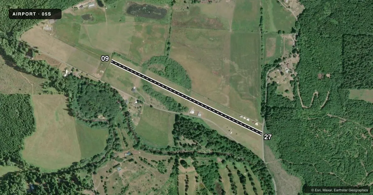
Runways & pattern
Full pagePattern entry · RWY 09
RIGHT TRAFFICRunway end performance
| End | TORA | TODA | ASDA | LDA | VGSI | Approach lights | Obstruction |
|---|---|---|---|---|---|---|---|
| 09 | — | — | — | — | — | — | 4', fence, 0' from thr, 0' R of cntrln, slope 0 |
| 27 | — | — | — | — | — | — | 15', road, 3' from thr, 0' R of cntrln, slope 1 |
Declared distances in feet. TORA = takeoff run available, TODA = takeoff distance, ASDA = accelerate-stop, LDA = landing distance.
Airport sketch
Runways drawn to scale from FAA survey coordinates, rendered over satellite imagery. Not for navigation.
Approaches & charts
Services on the field
Fuel grades, oxygen, maintenance, ramp storage and lighting — as declared to the FAA by the airport operator.
Fuel & services
- Fuel
- Not available
- Oxygen (bottled)
- Not available
- Oxygen (bulk)
- Not available
- Airframe repair
- Not available
- Power plant repair
- Not available
Ramp & ground
- Transient storage
- Tie-down
- Landing fee
- No fee published
- Customs
- Not available
- Wind indicator
- No
- Segmented circle
- No
Fuel & FBOs
Cheapest 100LL and Jet A on the field and nearby. Always confirm with the FBO before taxi.
Airport notes
Surface conditions, obstructions, local procedures, lighting outages and other notes published with each FAA cycle.
General notes
- HANGARS 100 FT RIGHT OF CNTRLN ON AER 27.
- RY 27 HAS MULTIPLE OBSTRUCTIONS WITHIN 1000 FT E. CURVED APCH FM THE SOUTHEAST RECOMMENDED.
- RY 09 4FT FENCE AT RY END MARKED BY ORANGE PYLONS.
- RY 27 10 FT ROAD 10 FT FROM RY END.
- DEER AND ELK ON AND IN VICINITY OF AIRPORT
- FOR CD CTC PORTLAND APCH AT 503-493-7545.
Approach & departure obstructions
- 09BEYOND FENCE, OBSTRUCTION CLEARANCE SLOPE IS 9:1.
- 09RWY EDGE MKD WITH W MATS.
- 27RWY EDGE MKD WITH W MATS.
Other notes
- EXISTED PRIOR TO 1959.
VFR map & nearby airports
VFR sectional. Tap any ICAO chip to open that airport.
Key facts · 05S
Answer card- ICAO
- 05S
- Name
- VERNONIA MUNI
- Location
- VERNONIA, OREGON
- Elevation
- 650 ft MSL
- Traffic pattern altitude
- 1,650 ft MSL (1,000 AGL)
- Control tower
- Non-towered (use CTAF)
- Total runways
- 1
- Longest runway
- 09/27 · 2,940 ft
- Published ILS approaches
- 0
- Published frequencies
- 1
- Magnetic variation
- 20°
- Current flight rules
- VFR
- Current wind
- 140° at 7 kt
- Favored runway now
- RWY 09
Vernonia Muni sits in Vernonia, Oregon at 650 ft MSL. It has one runway. Runway 09/27 is 2,940 ft of turf, so plan for short-field performance and soft-field technique. There is no control tower. CTAF is 122.9. No ILS approaches are published for the field.
The pattern altitude is not published. Use the standard 1,000 ft AGL pattern unless the current FAA Chart Supplement says otherwise. That puts the light aircraft pattern at 1,650 ft MSL based on the listed field elevation. The airport is a small public-use strip with no on-field FBOs listed. Verify fuel and services with the airport operator or the FBO directly by phone before you go.
The published remarks matter here. Runway 27 has multiple obstructions within 1,000 ft. A curved approach from the southeast is recommended. There is also a 10-foot road close to the runway 27 end. The runway 09 end has a 4-foot fence marked by orange pylons. Deer and elk are reported on and near the airport. If you are planning a first visit, brief the turf surface, the obstruction picture and the wildlife risk before arrival. For clearance delivery, Portland Approach is listed in the remarks. Check the current FAA Chart Supplement for any updated procedures before flying in.