METAR & TAF KKLS
Current METAR
Observed 20:56Z
KKLS 262056Z AUTO 16007KT 10SM OVC049 24/12 A3006 RMK AO2 SLP184 6//// T02390117 55001 PNO $
- Wind
- 160° @ 7 kt
- Visibility
- 10 SM
- Temp / Dew
- 24°C / 12°C
- Altimeter
- 30.06 inHg
- Clouds
- OVC
- Density alt
- 931 ft
- Ceiling
- 4,900 ft AGL
- Rules
- VFR
Airport info & contacts
Manager on record, flight service, ARTCC, attendance schedule and pattern altitude — published by the FAA and refreshed every 28 days.
Location
- From city
- 2 NM SE
- VFR sectional
- SEATTLE
- ARTCC
- ZSE · SEATTLE
- NOTAM facility
- KLS (NOTAM-D)
Airport manager
- Name
- CRAIG STOMMEL
- Phone
- 360-261-8268
- Address
- PO BOX 818, KELSO WA 98626
Flight service · Hours
- FSS SEA
- SEATTLE1-800-WX-BRIEF
- Attendance
- 0800-1700
Frequencies
Tap any row to copy the frequency to your clipboard.
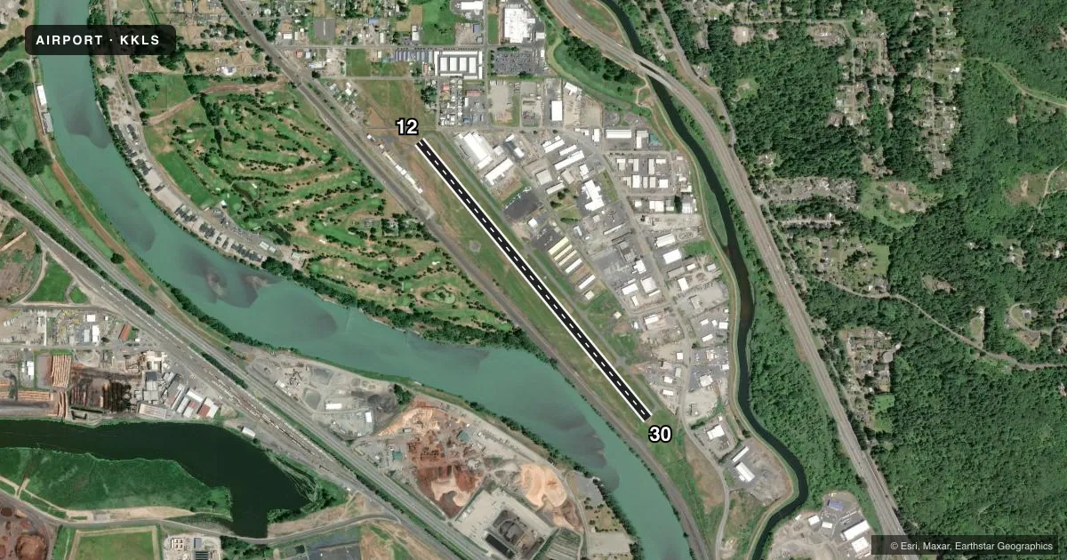
Runways & pattern
Full pagePattern entry · RWY 12
RIGHT TRAFFICRunway end performance
| End | TORA | TODA | ASDA | LDA | VGSI | Approach lights | Obstruction |
|---|---|---|---|---|---|---|---|
| 12 | — | — | — | — | PAPI 4-box right(4°) | — | 45', trees, 1300' from thr, 110' R of cntrln, slope 24 |
| 30 | — | — | — | — | PAPI 4-box left(4°) | — | — |
Declared distances in feet. TORA = takeoff run available, TODA = takeoff distance, ASDA = accelerate-stop, LDA = landing distance.
Airport sketch
Runways drawn to scale from FAA survey coordinates, rendered over satellite imagery. Not for navigation.
Approaches & charts
Services on the field
Fuel grades, oxygen, maintenance, ramp storage and lighting — as declared to the FAA by the airport operator.
Fuel & services
- Fuel
- 100LLA
- Oxygen (bottled)
- Not available
- Oxygen (bulk)
- Not available
- Airframe repair
- Major
- Power plant repair
- Major
- Other services
- AVNCS,INSTR,RNTL
Ramp & ground
- Transient storage
- Tie-down
- Landing fee
- No fee published
- Customs
- Not available
- Lighting schedule
- SEE RMK
- Beacon schedule
- SS-SR
- Beacon
- White / Green (civil land)(WG)
- Wind indicator
- Lighted
- Segmented circle
- Yes
Fuel & FBOs
Cheapest 100LL and Jet A on the field and nearby. Always confirm with the FBO before taxi.
Airport notes
Surface conditions, obstructions, local procedures, lighting outages and other notes published with each FAA cycle.
General notes
- NMRS FLOCKS OF BIRDS ON & INVOF ARPT.
- NO FLD COND NOTAMS AVBL M-F 1700-0800.
- FOR CD IF UNA TO CTC ON FSS FREQ, CTC SEATTLE ARTCC AT 253-351-3694.
Lighting notes
- ACTVT REIL RWY 12 & 30; PAPI RWY 12 & 30; MIRL RWY 12/30 - CTAF.
Fuel notes
- 100LL24 HR SELF SVC CREDIT CARD FUEL FAC 100LL. AFT HRS JET-A SVC CALL-OUT AVBL.
Runway surface & condition
- 12/30RY 12/30 MIRL NSTD SPACING.
Approach & departure obstructions
- 30+3' HILL FROM 40' TO 200'; 105L.
Other notes
- ESTABD PRIOR TO 15 MAY 1959.
- FLIGHT NOTIFICATION SERVICE (ADCUS) AVBL.
- PILOTS BRING OWN TIEDOWNS.
- MIDFIELD, OTS INDEFLY.
- MANAGERARPT OFC ADS (NOT FOR MAILING): 2215 B PARROTT WAY, KELSO, WA 98626
VFR map & nearby airports
VFR sectional. Tap any ICAO chip to open that airport.
Key facts · KKLS
Answer card- ICAO
- KKLS
- Name
- SOUTHWEST WASHINGTON RGNL
- Location
- KELSO, WASHINGTON
- Elevation
- 20.1 ft MSL
- Traffic pattern altitude
- 1,020.1 ft MSL (1,000 AGL)
- Control tower
- Non-towered (use CTAF)
- Total runways
- 1
- Longest runway
- 12/30 · 4,391 ft
- Published ILS approaches
- 0
- Published frequencies
- 2
- Magnetic variation
- 17°
- Current flight rules
- VFR
- Current wind
- 160° at 7 kt
- Favored runway now
- RWY 12
Southwest Washington Rgnl is in Kelso, Washington. Field elevation is 20.1 ft MSL. The airport has one runway, 12/30, which is 4,391 ft long. There is no control tower. CTAF and UNICOM are both 122.725. No ILS approaches are published here.
Pattern altitude is not published in the facts. Use the standard 1,000 ft AGL for light piston traffic unless the current Chart Supplement says otherwise. Cascade Air is the on-field FBO. It carries 100LL, Jet-A and Jet-A Prist. It also has 24-hour self-serve credit card fuel for 100LL. After-hours Jet-A service is available by call-out. Runway 12/30 has medium intensity lights with nonstandard spacing. REILs and PAPI are installed on both ends. The published remarks also note a +3 ft hill near the departure end of runway 30. The obstruction area extends from about 40 ft to 200 ft and is offset 105 degrees left. Expect bird activity in and around the airport. Pilots should also bring their own tiedowns. For clearance delivery issues, the Chart Supplement says Seattle ARTCC can be contacted if flight service cannot be reached.