METAR & TAF KTDO
KTDO does not publish a METAR.
Showing the nearest reporting station: KCLS (CHEHALIS-CENTRALIA) · 14.0 NM away. Conditions at KTDO may differ.
METAR · KCLS
Observed 10:55Z
KCLS 271055Z AUTO 21004KT 10SM FEW033 OVC120 14/14 A3008 RMK AO2
- Wind
- 210° @ 4 kt
- Visibility
- 10 SM
- Temp / Dew
- 14°C / 14°C
- Altimeter
- 30.08 inHg
- Clouds
- OVC
- Density alt
- 145 ft
- Ceiling
- 12,000 ft AGL
- Rules
- VFR
Airport info & contacts
Manager on record, flight service, ARTCC, attendance schedule and pattern altitude — published by the FAA and refreshed every 28 days.
Location
- From city
- 3 NM N
- VFR sectional
- SEATTLE
- Pattern altitude
- 800 ft AGL · 1,174 ft MSL
- ARTCC
- ZSE · SEATTLE
- NOTAM facility
- TDO (NOTAM-D)
Airport manager
- Name
- RUSS MORTON
- Phone
- 360-864 4966
- Address
- 5239 JACKSON HWY, TOLEDO WA 98591-9732
Flight service · Hours
- FSS SEA
- SEATTLE1-800-WX-BRIEF
- Attendance
- MON-FRI · 1000-1700
Frequencies
Tap any row to copy the frequency to your clipboard.
Runways & pattern
Full pagePattern entry · RWY 24
LEFT TRAFFICRunway end performance
| End | TORA | TODA | ASDA | LDA | VGSI | Approach lights | Obstruction |
|---|---|---|---|---|---|---|---|
| 06 | — | — | — | — | PAPI 2-box left(3°) | — | 100', trees, 2723' from thr, 0' R of cntrln, slope 25 |
| 24 | — | — | — | — | PAPI 2-box left(3°) | — | — |
Declared distances in feet. TORA = takeoff run available, TODA = takeoff distance, ASDA = accelerate-stop, LDA = landing distance.
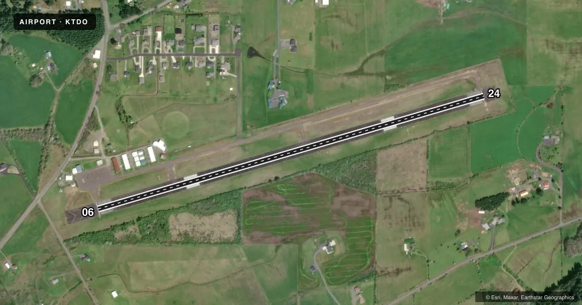
Airport sketch
Runways drawn to scale from FAA survey coordinates, rendered over satellite imagery. Not for navigation.
Approaches & charts
Services on the field
Fuel grades, oxygen, maintenance, ramp storage and lighting — as declared to the FAA by the airport operator.
Fuel & services
- Fuel
- 100LL
- Oxygen (bottled)
- Not available
- Oxygen (bulk)
- Not available
- Airframe repair
- Minor
- Power plant repair
- Minor
- Other services
- GLD,INSTR,PAJA
Ramp & ground
- Transient storage
- Tie-down
- Landing fee
- No fee published
- Customs
- Not available
- Lighting schedule
- SEE RMK
- Beacon schedule
- SS-SR
- Beacon
- White / Green (civil land)(WG)
- Wind indicator
- Lighted
- Segmented circle
- No
Fuel & FBOs
Cheapest 100LL and Jet A on the field and nearby. Always confirm with the FBO before taxi.
Airport notes
Surface conditions, obstructions, local procedures, lighting outages and other notes published with each FAA cycle.
General notes
- RDO CTL ACFT ADJ RWY 06/24 400 FT S & BLW.
- DISTANCE TO GO MARKERS SOUTHSIDE OF RY.
- GLDR ACT JUL-NOV.
- LNAV GPS APPROACHES CURRENTLY PUBLISHED TO BOTH RUNWAY ENDS, MINIMA AS LOW AS 1 MILE.
- FOR CD CTC SEATTLE ARTCC AT 253-351-3694.
- DEER INVOF RWY.
Lighting notes
- ACTVT REIL RWY 06 & 24; MIRL RWY 06/24 - CTAF. PAPI RWY 06 & 24 OPR CONSLY.
Fuel notes
- 100LL24 HR CREDIT CARD FUEL FAC.
Approach & departure obstructions
- 244 FT FENCE 300 FT FROM END BOTH SIDES OF CL.
Other notes
- ARPT ESTABD PRIOR TO 1959.
- PILOTS BRING OWN TIEDOWNS.
VFR map & nearby airports
VFR sectional. Tap any ICAO chip to open that airport.
Key facts · KTDO
Answer card- ICAO
- KTDO
- Name
- ED CARLSON MEML FLD/SOUTH LEWIS COUNTY
- Location
- TOLEDO, WASHINGTON
- Elevation
- 373.9 ft MSL
- Traffic pattern altitude
- 1,173.9 ft MSL (800 AGL)
- Control tower
- Non-towered (use CTAF)
- Total runways
- 1
- Longest runway
- 06/24 · 4,479 ft
- Published ILS approaches
- 0
- Published frequencies
- 1
- Magnetic variation
- 17°
- Current flight rules
- VFR
- Current wind
- 210° at 4 kt
- Favored runway now
- RWY 24
Ed Carlson Meml Fld/South Lewis County sits in Toledo, Washington. Field elevation is 373.9 ft MSL. The airport has one runway, 06/24, which is 4,479 ft long and paved. There is no control tower. CTAF is 122.9. Pattern altitude is 800 ft AGL, which is 1,173.9 ft MSL.
No ILS approaches are published here. LPV GPS approaches are published to both runway ends with minimums as low as 1 mile. The runway lighting is pilot controlled on CTAF. Runway end identifier lights are active on both ends. PAPI is also available on both runways. The on-field FBO is Ed Carlson Memorial Field. It carries 100LL. A 24-hour credit card fuel facility is available for 100LL.
A few local items matter on first arrival. Glider activity runs from July through November. Deer are in the vicinity of the runway. There is also a 4-foot fence 300 feet from the end of runway 24 on both sides of the centerline. Pilots must bring their own tiedowns. Clearance delivery is handled through Seattle ARTCC at 253-351-3694. Check the current FAA Chart Supplement for any updated operational notes before you go.