METAR & TAF 39P
39P does not publish a METAR.
Showing the nearest reporting station: KCLS (CHEHALIS-CENTRALIA) · 30.5 NM away. Conditions at 39P may differ.
METAR · KCLS
Observed 12:35Z
KCLS 271235Z AUTO 00000KT 10SM BKN110 14/14 A3009 RMK AO2
- Wind
- 000° @ 0 kt
- Visibility
- 10 SM
- Temp / Dew
- 14°C / 14°C
- Altimeter
- 30.09 inHg
- Clouds
- BKN
- Density alt
- 836 ft
- Ceiling
- 11,000 ft AGL
- Rules
- VFR
Airport info & contacts
Manager on record, flight service, ARTCC, attendance schedule and pattern altitude — published by the FAA and refreshed every 28 days.
Location
- From city
- 0 NM SE
- VFR sectional
- SEATTLE
- ARTCC
- ZSE · SEATTLE
- NOTAM facility
- SEA (NOTAM-D)
Airport manager
- Name
- ANDERS POLLMAN
- Phone
- (360) 496-5210
- Address
- PO BOX 1089, PO BOX 1089, MORTON WA 98356
Flight service · Hours
- FSS SEA
- SEATTLE1-800-WX-BRIEF
- Attendance
- Unattended
Frequencies
Tap any row to copy the frequency to your clipboard.
Runways & pattern
Full pagePattern entry · RWY 07
LEFT TRAFFICRunway end performance
| End | TORA | TODA | ASDA | LDA | VGSI | Approach lights | Obstruction |
|---|---|---|---|---|---|---|---|
| 07 | — | — | — | — | — | — | 50', pline, 324' from thr, 0' R of cntrln, slope 2 |
Declared distances in feet. TORA = takeoff run available, TODA = takeoff distance, ASDA = accelerate-stop, LDA = landing distance.
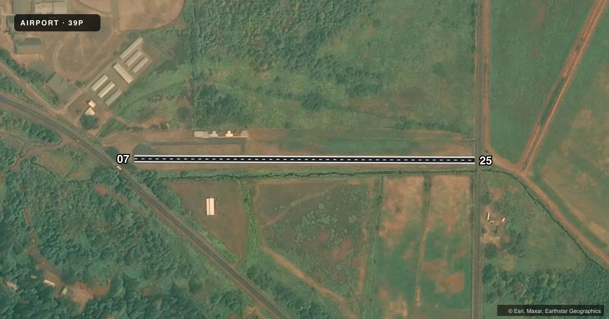
Airport sketch
Runways drawn to scale from FAA survey coordinates, rendered over satellite imagery. Not for navigation.
Approaches & charts
Services on the field
Fuel grades, oxygen, maintenance, ramp storage and lighting — as declared to the FAA by the airport operator.
Fuel & services
- Fuel
- Not available
- Airframe repair
- Not available
- Power plant repair
- Not available
Ramp & ground
- Transient storage
- Tie-down
- Landing fee
- No fee published
- Lighting schedule
- SEE RMK
- Beacon schedule
- SEE RMK
- Beacon
- White / Green (civil land)(WG)
- Wind indicator
- Lighted
- Segmented circle
- No
Fuel & FBOs
Cheapest 100LL and Jet A on the field and nearby. Always confirm with the FBO before taxi.
Airport notes
Surface conditions, obstructions, local procedures, lighting outages and other notes published with each FAA cycle.
General notes
- TREES NEAR RWY.
- TREES, STREAM, AND BRUSH IN PRIM SFC.
- DEER AND ELK ON & INVOF RWY.
- DITCH PARL RWY ON EASTSIDE.
- FOR CD CTC SEATTLE ARTCC AT 253-351-3694.
- SLP ON N SIDE ON RWY MID-FIELD BGNG AT SHOULDER.
Lighting notes
- ACTVT ROTG BCN - CTAF.
- ACTVT MIRL RY 07/25 - CTAF.
Approach & departure obstructions
- 07+3 FT FENCE AT 35 FT FM THR AND 32 FT R; GUARD RAIL AND ROAD 98 FT FM THR; 15 FT SIGN, 18 FT R, 65 FT FM THR; TREE, 51 FT HIGH, 2 FT R, 120 FT FM THR, 10 FT SIGN 84 FT L, 30 FT FM THR; FENCE 102 FT L, 15 FT FM THR; ROAD 120 FT L.
- 25RWY 25 +2 FT ROAD AND GUARD RAIL AT 15 FT FM THR; TREE, 15 FT HIGH, 49 FT R, 74 FT FM THR; POLE, 4 FT HIGH, 79 FT R, 8 FT FM THR.
- 07MARKINGS FADED.
- 25MARKINGS FADED.
- 07APCH SLOPE 8:1 TO DSPLCD THLD.
Other notes
- PRVDD PLINES REMOVED OR RELCTD.
- PILOTS BRING OWN TIEDOWNS.
- MANAGERPUB. WKS. SUP.
- 07/25WDSPR RAVELLING AND ALLIGATOR CRACKING.
VFR map & nearby airports
VFR sectional. Tap any ICAO chip to open that airport.
Key facts · 39P
Answer card- ICAO
- 39P
- Name
- STROM FLD
- Location
- MORTON, WASHINGTON
- Elevation
- 941 ft MSL
- Traffic pattern altitude
- 1,941 ft MSL (1,000 AGL)
- Control tower
- Non-towered (use CTAF)
- Total runways
- 1
- Longest runway
- 07/25 · 1,810 ft
- Published ILS approaches
- 0
- Published frequencies
- 1
- Magnetic variation
- 20°
- Current flight rules
- VFR
- Current wind
- 000° at 0 kt
- Favored runway now
- –
STROM FLD sits in Morton, Washington. Field elevation is 941 ft MSL. It has one runway, 07/25, which is 1,810 ft long and asphalt. There is no control tower. CTAF is 122.9. No ILS approaches are published here.
Pattern altitude is not published. Use the current FAA Chart Supplement before you go. The field has a number of published obstructions and surface issues that matter on a first visit. Trees, brush and a stream are in the primary surface. There is also a ditch parallel to the runway on the east side. Runway 07 has a displaced-threshold approach slope and several close-in obstacles. Runway 25 also has close-in road, guard rail, tree and pole hazards. Markings on both runway ends are faded.
There are no on-field FBOs listed. Pilots must bring their own tiedowns. The rotating beacon is activated by the CTAF. For clearance delivery, contact Seattle ARTCC at 253-351-3694. This is a small field with limited margin, so plan your takeoff and landing performance carefully. Check the current FAA Chart Supplement for any noise or operating notes before you go.